![](/images/other/stat-length.png)
![Trail Walking Bueil-en-Touraine - Bueil en Touraine-9,6 KM-Le 19 Février 2015 - Auteur tintin37 - Photo](https://media.geolcdn.com/t/1900/400/ext.pjpeg?maxdim=2&url=https%3A%2F%2Fstatic1.geolcdn.com%2Fsiteimages%2Fupload%2Ffiles%2F1553511878bg_sport_marche.png)
Bueil en Touraine-9,6 KM-Le 19 Février 2015 - Auteur tintin37
Martinjeanclaude
User
![Length](/images/other/stat-length.png)
Length
9.8 km
![Max alt](https://static1.geolcdn.com/siteimages/upload/files/1508320355ic_sort_altitude_max_24dp.png)
Max alt
119 m
![Uphill gradient](https://static1.geolcdn.com/siteimages/upload/files/1508320355ic_sort_den_pos_24dp.png)
Uphill gradient
135 m
![Km-Effort](/images/other/stat-length.png)
Km-Effort
11.6 km
![Min alt](https://static1.geolcdn.com/siteimages/upload/files/1508320355ic_sort_altitude_min_24dp.png)
Min alt
61 m
![Downhill gradient](https://static1.geolcdn.com/siteimages/upload/files/1508320355ic_sort_den_neg_24dp.png)
Downhill gradient
133 m
![Boucle](https://static1.geolcdn.com/siteimages/upload/files/16400158638029165_repeat_loop_refresh_sync_direction_icon.png)
Boucle
Yes
Creation date :
2015-02-19 00:00:00.0
Updated on :
2015-02-19 00:00:00.0
![Walking](https://static1.geolcdn.com/sitytour/trail-icons/101.png)
2h31
Difficulty : Medium
![Scan this QR Code to open this trail in the SityTrail application](https://capi.geolives.com/qq0zvz2zws4bq2lad0pu/sitytour/trails/387958/qr.png?size=200)
FREE GPS app for hiking
About
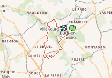
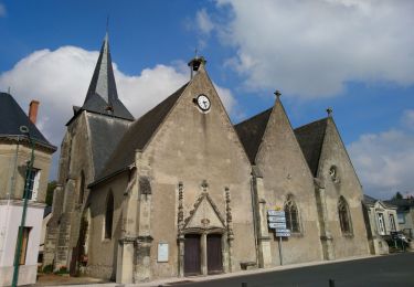
Trail Walking of 9.8 km to be discovered at Centre-Loire Valley, Indre-et-Loire, Bueil-en-Touraine. This trail is proposed by Martinjeanclaude.
Description
PARKING route de la mairie face a l'école Parcours assez plaisant dans la vallée du Long ,alternance entre bois route et plaine , en passant par Villebourg , très valloné , avec quelques gués pour prende des bains de pieds
Positioning
Country:
France
Region :
Centre-Loire Valley
Department/Province :
Indre-et-Loire
Municipality :
Bueil-en-Touraine
Location:
Unknown
Start:(Dec)
Start:(UTM)
316026 ; 5279714 (31T) N.
Comments
Trails nearby
![Trail Walking Saint-Paterne-Racan - Saint-Paterne-Racan - Circuit 2 avec variantes - 19.1km 215m 4h10 - 2020 09 19 - Photo](https://media.geolcdn.com/t/375/260/887e63cd-caa4-49a3-ac0f-9649db92646b.jpg&format=jpg&maxdim=2)
![Walking Walking](https://static1.geolcdn.com/sitytour/trail-icons/101.png)
Saint-Paterne-Racan - Circuit 2 avec variantes - 19.1km 215m 4h10 - 2020 09 19
Walking
Medium
Saint-Paterne-Racan,
Centre-Loire Valley,
Indre-et-Loire,
France
![](/images/other/stat-length.png)
19.1 km | 22 km-effort
4h 10min
![](https://static1.geolcdn.com/siteimages/upload/files/16400158638029165_repeat_loop_refresh_sync_direction_icon.png)
Yes
![Trail Walking Neuvy-le-Roi - Neuvy le Roi - Photo](https://media.geolcdn.com/t/375/260/ext.jpg?maxdim=2&url=https%3A%2F%2Fstatic1.geolcdn.com%2Fsiteimages%2Fupload%2Ffiles%2F1553511878bg_sport_marche.png)
![Walking Walking](https://static1.geolcdn.com/sitytour/trail-icons/101.png)
Neuvy le Roi
Walking
Easy
(1)
Neuvy-le-Roi,
Centre-Loire Valley,
Indre-et-Loire,
France
![](/images/other/stat-length.png)
11.8 km | 13.2 km-effort
3h 2min
![](https://static1.geolcdn.com/siteimages/upload/files/16400158638029165_repeat_loop_refresh_sync_direction_icon.png)
Yes
![Trail Walking Bueil-en-Touraine - Bueil-en-Touraine - Autour de la vallée du Long - Photo](https://media.geolcdn.com/t/375/260/4a1d7cc3-d092-49b1-a42a-5a41599caddf.jpg&format=jpg&maxdim=2)
![Walking Walking](https://static1.geolcdn.com/sitytour/trail-icons/101.png)
Bueil-en-Touraine - Autour de la vallée du Long
Walking
Medium
Bueil-en-Touraine,
Centre-Loire Valley,
Indre-et-Loire,
France
![](/images/other/stat-length.png)
10.1 km | 11.9 km-effort
2h 41min
![](https://static1.geolcdn.com/siteimages/upload/files/16400158638029165_repeat_loop_refresh_sync_direction_icon.png)
Yes
![Trail Walking Beaumont-sur-Dême - 2019-03-23-01 - Photo](https://media.geolcdn.com/t/375/260/ext.jpg?maxdim=2&url=https%3A%2F%2Fstatic1.geolcdn.com%2Fsiteimages%2Fupload%2Ffiles%2F1553511878bg_sport_marche.png)
![Walking Walking](https://static1.geolcdn.com/sitytour/trail-icons/101.png)
2019-03-23-01
Walking
Easy
Beaumont-sur-Dême,
Pays de la Loire,
Sarthe,
France
![](/images/other/stat-length.png)
10.7 km | 13.3 km-effort
2h 2min
![](https://static1.geolcdn.com/siteimages/upload/files/16400158638029165_repeat_loop_refresh_sync_direction_icon.png)
Yes
![Trail Walking Neuvy-le-Roi - Neuvy le Roi- 8,9 KM - Le 26 Février 2015 - Auteur tintin37 - Photo](https://media.geolcdn.com/t/375/260/ext.jpg?maxdim=2&url=https%3A%2F%2Fstatic1.geolcdn.com%2Fsiteimages%2Fupload%2Ffiles%2F1553511878bg_sport_marche.png)
![Walking Walking](https://static1.geolcdn.com/sitytour/trail-icons/101.png)
Neuvy le Roi- 8,9 KM - Le 26 Février 2015 - Auteur tintin37
Walking
Difficult
Neuvy-le-Roi,
Centre-Loire Valley,
Indre-et-Loire,
France
![](/images/other/stat-length.png)
8.9 km | 10.1 km-effort
2h 13min
![](https://static1.geolcdn.com/siteimages/upload/files/16400158638029165_repeat_loop_refresh_sync_direction_icon.png)
Yes
![Trail Walking Neuvy-le-Roi - Neuvy le Roi - Photo](https://media.geolcdn.com/t/375/260/ext.jpg?maxdim=2&url=https%3A%2F%2Fstatic1.geolcdn.com%2Fsiteimages%2Fupload%2Ffiles%2F1553511878bg_sport_marche.png)
![Walking Walking](https://static1.geolcdn.com/sitytour/trail-icons/101.png)
Neuvy le Roi
Walking
Easy
Neuvy-le-Roi,
Centre-Loire Valley,
Indre-et-Loire,
France
![](/images/other/stat-length.png)
11.8 km | 13.2 km-effort
3h 2min
![](https://static1.geolcdn.com/siteimages/upload/files/16400158638029165_repeat_loop_refresh_sync_direction_icon.png)
Yes
![Trail Walking Bueil-en-Touraine - Bueil - Photo](https://media.geolcdn.com/t/375/260/ext.jpg?maxdim=2&url=https%3A%2F%2Fstatic1.geolcdn.com%2Fsiteimages%2Fupload%2Ffiles%2F1553511878bg_sport_marche.png)
![Walking Walking](https://static1.geolcdn.com/sitytour/trail-icons/101.png)
Bueil
Walking
Easy
Bueil-en-Touraine,
Centre-Loire Valley,
Indre-et-Loire,
France
![](/images/other/stat-length.png)
8.6 km | 10.1 km-effort
2h 16min
![](https://static1.geolcdn.com/siteimages/upload/files/16400158638029165_repeat_loop_refresh_sync_direction_icon.png)
No
![Trail Walking Bueil-en-Touraine - bueil - Photo](https://media.geolcdn.com/t/375/260/ext.jpg?maxdim=2&url=https%3A%2F%2Fstatic1.geolcdn.com%2Fsiteimages%2Fupload%2Ffiles%2F1553511878bg_sport_marche.png)
![Walking Walking](https://static1.geolcdn.com/sitytour/trail-icons/101.png)
bueil
Walking
Very easy
Bueil-en-Touraine,
Centre-Loire Valley,
Indre-et-Loire,
France
![](/images/other/stat-length.png)
11.5 km | 13.3 km-effort
3h 13min
![](https://static1.geolcdn.com/siteimages/upload/files/16400158638029165_repeat_loop_refresh_sync_direction_icon.png)
Yes