Trail Bicycle tourism Posthudorra/Porto Torres - Sardaigne 2023 Global - Photo
© OpenStreetMap contributors
Length
Length
299 km
Max alt
Max alt
372 m
Uphill gradient
Uphill gradient
2888 m
Km-Effort
Km-Effort  
337 km
Min alt
Min alt
-2 m
Downhill gradient
Downhill gradient
2903 m
Boucle
Boucle
No
Creation date :
2023-11-27 08:38:37.264
Updated on :
2023-11-28 14:13:43.675

(0 Reviews)

Bicycle tourism
Bicycle tourism
25h20
Difficulty : Medium

Scan this QR Code to open this trail in the SityTrail application

FREE GPS app for hiking

Logo SityTrail SityTrail

IGN / Geographical institutes

Download SityTrail from the App Store Download SityTrail from Google Play

Logo SityTrail SityTrail World

The world is yours!

Download SityTrail from the App Store Download SityTrail from Google Play Download SityTrail on Huawei AppGallery

About

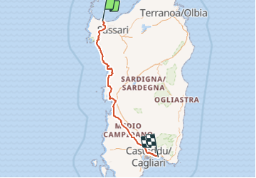
Trail Bicycle tourism of 299 km to be discovered at Sardinia, Sassari, Posthudorra/Porto Torres. This trail is proposed by Mariolebeno.

Description

l'itinéraire a été généré par tronçons grâce à https://cycle.travel/ qui permet de dénicher des petites routes et chemins "carrossables", export gpx pour utilisation dans la foulée avec Sitytrail, un jeu d'enfant
Franchement, nous n'avons pas trouvé grand chose à redire sur les itinéraires proposés, une sortie de propriété agricole un peu scabreuse au dessus des murs de clôture, mais c'est tout.

Elevation profile

Positioning

Country:
Italy
Region :
Sardinia
Department/Province :
Sassari
Municipality :
Posthudorra/Porto Torres
Location:
Unknown
Start:(UTM)
450229 ; 4520577 (32T) N.

Trails nearby

Trail Cycle Posthudorra/Porto Torres - Porto Torres -Torre della Pelosa - Photo
Cycle
egolibre

Cycle

Easy
Posthudorra/Porto Torres, Sardinia, Sassari, Italy
64 km | 71 km-effort
5h 26min
No


Close
My subscriptions