Trail Walking Viroflay - Viroflay-Rive-Gauche Massy-Verrières 26/11/23 - Photo

Viroflay-Rive-Gauche Massy-Verrières 26/11/23

Nos randonnées en Ile de France

© OpenStreetMap contributors
Length
Length
21 km
Max alt
Max alt
187 m
Uphill gradient
Uphill gradient
345 m
Km-Effort
Km-Effort  
26 km
Min alt
Min alt
58 m
Downhill gradient
Downhill gradient
387 m
Boucle
Boucle
No
Creation date :
2023-11-26 08:43:48.429
Updated on :
2023-11-27 09:17:10.478

(0 Reviews)

Walking
Walking
5h50
Difficulty : Medium

Scan this QR Code to open this trail in the SityTrail application

FREE GPS app for hiking

Logo SityTrail SityTrail

IGN / Geographical institutes

Download SityTrail from the App Store Download SityTrail from Google Play

Logo SityTrail SityTrail World

The world is yours!

Download SityTrail from the App Store Download SityTrail from Google Play Download SityTrail on Huawei AppGallery

About

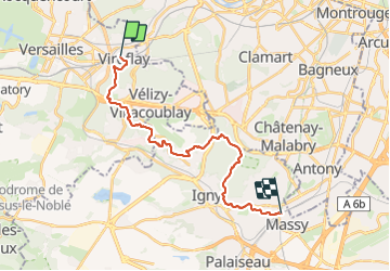
Trail Walking of 21 km to be discovered at Ile-de-France, Yvelines, Viroflay. This trail is proposed by Randonneurs du XIème.

Elevation profile

Positioning

Country:
France
Region :
Ile-de-France
Department/Province :
Yvelines
Municipality :
Viroflay
Location:
Unknown
Start:(UTM)
439151 ; 5405630 (31U) N.

Trails nearby

Trail Walking Chaville - Le Sentier des 7 étangs - Photo
Walking
tracegps

Walking

Difficult
(5)
Chaville, Ile-de-France, Hauts-de-Seine, France
23 km | 31 km-effort
5h 0min
Yes
Trail Walking Chaville - GRP CV-IDF 20R Chaville à Vaucresson - Photo
Walking
clalaur

Walking

Medium
(1)
Chaville, Ile-de-France, Hauts-de-Seine, France
8.2 km | 11.1 km-effort
2h 30min
No
Trail Walking Jouy-en-Josas - GRP CV-IDF 2023 - Photo
Walking
clalaur

Walking

Difficult
(1)
Jouy-en-Josas, Ile-de-France, Yvelines, France
11.2 km | 14.5 km-effort
3h 17min
No
Trail Walking Viroflay - Les 3 Forêts; Meudon, Fausses Reposes et Versailles - Photo
Walking
tracegps

Walking

Difficult
(2)
Viroflay, Ile-de-France, Yvelines, France
25 km | 32 km-effort
5h 19min
Yes
Trail Walking Chaville - Sentier des deux Forêts - Meudon et Verrières - Photo
Walking
tracegps

Walking

Difficult
(2)
Chaville, Ile-de-France, Hauts-de-Seine, France
23 km | 29 km-effort
5h 0min
Yes
Trail Walking Buc - Le Tour de Satory - Photo
Walking
tracegps

Walking

Difficult
(2)
Buc, Ile-de-France, Yvelines, France
23 km | 28 km-effort
4h 49min
Yes
Trail Walking Boulogne-Billancourt - Parc de St Cloud et forêt de Fausses Reposes - Photo
Walking
tracegps

Walking

Medium
(1)
Boulogne-Billancourt, Ile-de-France, Hauts-de-Seine, France
18.2 km | 23 km-effort
4h 30min
No
Trail On foot Boulogne-Billancourt - Boulogne -  Marne la Coquette - Ville d'Avray - Meudon - Photo
On foot
GUIDE
chessyca

On foot

Difficult
Boulogne-Billancourt, Ile-de-France, Hauts-de-Seine, France
29 km | 36 km-effort
8h 9min
No
Trail Walking Versailles - 20240828_100557 - Photo
Walking
GUIDE
chessyca

Walking

Very difficult
Versailles, Ile-de-France, Yvelines, France
19.7 km | 25 km-effort
5h 34min
Yes


Close
My subscriptions