![](/images/other/stat-length.png)
![Trail Walking Gréolières - Greolieres au Cheiron - Photo](https://media.geolcdn.com/t/1900/400/a795c4bb-6c25-4de9-8cde-b16d0eac6c34.jpg&format=pjpeg&maxdim=2)
Greolieres au Cheiron
GrouGary
User
![Length](/images/other/stat-length.png)
![Max alt](https://static1.geolcdn.com/siteimages/upload/files/1508320355ic_sort_altitude_max_24dp.png)
![Uphill gradient](https://static1.geolcdn.com/siteimages/upload/files/1508320355ic_sort_den_pos_24dp.png)
![Km-Effort](/images/other/stat-length.png)
![Min alt](https://static1.geolcdn.com/siteimages/upload/files/1508320355ic_sort_altitude_min_24dp.png)
![Downhill gradient](https://static1.geolcdn.com/siteimages/upload/files/1508320355ic_sort_den_neg_24dp.png)
![Boucle](https://static1.geolcdn.com/siteimages/upload/files/16400158638029165_repeat_loop_refresh_sync_direction_icon.png)
![Walking](https://static1.geolcdn.com/sitytour/trail-icons/101.png)
5h49
Difficulty : Medium
![Scan this QR Code to open this trail in the SityTrail application](https://capi.geolives.com/qq0zvz2zws4bq2lad0pu/sitytour/trails/3876015/qr.png?size=200)
FREE GPS app for hiking
About
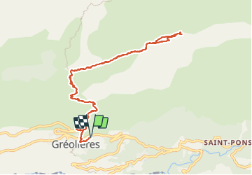
Trail Walking of 12.8 km to be discovered at Provence-Alpes-Côte d'Azur, Maritime Alps, Gréolières. This trail is proposed by GrouGary.
Description
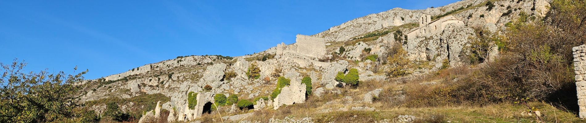
un A/R à partir de l'ancien village de Gréolières où subsistent les murs d'un chateau, d'une ancienne léproserie et surtout la belle chapelle Ste Etienne du 13è siècle.
Village et chateau édifiés sur la hauteur pour se protéger de l'invasion mauresque de l'époque. La principale voie romaine qui reliait Vence à Castellane passait par Gréolières.
1er chateau de Hte Gréolière cité en 1047, détruit puis reconstruit vers 1230 par le Comte de Provence. Agrandi et modifié dans la 2ème moitié du 14è siècle. Abandonné au cours du 15è siècle. Hte Gréolière cesse d'être une paroisse en 1787 mais restera habité jusqu'à la fin du 19è siècle.
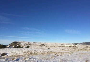
Montée de la rando soutenue mais sans aucune difficulté jusqu'au Collet de Barri puis le Cheiron.
Positioning
Comments
Trails nearby
![Trail Walking Cipières - Cipières Sommet de Calern - Grotte de ND de Calern - Photo](https://media.geolcdn.com/t/375/260/dcc22407-202f-49e5-a220-25d384f38a74.jpg&format=jpg&maxdim=2)
![Walking Walking](https://static1.geolcdn.com/sitytour/trail-icons/101.png)
Walking
![](/images/other/stat-length.png)
![](https://static1.geolcdn.com/siteimages/upload/files/16400158638029165_repeat_loop_refresh_sync_direction_icon.png)
![Trail On foot Cipières - Traversée de l'Estéron - Etape 2 - Photo](https://media.geolcdn.com/t/375/260/ebd4d990-1504-43f1-96fb-3c8749b403dd.jpeg&format=jpg&maxdim=2)
![On foot On foot](https://static1.geolcdn.com/sitytour/trail-icons/100.png)
On foot
![](/images/other/stat-length.png)
![](https://static1.geolcdn.com/siteimages/upload/files/16400158638029165_repeat_loop_refresh_sync_direction_icon.png)
![Trail On foot Cipières - Traversée de l'Estéron - Etape 1 - Photo](https://media.geolcdn.com/t/375/260/0e49d622-3c08-45d7-a080-59d63fc9110b.jpeg&format=jpg&maxdim=2)
![On foot On foot](https://static1.geolcdn.com/sitytour/trail-icons/100.png)
On foot
![](/images/other/stat-length.png)
![](https://static1.geolcdn.com/siteimages/upload/files/16400158638029165_repeat_loop_refresh_sync_direction_icon.png)
![Trail On foot Gréolières - Cime du Cheiron - Photo](https://media.geolcdn.com/t/375/260/273aae50-c65a-44a2-8836-25bdf1d17610.jpeg&format=jpg&maxdim=2)
![On foot On foot](https://static1.geolcdn.com/sitytour/trail-icons/100.png)
On foot
![](/images/other/stat-length.png)
![](https://static1.geolcdn.com/siteimages/upload/files/16400158638029165_repeat_loop_refresh_sync_direction_icon.png)
![Trail On foot Cipières - Plateau de Calern - Photo](https://media.geolcdn.com/t/375/260/04069cc7-0f77-41ab-bace-443cac173cb2.jpeg&format=jpg&maxdim=2)
![On foot On foot](https://static1.geolcdn.com/sitytour/trail-icons/100.png)
On foot
![](/images/other/stat-length.png)
![](https://static1.geolcdn.com/siteimages/upload/files/16400158638029165_repeat_loop_refresh_sync_direction_icon.png)
![Trail On foot Gréolières - Circuit du Loup - Photo](https://media.geolcdn.com/t/375/260/09dfa2b7-7900-471b-b9af-79ed74d6292b.jpeg&format=jpg&maxdim=2)
![On foot On foot](https://static1.geolcdn.com/sitytour/trail-icons/100.png)
On foot
![](/images/other/stat-length.png)
![](https://static1.geolcdn.com/siteimages/upload/files/16400158638029165_repeat_loop_refresh_sync_direction_icon.png)
![Trail On foot Gréolières - Traversée des Miroirs - Photo](https://media.geolcdn.com/t/375/260/273aae50-c65a-44a2-8836-25bdf1d17610.jpeg&format=jpg&maxdim=2)
![On foot On foot](https://static1.geolcdn.com/sitytour/trail-icons/100.png)
On foot
![](/images/other/stat-length.png)
![](https://static1.geolcdn.com/siteimages/upload/files/16400158638029165_repeat_loop_refresh_sync_direction_icon.png)
![Trail Walking Gréolières - Cretes du Cheiron - Photo](https://media.geolcdn.com/t/375/260/88c8f012-b9cc-414c-b278-7a06867d8cc1.jpg&format=jpg&maxdim=2)
![Walking Walking](https://static1.geolcdn.com/sitytour/trail-icons/101.png)
Walking
![](/images/other/stat-length.png)
![](https://static1.geolcdn.com/siteimages/upload/files/16400158638029165_repeat_loop_refresh_sync_direction_icon.png)
![Trail Walking Caussols - Calern - Photo](https://media.geolcdn.com/t/375/260/05a59553-03ef-4163-b36a-14c996b125d5.jpg&format=jpg&maxdim=2)
![Walking Walking](https://static1.geolcdn.com/sitytour/trail-icons/101.png)
Walking
![](/images/other/stat-length.png)
![](https://static1.geolcdn.com/siteimages/upload/files/16400158638029165_repeat_loop_refresh_sync_direction_icon.png)