![](/images/other/stat-length.png)
![Trail Walking Ventron - Chaume des Vintergés et Haut de Felsach - Photo](https://media.geolcdn.com/t/1900/400/ext.pjpeg?maxdim=2&url=https%3A%2F%2Fservices.sitytrail.com%2FGeolivesWS%2FDownloadMedia.ashx%3FTrailID%3D387339%26Media%3Dfix__20150217162609.jpg)
Chaume des Vintergés et Haut de Felsach
jeanclaude12
User
![Length](/images/other/stat-length.png)
Length
7.2 km
![Max alt](https://static1.geolcdn.com/siteimages/upload/files/1508320355ic_sort_altitude_max_24dp.png)
Max alt
1156 m
![Uphill gradient](https://static1.geolcdn.com/siteimages/upload/files/1508320355ic_sort_den_pos_24dp.png)
Uphill gradient
318 m
![Km-Effort](/images/other/stat-length.png)
Km-Effort
11.5 km
![Min alt](https://static1.geolcdn.com/siteimages/upload/files/1508320355ic_sort_altitude_min_24dp.png)
Min alt
895 m
![Downhill gradient](https://static1.geolcdn.com/siteimages/upload/files/1508320355ic_sort_den_neg_24dp.png)
Downhill gradient
322 m
![Boucle](https://static1.geolcdn.com/siteimages/upload/files/16400158638029165_repeat_loop_refresh_sync_direction_icon.png)
Boucle
Yes
Creation date :
2015-02-17 00:00:00.0
Updated on :
2015-02-17 00:00:00.0
![Walking](https://static1.geolcdn.com/sitytour/trail-icons/101.png)
2h51
Difficulty : Medium
![Scan this QR Code to open this trail in the SityTrail application](https://capi.geolives.com/qq0zvz2zws4bq2lad0pu/sitytour/trails/387339/qr.png?size=200)
FREE GPS app for hiking
About
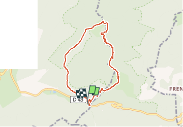
Trail Walking of 7.2 km to be discovered at Grand Est, Vosges, Ventron. This trail is proposed by jeanclaude12.
Description
Au départ du Chalet du Tremplin au Col d'Oderen, la Chaumes des Vintergés est accessible par le dessus du Pré de l'Etang vers le Ruisseau des Vintergés. Le retour se fait par l'Abri Forestier, le Haut de Felsach et la Ferme Auberge de Felsach.
Positioning
Country:
France
Region :
Grand Est
Department/Province :
Vosges
Municipality :
Ventron
Location:
Unknown
Start:(Dec)
Start:(UTM)
344339 ; 5309917 (32T) N.
Comments
Trails nearby
![Trail Walking Kruth - Autour du lac de Kruth-Wildenstein - Photo](https://media.geolcdn.com/t/375/260/c1e79833-f011-4190-a625-acd1b44dc0b0.jpeg&format=jpg&maxdim=2)
![Walking Walking](https://static1.geolcdn.com/sitytour/trail-icons/101.png)
Autour du lac de Kruth-Wildenstein
Walking
Medium
(1)
Kruth,
Grand Est,
Haut-Rhin,
France
![](/images/other/stat-length.png)
7.6 km | 12.7 km-effort
3h 15min
![](https://static1.geolcdn.com/siteimages/upload/files/16400158638029165_repeat_loop_refresh_sync_direction_icon.png)
Yes
![Trail Walking Bussang - Col de Bussang - Rouge Gazon - Séchenat - Photo](https://media.geolcdn.com/t/375/260/ext.jpg?maxdim=2&url=https%3A%2F%2Fservices.sitytrail.com%2FGeolivesWS%2FDownloadMedia.ashx%3FTrailID%3D450013%26Media%3Dfix__20150715145430.jpg)
![Walking Walking](https://static1.geolcdn.com/sitytour/trail-icons/101.png)
Col de Bussang - Rouge Gazon - Séchenat
Walking
Difficult
(1)
Bussang,
Grand Est,
Vosges,
France
![](/images/other/stat-length.png)
15 km | 24 km-effort
6h 0min
![](https://static1.geolcdn.com/siteimages/upload/files/16400158638029165_repeat_loop_refresh_sync_direction_icon.png)
No
![Trail Snowshoes Bussang - Circuit de raquette de Bussang - Photo](https://media.geolcdn.com/t/375/260/ext.jpg?maxdim=2&url=https%3A%2F%2Fservices.sitytrail.com%2FGeolivesWS%2FDownloadMedia.ashx%3FTrailID%3D111638%26Media%3D7873_6.jpg)
![Snowshoes Snowshoes](https://static1.geolcdn.com/sitytour/trail-icons/504.png)
Circuit de raquette de Bussang
Snowshoes
Difficult
(1)
Bussang,
Grand Est,
Vosges,
France
![](/images/other/stat-length.png)
7.7 km | 11.2 km-effort
3h 0min
![](https://static1.geolcdn.com/siteimages/upload/files/16400158638029165_repeat_loop_refresh_sync_direction_icon.png)
Yes
![Trail Walking Ventron - L'Ermitage du Frère Joseph depuis Ventron - Photo](https://media.geolcdn.com/t/375/260/ext.jpg?maxdim=2&url=https%3A%2F%2Fservices.sitytrail.com%2FGeolivesWS%2FDownloadMedia.ashx%3FTrailID%3D665161%26Media%3Dfix__20161126152747.jpg)
![Walking Walking](https://static1.geolcdn.com/sitytour/trail-icons/101.png)
L'Ermitage du Frère Joseph depuis Ventron
Walking
Easy
(1)
Ventron,
Grand Est,
Vosges,
France
![](/images/other/stat-length.png)
10.2 km | 15.4 km-effort
2h 49min
![](https://static1.geolcdn.com/siteimages/upload/files/16400158638029165_repeat_loop_refresh_sync_direction_icon.png)
Yes
![Trail Walking Fellering - Felsach _chapelle ST Nicolas_frenz - Photo](https://media.geolcdn.com/t/375/260/ext.jpg?maxdim=2&url=https%3A%2F%2Fstatic1.geolcdn.com%2Fsiteimages%2Fupload%2Ffiles%2F1553511878bg_sport_marche.png)
![Walking Walking](https://static1.geolcdn.com/sitytour/trail-icons/101.png)
Felsach _chapelle ST Nicolas_frenz
Walking
Difficult
(3)
Fellering,
Grand Est,
Haut-Rhin,
France
![](/images/other/stat-length.png)
9.6 km | 16.5 km-effort
3h 45min
![](https://static1.geolcdn.com/siteimages/upload/files/16400158638029165_repeat_loop_refresh_sync_direction_icon.png)
Yes
![Mountain bike Mountain bike](https://static1.geolcdn.com/sitytour/trail-icons/202.png)
activity_9407679223
Mountain bike
Medium
Bussang,
Grand Est,
Vosges,
France
![](/images/other/stat-length.png)
21 km | 30 km-effort
2h 2min
![](https://static1.geolcdn.com/siteimages/upload/files/16400158638029165_repeat_loop_refresh_sync_direction_icon.png)
Yes
![Trail Walking Ventron - 2022-02-19 Marche Ventron Tête des Champs - Photo](https://media.geolcdn.com/t/375/260/06aadd17-f4b2-4026-a19b-5cf0f11fcd92.jpg&format=jpg&maxdim=2)
![Walking Walking](https://static1.geolcdn.com/sitytour/trail-icons/101.png)
2022-02-19 Marche Ventron Tête des Champs
Walking
Very difficult
Ventron,
Grand Est,
Vosges,
France
![](/images/other/stat-length.png)
22 km | 34 km-effort
5h 52min
![](https://static1.geolcdn.com/siteimages/upload/files/16400158638029165_repeat_loop_refresh_sync_direction_icon.png)
Yes
![Trail On foot Ventron - Circuit de la Croix de l’Hermite par Forgoutte - Photo](https://media.geolcdn.com/t/375/260/d9c2017f-89af-4e26-9799-43d15f74a50f.jpeg&format=jpg&maxdim=2)
![On foot On foot](https://static1.geolcdn.com/sitytour/trail-icons/100.png)
Circuit de la Croix de l’Hermite par Forgoutte
On foot
Easy
Ventron,
Grand Est,
Vosges,
France
![](/images/other/stat-length.png)
4.3 km | 6.6 km-effort
1h 29min
![](https://static1.geolcdn.com/siteimages/upload/files/16400158638029165_repeat_loop_refresh_sync_direction_icon.png)
No
![Trail On foot Ventron - Circuit panoramique de la Futaie - Photo](https://media.geolcdn.com/t/375/260/eb0c45ef-a3eb-4f0d-8469-bf703ef6a7a4.jpeg&format=jpg&maxdim=2)
![On foot On foot](https://static1.geolcdn.com/sitytour/trail-icons/100.png)
Circuit panoramique de la Futaie
On foot
Easy
Ventron,
Grand Est,
Vosges,
France
![](/images/other/stat-length.png)
8.8 km | 12.6 km-effort
2h 52min
![](https://static1.geolcdn.com/siteimages/upload/files/16400158638029165_repeat_loop_refresh_sync_direction_icon.png)
Yes