![](/images/other/stat-length.png)
![Trail Walking Cazedarnes - Cazedarnes - Photo](https://media.geolcdn.com/t/1900/400/9c9420d0-c16f-4f56-a9a1-d3e68160beaa.jpg&format=pjpeg&maxdim=2)
Cazedarnes
Raymond DAVID
User
![Length](/images/other/stat-length.png)
Length
28 km
![Max alt](https://static1.geolcdn.com/siteimages/upload/files/1508320355ic_sort_altitude_max_24dp.png)
Max alt
242 m
![Uphill gradient](https://static1.geolcdn.com/siteimages/upload/files/1508320355ic_sort_den_pos_24dp.png)
Uphill gradient
440 m
![Km-Effort](/images/other/stat-length.png)
Km-Effort
34 km
![Min alt](https://static1.geolcdn.com/siteimages/upload/files/1508320355ic_sort_altitude_min_24dp.png)
Min alt
44 m
![Downhill gradient](https://static1.geolcdn.com/siteimages/upload/files/1508320355ic_sort_den_neg_24dp.png)
Downhill gradient
545 m
![Boucle](https://static1.geolcdn.com/siteimages/upload/files/16400158638029165_repeat_loop_refresh_sync_direction_icon.png)
Boucle
No
Creation date :
2023-11-19 08:06:00.728
Updated on :
2023-11-19 17:13:27.251
![Walking](https://static1.geolcdn.com/sitytour/trail-icons/101.png)
6h13
Difficulty : Easy
![Scan this QR Code to open this trail in the SityTrail application](https://capi.geolives.com/qq0zvz2zws4bq2lad0pu/sitytour/trails/3871452/qr.png?size=200)
FREE GPS app for hiking
About
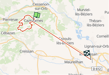
Trail Walking of 28 km to be discovered at Occitania, Hérault, Cazedarnes. This trail is proposed by Raymond DAVID .
Description
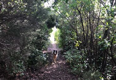
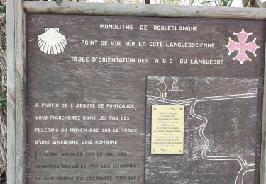
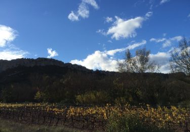
Parking devant l'école. Randonnée agréable à éviter en été. De belles vues, les ruines de Saint-Baulery méritent une visite (chapelle, pigeonnier et bâtiments). Une descente un peu difficile en fin de matinée.
Positioning
Country:
France
Region :
Occitania
Department/Province :
Hérault
Municipality :
Cazedarnes
Location:
Unknown
Start:(Dec)
Start:(UTM)
502248 ; 4807823 (31T) N.
Comments
Trails nearby
![Trail Walking Cessenon-sur-Orb - Cessenon Rives de l'Orb - Photo](https://media.geolcdn.com/t/375/260/ext.jpg?maxdim=2&url=https%3A%2F%2Fservices.sitytrail.com%2FGeolivesWS%2FDownloadMedia.ashx%3FTrailID%3D169953%26Media%3D04af9e60-af3a-487e-abf0-9064e60910a7.jpg)
![Walking Walking](https://static1.geolcdn.com/sitytour/trail-icons/101.png)
Cessenon Rives de l'Orb
Walking
Easy
(2)
Cessenon-sur-Orb,
Occitania,
Hérault,
France
![](/images/other/stat-length.png)
12.5 km | 14.4 km-effort
3h 11min
![](https://static1.geolcdn.com/siteimages/upload/files/16400158638029165_repeat_loop_refresh_sync_direction_icon.png)
Yes
![Trail Walking Cessenon-sur-Orb - Cazedarnes - Photo](https://media.geolcdn.com/t/375/260/574453d5-3d97-47ba-9d9c-a32eb93af3e0.jpg&format=jpg&maxdim=2)
![Walking Walking](https://static1.geolcdn.com/sitytour/trail-icons/101.png)
Cazedarnes
Walking
Easy
Cessenon-sur-Orb,
Occitania,
Hérault,
France
![](/images/other/stat-length.png)
14 km | 18.6 km-effort
4h 30min
![](https://static1.geolcdn.com/siteimages/upload/files/16400158638029165_repeat_loop_refresh_sync_direction_icon.png)
Yes
![Trail Walking Prades-sur-Vernazobre - Prades-Broutelade - Photo](https://media.geolcdn.com/t/375/260/4daed71b-0260-47ea-8429-8a6b67508fa4.jpg&format=jpg&maxdim=2)
![Walking Walking](https://static1.geolcdn.com/sitytour/trail-icons/101.png)
Prades-Broutelade
Walking
Easy
(1)
Prades-sur-Vernazobre,
Occitania,
Hérault,
France
![](/images/other/stat-length.png)
13.6 km | 17.5 km-effort
4h 30min
![](https://static1.geolcdn.com/siteimages/upload/files/16400158638029165_repeat_loop_refresh_sync_direction_icon.png)
No
![Trail Walking Prades-sur-Vernazobre - Prades sur vernazobres - Photo](https://media.geolcdn.com/t/375/260/ext.jpg?maxdim=2&url=https%3A%2F%2Fservices.sitytrail.com%2FGeolivesWS%2FDownloadMedia.ashx%3FTrailID%3D922044%26Media%3D20180313092227.jpg)
![Walking Walking](https://static1.geolcdn.com/sitytour/trail-icons/101.png)
Prades sur vernazobres
Walking
Easy
(1)
Prades-sur-Vernazobre,
Occitania,
Hérault,
France
![](/images/other/stat-length.png)
10.3 km | 14.1 km-effort
2h 59min
![](https://static1.geolcdn.com/siteimages/upload/files/16400158638029165_repeat_loop_refresh_sync_direction_icon.png)
Yes
![Trail Walking Cazedarnes - TBG - ACAD - Abbaye de Fontcaude - Trace finale - Photo](https://media.geolcdn.com/t/375/260/1184b9ef-5cef-4713-bb02-d9b321b63d9d.jpg&format=jpg&maxdim=2)
![Walking Walking](https://static1.geolcdn.com/sitytour/trail-icons/101.png)
TBG - ACAD - Abbaye de Fontcaude - Trace finale
Walking
Very difficult
(1)
Cazedarnes,
Occitania,
Hérault,
France
![](/images/other/stat-length.png)
19.6 km | 25 km-effort
5h 39min
![](https://static1.geolcdn.com/siteimages/upload/files/16400158638029165_repeat_loop_refresh_sync_direction_icon.png)
Yes
![Trail Walking Cazedarnes - cazerdane 2 - Photo](https://media.geolcdn.com/t/375/260/ext.jpg?maxdim=2&url=https%3A%2F%2Fservices.sitytrail.com%2FGeolivesWS%2FDownloadMedia.ashx%3FTrailID%3D363046%26Media%3D20141116105914.jpg)
![Walking Walking](https://static1.geolcdn.com/sitytour/trail-icons/101.png)
cazerdane 2
Walking
Very easy
Cazedarnes,
Occitania,
Hérault,
France
![](/images/other/stat-length.png)
9.4 km | 11.6 km-effort
2h 25min
![](https://static1.geolcdn.com/siteimages/upload/files/16400158638029165_repeat_loop_refresh_sync_direction_icon.png)
Yes
![Trail Walking Cazedarnes - Abbaye de Fontcaude - Cazedarnes - Photo](https://media.geolcdn.com/t/375/260/ext.jpg?maxdim=2&url=https%3A%2F%2Fservices.sitytrail.com%2FGeolivesWS%2FDownloadMedia.ashx%3FTrailID%3D110168%26Media%3D5368_1.jpg)
![Walking Walking](https://static1.geolcdn.com/sitytour/trail-icons/101.png)
Abbaye de Fontcaude - Cazedarnes
Walking
Medium
Cazedarnes,
Occitania,
Hérault,
France
![](/images/other/stat-length.png)
7 km | 7.9 km-effort
2h 0min
![](https://static1.geolcdn.com/siteimages/upload/files/16400158638029165_repeat_loop_refresh_sync_direction_icon.png)
Yes
![Trail Walking Pierrerue - pierrerue un tour - Photo](https://media.geolcdn.com/t/375/260/ext.jpg?maxdim=2&url=https%3A%2F%2Fstatic1.geolcdn.com%2Fsiteimages%2Fupload%2Ffiles%2F1553511878bg_sport_marche.png)
![Walking Walking](https://static1.geolcdn.com/sitytour/trail-icons/101.png)
pierrerue un tour
Walking
Medium
Pierrerue,
Occitania,
Hérault,
France
![](/images/other/stat-length.png)
8.1 km | 10.4 km-effort
2h 19min
![](https://static1.geolcdn.com/siteimages/upload/files/16400158638029165_repeat_loop_refresh_sync_direction_icon.png)
Yes
![Trail Walking Cessenon-sur-Orb - cessenon petit tour - Photo](https://media.geolcdn.com/t/375/260/ext.jpg?maxdim=2&url=https%3A%2F%2Fstatic1.geolcdn.com%2Fsiteimages%2Fupload%2Ffiles%2F1553511878bg_sport_marche.png)
![Walking Walking](https://static1.geolcdn.com/sitytour/trail-icons/101.png)
cessenon petit tour
Walking
Medium
Cessenon-sur-Orb,
Occitania,
Hérault,
France
![](/images/other/stat-length.png)
8.3 km | 10.1 km-effort
2h 41min
![](https://static1.geolcdn.com/siteimages/upload/files/16400158638029165_repeat_loop_refresh_sync_direction_icon.png)
No