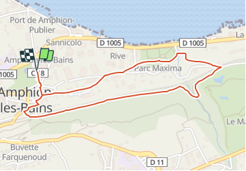
![](/images/other/stat-length.png)
![Trail Walking Publier - Amphion les Bains - Parc Maxima et chemin au dessus de la voie ferrée - Photo](https://media.geolcdn.com/t/1900/400/ext.pjpeg?maxdim=2&url=https%3A%2F%2Fstatic1.geolcdn.com%2Fsiteimages%2Fupload%2Ffiles%2F1553511878bg_sport_marche.png)
Amphion les Bains - Parc Maxima et chemin au dessus de la voie ferrée
Marie-Claire-mcp
User
![Length](/images/other/stat-length.png)
![Max alt](https://static1.geolcdn.com/siteimages/upload/files/1508320355ic_sort_altitude_max_24dp.png)
![Uphill gradient](https://static1.geolcdn.com/siteimages/upload/files/1508320355ic_sort_den_pos_24dp.png)
![Km-Effort](/images/other/stat-length.png)
![Min alt](https://static1.geolcdn.com/siteimages/upload/files/1508320355ic_sort_altitude_min_24dp.png)
![Downhill gradient](https://static1.geolcdn.com/siteimages/upload/files/1508320355ic_sort_den_neg_24dp.png)
![Boucle](https://static1.geolcdn.com/siteimages/upload/files/16400158638029165_repeat_loop_refresh_sync_direction_icon.png)
![Walking](https://static1.geolcdn.com/sitytour/trail-icons/101.png)
45m
Difficulty : Easy
![Scan this QR Code to open this trail in the SityTrail application](https://capi.geolives.com/qq0zvz2zws4bq2lad0pu/sitytour/trails/3864641/qr.png?size=200)
FREE GPS app for hiking
About
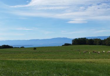
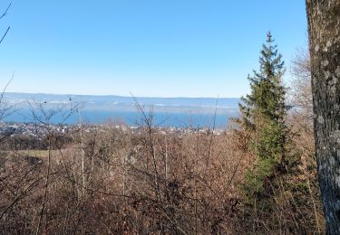
Trail Walking of 2.5 km to be discovered at Auvergne-Rhône-Alpes, Upper Savoy, Publier. This trail is proposed by Marie-Claire-mcp.
Description
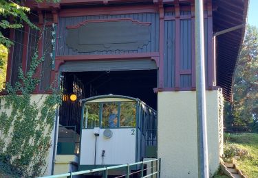
Parking super U à Amphion les Bains - rue de la source puis traverser le Parc Maxima, prendre le chemin à coté de la maison bleu jusqu'à la voie ferrée, la traversée et prendre le chemin à droite, longer la voie ferrée (on peut également prendre à gauche à la rivière et passer le pont pour arriver en haut du bois où il y a la station d'eau de Thonon) et ressortir par un escalier qui passe sous la voie ferrée et ressort dans le vieux village.
Positioning
Comments
Trails nearby
![Trail Mountain bike Publier - VTT Bois de Ville Carriere - Photo](https://media.geolcdn.com/t/375/260/ext.jpg?maxdim=2&url=https%3A%2F%2Fstatic1.geolcdn.com%2Fsiteimages%2Fupload%2Ffiles%2F1524743154velo.jpg)
![Mountain bike Mountain bike](https://static1.geolcdn.com/sitytour/trail-icons/202.png)
Mountain bike
![](/images/other/stat-length.png)
![](https://static1.geolcdn.com/siteimages/upload/files/16400158638029165_repeat_loop_refresh_sync_direction_icon.png)
![Trail Walking Thonon-les-Bains - Rando Thonon - Photo](https://media.geolcdn.com/t/375/260/045d2246-16a3-4fb9-a5e7-5b0993d8eaf7.jpg&format=jpg&maxdim=2)
![Walking Walking](https://static1.geolcdn.com/sitytour/trail-icons/101.png)
Walking
![](/images/other/stat-length.png)
![](https://static1.geolcdn.com/siteimages/upload/files/16400158638029165_repeat_loop_refresh_sync_direction_icon.png)
![Trail On foot Thonon-les-Bains - GRP Littoral du Léman - Photo](https://media.geolcdn.com/t/375/260/08b05c77-4d18-4df6-9472-d5271b5e1471.jpeg&format=jpg&maxdim=2)
![On foot On foot](https://static1.geolcdn.com/sitytour/trail-icons/100.png)
On foot
![](/images/other/stat-length.png)
![](https://static1.geolcdn.com/siteimages/upload/files/16400158638029165_repeat_loop_refresh_sync_direction_icon.png)
![Trail Walking Marin - Morel aux vignes - Photo](https://media.geolcdn.com/t/375/260/75d9e7d6-5d89-4a3a-adbd-58ad391eb8c0.jpg&format=jpg&maxdim=2)
![Walking Walking](https://static1.geolcdn.com/sitytour/trail-icons/101.png)
Walking
![](/images/other/stat-length.png)
![](https://static1.geolcdn.com/siteimages/upload/files/16400158638029165_repeat_loop_refresh_sync_direction_icon.png)
![Trail Motorbike Thonon-les-Bains - GTA 2018 - ETAPE 2 - Photo](https://media.geolcdn.com/t/375/260/f293979c-6770-41e2-a588-185da9cd4036.jpg&format=jpg&maxdim=2)
![Motorbike Motorbike](https://static1.geolcdn.com/sitytour/trail-icons/402.png)
Motorbike
![](/images/other/stat-length.png)
![](https://static1.geolcdn.com/siteimages/upload/files/16400158638029165_repeat_loop_refresh_sync_direction_icon.png)
![Trail Cycle Thonon-les-Bains - col du feu - Photo](https://media.geolcdn.com/t/375/260/ext.jpg?maxdim=2&url=https%3A%2F%2Fservices.sitytrail.com%2FGeolivesWS%2FDownloadMedia.ashx%3FTrailID%3D220539%26Media%3Dfix__20130911131210.jpg)
![Cycle Cycle](https://static1.geolcdn.com/sitytour/trail-icons/200.png)
Cycle
![](/images/other/stat-length.png)
![](https://static1.geolcdn.com/siteimages/upload/files/16400158638029165_repeat_loop_refresh_sync_direction_icon.png)
![Trail Walking Féternes - feternes - Photo](https://media.geolcdn.com/t/375/260/08f06a13-c293-4e3f-97ab-27cbef42d4e6.jpg&format=jpg&maxdim=2)
![Walking Walking](https://static1.geolcdn.com/sitytour/trail-icons/101.png)
Walking
![](/images/other/stat-length.png)
![](https://static1.geolcdn.com/siteimages/upload/files/16400158638029165_repeat_loop_refresh_sync_direction_icon.png)
![Trail Walking Thonon-les-Bains - La fontaine couverte - Photo](https://media.geolcdn.com/t/375/260/f0fc9f05-8614-49f0-819b-fd232b9ab161.jpg&format=jpg&maxdim=2)
![Walking Walking](https://static1.geolcdn.com/sitytour/trail-icons/101.png)
Walking
![](/images/other/stat-length.png)
![](https://static1.geolcdn.com/siteimages/upload/files/16400158638029165_repeat_loop_refresh_sync_direction_icon.png)
![Trail Walking Évian-les-Bains - balade découverte Evians Neuvecelle - Photo](https://media.geolcdn.com/t/375/260/d44dc155-48cc-4fb2-abf4-45399839dc79.jpg&format=jpg&maxdim=2)
![Walking Walking](https://static1.geolcdn.com/sitytour/trail-icons/101.png)
Walking
![](/images/other/stat-length.png)
![](https://static1.geolcdn.com/siteimages/upload/files/16400158638029165_repeat_loop_refresh_sync_direction_icon.png)