![](/images/other/stat-length.png)
![Trail Walking St. Märgen - Cascade Zweribach depuis Sankt Märgen - Photo](https://media.geolcdn.com/t/1900/400/8d3668c9-80d9-43fe-b159-197c8fd8732f.jpg&format=pjpeg&maxdim=2)
Cascade Zweribach depuis Sankt Märgen
Bart2015
User
![Length](/images/other/stat-length.png)
![Max alt](https://static1.geolcdn.com/siteimages/upload/files/1508320355ic_sort_altitude_max_24dp.png)
![Uphill gradient](https://static1.geolcdn.com/siteimages/upload/files/1508320355ic_sort_den_pos_24dp.png)
![Km-Effort](/images/other/stat-length.png)
![Min alt](https://static1.geolcdn.com/siteimages/upload/files/1508320355ic_sort_altitude_min_24dp.png)
![Downhill gradient](https://static1.geolcdn.com/siteimages/upload/files/1508320355ic_sort_den_neg_24dp.png)
![Boucle](https://static1.geolcdn.com/siteimages/upload/files/16400158638029165_repeat_loop_refresh_sync_direction_icon.png)
![Walking](https://static1.geolcdn.com/sitytour/trail-icons/101.png)
5h09
Difficulty : Very difficult
![Scan this QR Code to open this trail in the SityTrail application](https://capi.geolives.com/qq0zvz2zws4bq2lad0pu/sitytour/trails/3863916/qr.png?size=200)
FREE GPS app for hiking
About
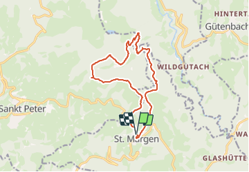
Trail Walking of 15 km to be discovered at Baden-Württemberg, Landkreis Breisgau-Hochschwarzwald, St. Märgen. This trail is proposed by Bart2015.
Description
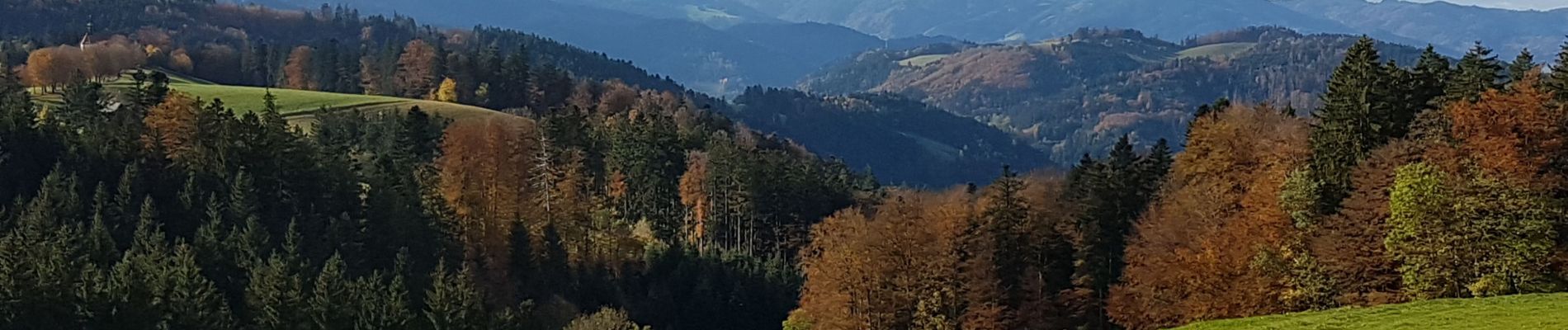
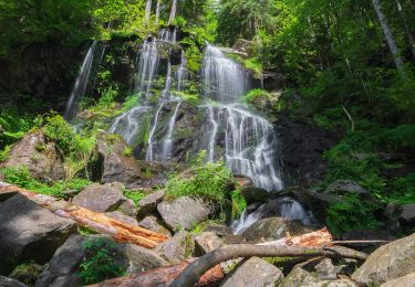
Très belle randonnée qui nous emmène au travers de forêts immenses à la découverte d'une cascade qui ravira tous les amoureux des beautés de la nature. Les photos parlent d'elles même ... Les paysages montagnards sont splendides, les découvrir en automne, que du bonheur ...
Bonne et belle rando ...
PS : bonnes chaussures indispensables, surtout si les sentiers sont humides.
Positioning
Comments
Trails nearby
![Trail On foot St. Märgen - DE-Habstmoos - Bannwald Zweribach - Photo](https://media.geolcdn.com/t/375/260/643c08f1-48c7-4bd5-bbc7-fddc0a235ea5.jpeg&format=jpg&maxdim=2)
![On foot On foot](https://static1.geolcdn.com/sitytour/trail-icons/100.png)
On foot
![](/images/other/stat-length.png)
![](https://static1.geolcdn.com/siteimages/upload/files/16400158638029165_repeat_loop_refresh_sync_direction_icon.png)
![Trail Cycle Sankt Peter - st peter donauschlingen - Photo](https://media.geolcdn.com/t/375/260/ext.jpg?maxdim=2&url=https%3A%2F%2Fstatic1.geolcdn.com%2Fsiteimages%2Fupload%2Ffiles%2F1524743154velo.jpg)
![Cycle Cycle](https://static1.geolcdn.com/sitytour/trail-icons/200.png)
Cycle
![](/images/other/stat-length.png)
![](https://static1.geolcdn.com/siteimages/upload/files/16400158638029165_repeat_loop_refresh_sync_direction_icon.png)
![Trail Motor Sankt Peter - route des coucous - Photo](https://media.geolcdn.com/t/375/260/ext.jpg?maxdim=2&url=https%3A%2F%2Fstatic1.geolcdn.com%2Fsiteimages%2Fupload%2Ffiles%2F15247431544x4.jpg)
![Motor Motor](https://static1.geolcdn.com/sitytour/trail-icons/400.png)
Motor
![](/images/other/stat-length.png)
![](https://static1.geolcdn.com/siteimages/upload/files/16400158638029165_repeat_loop_refresh_sync_direction_icon.png)