Trail Walking Chugchillan - Chugchillan - Quilotoa - Photo

Chugchillan - Quilotoa

 mpignon
mpignon

User

© OpenStreetMap contributors
Length
Length
13.4 km
Max alt
Max alt
3881 m
Uphill gradient
Uphill gradient
1143 m
Km-Effort
Km-Effort  
27 km
Min alt
Min alt
2960 m
Downhill gradient
Downhill gradient
618 m
Boucle
Boucle
No
Creation date :
2023-11-10 13:32:48.979
Updated on :
2023-11-10 21:41:14.216

(0 Reviews)

Walking
Walking
7h33
Difficulty : Very difficult

Scan this QR Code to open this trail in the SityTrail application

FREE GPS app for hiking

Logo SityTrail SityTrail

IGN / Geographical institutes

Download SityTrail from the App Store Download SityTrail from Google Play

Logo SityTrail SityTrail World

The world is yours!

Download SityTrail from the App Store Download SityTrail from Google Play Download SityTrail on Huawei AppGallery

About

Trail Walking of 13.4 km to be discovered at Cotopaxi, Sigchos, Chugchillan. This trail is proposed by mpignon.

Elevation profile

Positioning

Country:
Ecuador
Region :
Cotopaxi
Department/Province :
Sigchos
Municipality :
Chugchillan
Location:
Unknown
Start:(UTM)
731308 ; 9911290 (17M) S.

Trails nearby

Trail Walking Chugchillan - Sigchos - Quilotoa - Day 3 (chugchilan - Quilotoa) - Photo
Walking
gildascb

Walking

Very difficult
Chugchillan, Cotopaxi, Sigchos, Ecuador
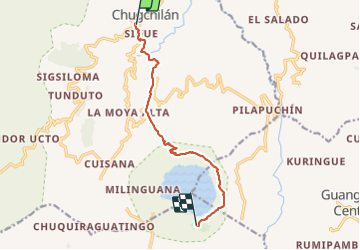
12.8 km | 25 km-effort
6h 4min
No


Close
My subscriptions