![](/images/other/stat-length.png)
![Trail Walking Écuisses - Les étangs de Montchanin et Berthaud - Photo](https://media.geolcdn.com/t/1900/400/ext.pjpeg?maxdim=2&url=https%3A%2F%2Fstatic1.geolcdn.com%2Fsiteimages%2Fupload%2Ffiles%2F1553511878bg_sport_marche.png)
Les étangs de Montchanin et Berthaud
PASSION RANDO
Marcher en groupe en veillant au respect de chacun et à la bonne humeur.
![Length](/images/other/stat-length.png)
Length
10 km
![Max alt](https://static1.geolcdn.com/siteimages/upload/files/1508320355ic_sort_altitude_max_24dp.png)
Max alt
354 m
![Uphill gradient](https://static1.geolcdn.com/siteimages/upload/files/1508320355ic_sort_den_pos_24dp.png)
Uphill gradient
114 m
![Km-Effort](/images/other/stat-length.png)
Km-Effort
11.5 km
![Min alt](https://static1.geolcdn.com/siteimages/upload/files/1508320355ic_sort_altitude_min_24dp.png)
Min alt
295 m
![Downhill gradient](https://static1.geolcdn.com/siteimages/upload/files/1508320355ic_sort_den_neg_24dp.png)
Downhill gradient
114 m
![Boucle](https://static1.geolcdn.com/siteimages/upload/files/16400158638029165_repeat_loop_refresh_sync_direction_icon.png)
Boucle
Yes
Creation date :
2023-11-08 09:29:45.069
Updated on :
2023-11-24 08:15:51.524
![Walking](https://static1.geolcdn.com/sitytour/trail-icons/101.png)
2h37
Difficulty : Medium
![Scan this QR Code to open this trail in the SityTrail application](https://capi.geolives.com/qq0zvz2zws4bq2lad0pu/sitytour/trails/3861371/qr.png?size=200)
FREE GPS app for hiking
About
Trail Walking of 10 km to be discovered at Bourgogne-Franche-Comté, Saône-et-Loire, Écuisses. This trail is proposed by PASSION RANDO.
Description
circuit A/R
départ allée des soupirs parking à droite après le pont Jeanne Rose face à l'auberge du Pont
prendre le chemin à droite le long du canal
Positioning
Country:
France
Region :
Bourgogne-Franche-Comté
Department/Province :
Saône-et-Loire
Municipality :
Écuisses
Location:
Unknown
Start:(Dec)
Start:(UTM)
614267 ; 5177916 (31T) N.
Comments
Trails nearby
![Trail Walking Écuisses - Ecuisses - Photo](https://media.geolcdn.com/t/375/260/f2889d00-007f-4702-87f7-cdfee6d47409.jpg&format=jpg&maxdim=2)
![Walking Walking](https://static1.geolcdn.com/sitytour/trail-icons/101.png)
Ecuisses
Walking
Medium
Écuisses,
Bourgogne-Franche-Comté,
Saône-et-Loire,
France
![](/images/other/stat-length.png)
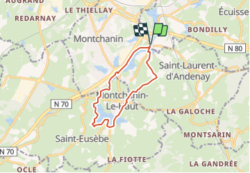
13.1 km | 17 km-effort
3h 14min
![](https://static1.geolcdn.com/siteimages/upload/files/16400158638029165_repeat_loop_refresh_sync_direction_icon.png)
No
![Trail sport Écuisses - Au départ de l'auberge du pont Jeanne-Rose - Photo](https://media.geolcdn.com/t/375/260/9e841c1e-0522-415c-8e21-f80d882cd42a.jpg&format=jpg&maxdim=2)
Au départ de l'auberge du pont Jeanne-Rose
sport
Very easy
(1)
Écuisses,
Bourgogne-Franche-Comté,
Saône-et-Loire,
France
![](/images/other/stat-length.png)
8.4 km | 10.1 km-effort
Unknown
![](https://static1.geolcdn.com/siteimages/upload/files/16400158638029165_repeat_loop_refresh_sync_direction_icon.png)
Yes
![Trail Walking Écuisses - test montchanin - Photo](https://media.geolcdn.com/t/375/260/240f8dd8-309d-4378-a18a-d0bb40888a37.jpg&format=jpg&maxdim=2)
![Walking Walking](https://static1.geolcdn.com/sitytour/trail-icons/101.png)
test montchanin
Walking
Medium
Écuisses,
Bourgogne-Franche-Comté,
Saône-et-Loire,
France
![](/images/other/stat-length.png)
10.2 km | 11.7 km-effort
2h 39min
![](https://static1.geolcdn.com/siteimages/upload/files/16400158638029165_repeat_loop_refresh_sync_direction_icon.png)
Yes
![Trail Walking Écuisses - Ecuisses - Photo](https://media.geolcdn.com/t/375/260/bb329b99-480b-4b48-aa1b-3a7861a27fa0.jpg&format=jpg&maxdim=2)
![Walking Walking](https://static1.geolcdn.com/sitytour/trail-icons/101.png)
Ecuisses
Walking
Difficult
Écuisses,
Bourgogne-Franche-Comté,
Saône-et-Loire,
France
![](/images/other/stat-length.png)
23 km | 30 km-effort
4h 52min
![](https://static1.geolcdn.com/siteimages/upload/files/16400158638029165_repeat_loop_refresh_sync_direction_icon.png)
Yes
![Trail On foot Marcilly-lès-Buxy - Les Trois Auberges - Photo](https://media.geolcdn.com/t/375/260/ext.jpg?maxdim=2&url=https%3A%2F%2Fstatic1.geolcdn.com%2Fsiteimages%2Fupload%2Ffiles%2F1545311037marcheuse_200dpi.jpg)
![On foot On foot](https://static1.geolcdn.com/sitytour/trail-icons/100.png)
Les Trois Auberges
On foot
Easy
Marcilly-lès-Buxy,
Bourgogne-Franche-Comté,
Saône-et-Loire,
France
![](/images/other/stat-length.png)
15.1 km | 19.5 km-effort
4h 26min
![](https://static1.geolcdn.com/siteimages/upload/files/16400158638029165_repeat_loop_refresh_sync_direction_icon.png)
Yes
![Trail Walking Écuisses - AF001Berthaud - Photo](https://media.geolcdn.com/t/375/260/ext.jpg?maxdim=2&url=https%3A%2F%2Fservices.sitytrail.com%2FGeolivesWS%2FDownloadMedia.ashx%3FTrailID%3D827670%26Media%3D20170812113102.jpg)
![Walking Walking](https://static1.geolcdn.com/sitytour/trail-icons/101.png)
AF001Berthaud
Walking
Very easy
Écuisses,
Bourgogne-Franche-Comté,
Saône-et-Loire,
France
![](/images/other/stat-length.png)
16.4 km | 18.1 km-effort
3h 30min
![](https://static1.geolcdn.com/siteimages/upload/files/16400158638029165_repeat_loop_refresh_sync_direction_icon.png)
Yes
![Trail On foot Montchanin - Montchanin - Photo](https://media.geolcdn.com/t/375/260/ext.jpg?maxdim=2&url=https%3A%2F%2Fstatic1.geolcdn.com%2Fsiteimages%2Fupload%2Ffiles%2F1545311037marcheuse_200dpi.jpg)
![On foot On foot](https://static1.geolcdn.com/sitytour/trail-icons/100.png)
Montchanin
On foot
Easy
Montchanin,
Bourgogne-Franche-Comté,
Saône-et-Loire,
France
![](/images/other/stat-length.png)
5 km | 5.5 km-effort
1h 15min
![](https://static1.geolcdn.com/siteimages/upload/files/16400158638029165_repeat_loop_refresh_sync_direction_icon.png)
Yes
![Trail Walking Écuisses - Pont jeanne-rose - La Galoche - St Laurent d'Andenay - Photo](https://media.geolcdn.com/t/375/260/ext.jpg?maxdim=2&url=https%3A%2F%2Fstatic1.geolcdn.com%2Fsiteimages%2Fupload%2Ffiles%2F1553511878bg_sport_marche.png)
![Walking Walking](https://static1.geolcdn.com/sitytour/trail-icons/101.png)
Pont jeanne-rose - La Galoche - St Laurent d'Andenay
Walking
Difficult
Écuisses,
Bourgogne-Franche-Comté,
Saône-et-Loire,
France
![](/images/other/stat-length.png)
11.8 km | 13.7 km-effort
3h 6min
![](https://static1.geolcdn.com/siteimages/upload/files/16400158638029165_repeat_loop_refresh_sync_direction_icon.png)
Yes
![Trail Walking Écuisses - Auberge pont J.Rose - Photo](https://media.geolcdn.com/t/375/260/ext.jpg?maxdim=2&url=https%3A%2F%2Fstatic1.geolcdn.com%2Fsiteimages%2Fupload%2Ffiles%2F1553511878bg_sport_marche.png)
![Walking Walking](https://static1.geolcdn.com/sitytour/trail-icons/101.png)
Auberge pont J.Rose
Walking
Medium
Écuisses,
Bourgogne-Franche-Comté,
Saône-et-Loire,
France
![](/images/other/stat-length.png)
7.2 km | 8.8 km-effort
1h 48min
![](https://static1.geolcdn.com/siteimages/upload/files/16400158638029165_repeat_loop_refresh_sync_direction_icon.png)
Yes