Trail On foot Achery - Achery , Fort de Mayot , Mayot - Photo

Achery , Fort de Mayot , Mayot

 José800
José800

User

© OpenStreetMap contributors
Length
Length
11.3 km
Max alt
Max alt
108 m
Uphill gradient
Uphill gradient
103 m
Km-Effort
Km-Effort  
12.7 km
Min alt
Min alt
53 m
Downhill gradient
Downhill gradient
102 m
Boucle
Boucle
Yes
Creation date :
2023-10-29 22:50:13.116
Updated on :
2023-10-29 22:59:20.922

(0 Reviews)

On foot
On foot
2h52
Difficulty : Easy

Scan this QR Code to open this trail in the SityTrail application

FREE GPS app for hiking

Logo SityTrail SityTrail

IGN / Geographical institutes

Download SityTrail from the App Store Download SityTrail from Google Play

Logo SityTrail SityTrail World

The world is yours!

Download SityTrail from the App Store Download SityTrail from Google Play Download SityTrail on Huawei AppGallery

About

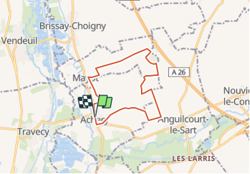
Trail On foot of 11.3 km to be discovered at Hauts-de-France, Aisne, Achery. This trail is proposed by José800.

Description

un beau circuit dans la campagne en direction du fort de Mayot 02  , ancien site militaire méconnu construit il y a 140 ans . un très beau panorama du paysage .

Elevation profile

Positioning

Country:
France
Region :
Hauts-de-France
Department/Province :
Aisne
Municipality :
Achery
Location:
Unknown
Start:(UTM)
528156 ; 5504460 (31U) N.

Trails nearby

Trail Walking Anguilcourt-le-Sart - Anguilecourt le Sart - Photo
Walking
José800

Walking

Easy
Anguilcourt-le-Sart, Hauts-de-France, Aisne, France
9.3 km | 10.6 km-effort
3h 33min
Yes
Trail Walking Vendeuil - Ve.deil Septvaux VF - Photo
Walking
MERMOZ33

Walking

Medium
Vendeuil, Hauts-de-France, Aisne, France
24 km | 28 km-effort
6h 49min
No


Close
My subscriptions