![](/images/other/stat-length.png)
![Trail Walking Pompogne - Pompogne / Auba - Photo](https://media.geolcdn.com/t/1900/400/ext.pjpeg?maxdim=2&url=https%3A%2F%2Fstatic1.geolcdn.com%2Fsiteimages%2Fupload%2Ffiles%2F1553511878bg_sport_marche.png)
Pompogne / Auba
Elbe
User
![Length](/images/other/stat-length.png)
Length
12.3 km
![Max alt](https://static1.geolcdn.com/siteimages/upload/files/1508320355ic_sort_altitude_max_24dp.png)
Max alt
143 m
![Uphill gradient](https://static1.geolcdn.com/siteimages/upload/files/1508320355ic_sort_den_pos_24dp.png)
Uphill gradient
129 m
![Km-Effort](/images/other/stat-length.png)
Km-Effort
14 km
![Min alt](https://static1.geolcdn.com/siteimages/upload/files/1508320355ic_sort_altitude_min_24dp.png)
Min alt
91 m
![Downhill gradient](https://static1.geolcdn.com/siteimages/upload/files/1508320355ic_sort_den_neg_24dp.png)
Downhill gradient
131 m
![Boucle](https://static1.geolcdn.com/siteimages/upload/files/16400158638029165_repeat_loop_refresh_sync_direction_icon.png)
Boucle
Yes
Creation date :
2015-02-11 00:00:00.0
Updated on :
2015-02-11 00:00:00.0
![Walking](https://static1.geolcdn.com/sitytour/trail-icons/101.png)
3h04
Difficulty : Unknown
![Scan this QR Code to open this trail in the SityTrail application](https://capi.geolives.com/qq0zvz2zws4bq2lad0pu/sitytour/trails/385328/qr.png?size=200)
FREE GPS app for hiking
About
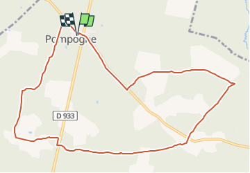
Trail Walking of 12.3 km to be discovered at New Aquitaine, Lot-et-Garonne, Pompogne. This trail is proposed by Elbe.
Description
Pompogne, le clocher et le pin (12,3 Km)
Vous stationnez place de la mairie.
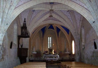
Le pin se plaît dans les sables de la forêt landaise. Il y pousse spontanément. L'un, égaré, s'est agrippé sur le clocher-mur de l'église fortifiée de Pompogne, rappel de l'omniprésence de l'arbre en ce lieu.
Positioning
Country:
France
Region :
New Aquitaine
Department/Province :
Lot-et-Garonne
Municipality :
Pompogne
Location:
Unknown
Start:(Dec)
Start:(UTM)
264624 ; 4904453 (31T) N.
Comments
Trails nearby
![Trail On foot Sauméjan - Sauméjan, vacances au « milieu de la forêt » - 9.9 km - Photo](https://media.geolcdn.com/t/375/260/7e8ffff5-1db4-4879-93a3-100007b84c67.jpeg&format=jpg&maxdim=2)
![On foot On foot](https://static1.geolcdn.com/sitytour/trail-icons/100.png)
Sauméjan, vacances au « milieu de la forêt » - 9.9 km
On foot
Easy
Sauméjan,
New Aquitaine,
Lot-et-Garonne,
France
![](/images/other/stat-length.png)
5.4 km | 6 km-effort
1h 21min
![](https://static1.geolcdn.com/siteimages/upload/files/16400158638029165_repeat_loop_refresh_sync_direction_icon.png)
No
![Trail On foot Pompogne - Pompogne, le clocher et le pin - 12.3 km - Photo](https://media.geolcdn.com/t/375/260/fef962c1-d5fc-4a67-8889-38c146f9717a.jpeg&format=jpg&maxdim=2)
![On foot On foot](https://static1.geolcdn.com/sitytour/trail-icons/100.png)
Pompogne, le clocher et le pin - 12.3 km
On foot
Easy
Pompogne,
New Aquitaine,
Lot-et-Garonne,
France
![](/images/other/stat-length.png)
12.1 km | 13.9 km-effort
3h 8min
![](https://static1.geolcdn.com/siteimages/upload/files/16400158638029165_repeat_loop_refresh_sync_direction_icon.png)
Yes
![Trail On foot Pompogne - La Réunion - La Taillade, vacances dans les bois de la Réunion - 3.4 km - Photo](https://media.geolcdn.com/t/375/260/ext.jpg?maxdim=2&url=https%3A%2F%2Fstatic1.geolcdn.com%2Fsiteimages%2Fupload%2Ffiles%2F1545311037marcheuse_200dpi.jpg)
![On foot On foot](https://static1.geolcdn.com/sitytour/trail-icons/100.png)
La Réunion - La Taillade, vacances dans les bois de la Réunion - 3.4 km
On foot
Easy
Pompogne,
New Aquitaine,
Lot-et-Garonne,
France
![](/images/other/stat-length.png)
3 km | 3.3 km-effort
45min
![](https://static1.geolcdn.com/siteimages/upload/files/16400158638029165_repeat_loop_refresh_sync_direction_icon.png)
Yes
![Trail On foot La Réunion - La Réunion - La Taillade, par les églises de Beyrac et Couthures - 21.3 km - Photo](https://media.geolcdn.com/t/375/260/ext.jpg?maxdim=2&url=https%3A%2F%2Fstatic1.geolcdn.com%2Fsiteimages%2Fupload%2Ffiles%2F1545311037marcheuse_200dpi.jpg)
![On foot On foot](https://static1.geolcdn.com/sitytour/trail-icons/100.png)
La Réunion - La Taillade, par les églises de Beyrac et Couthures - 21.3 km
On foot
Medium
La Réunion,
New Aquitaine,
Lot-et-Garonne,
France
![](/images/other/stat-length.png)
21 km | 25 km-effort
5h 46min
![](https://static1.geolcdn.com/siteimages/upload/files/16400158638029165_repeat_loop_refresh_sync_direction_icon.png)
Yes
![Trail 4x4 Casteljaloux - Houeilles girolles - Photo](https://media.geolcdn.com/t/375/260/ext.jpg?maxdim=2&url=https%3A%2F%2Fstatic1.geolcdn.com%2Fsiteimages%2Fupload%2Ffiles%2F15247431544x4.jpg)
![4x4 4x4](https://static1.geolcdn.com/sitytour/trail-icons/403.png)
Houeilles girolles
4x4
Very easy
Casteljaloux,
New Aquitaine,
Lot-et-Garonne,
France
![](/images/other/stat-length.png)
16.2 km | 19 km-effort
2h 18min
![](https://static1.geolcdn.com/siteimages/upload/files/16400158638029165_repeat_loop_refresh_sync_direction_icon.png)
No
![Trail Walking La Réunion - Couthures la reunion - Photo](https://media.geolcdn.com/t/375/260/ext.jpg?maxdim=2&url=https%3A%2F%2Fstatic1.geolcdn.com%2Fsiteimages%2Fupload%2Ffiles%2F1553511878bg_sport_marche.png)
![Walking Walking](https://static1.geolcdn.com/sitytour/trail-icons/101.png)
Couthures la reunion
Walking
Difficult
La Réunion,
New Aquitaine,
Lot-et-Garonne,
France
![](/images/other/stat-length.png)
21 km | 25 km-effort
4h 57min
![](https://static1.geolcdn.com/siteimages/upload/files/16400158638029165_repeat_loop_refresh_sync_direction_icon.png)
Yes
![Trail Walking Pompogne - lataillade2019 - Photo](https://media.geolcdn.com/t/375/260/ext.jpg?maxdim=2&url=https%3A%2F%2Fstatic1.geolcdn.com%2Fsiteimages%2Fupload%2Ffiles%2F1553511878bg_sport_marche.png)
![Walking Walking](https://static1.geolcdn.com/sitytour/trail-icons/101.png)
lataillade2019
Walking
Very easy
Pompogne,
New Aquitaine,
Lot-et-Garonne,
France
![](/images/other/stat-length.png)
9.8 km | 11.1 km-effort
2h 7min
![](https://static1.geolcdn.com/siteimages/upload/files/16400158638029165_repeat_loop_refresh_sync_direction_icon.png)
No
![Trail Walking Pompogne - La Taillade - Photo](https://media.geolcdn.com/t/375/260/ext.jpg?maxdim=2&url=https%3A%2F%2Fstatic1.geolcdn.com%2Fsiteimages%2Fupload%2Ffiles%2F1553511878bg_sport_marche.png)
![Walking Walking](https://static1.geolcdn.com/sitytour/trail-icons/101.png)
La Taillade
Walking
Easy
Pompogne,
New Aquitaine,
Lot-et-Garonne,
France
![](/images/other/stat-length.png)
2.5 km | 2.9 km-effort
53min
![](https://static1.geolcdn.com/siteimages/upload/files/16400158638029165_repeat_loop_refresh_sync_direction_icon.png)
Yes