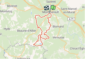
Trail Mountain bike Montmarault - ronde des bouchures Montmarault 30 km - Photo

ronde des bouchures Montmarault 30 km

© OpenStreetMap contributors
Length
Length
30 km
Max alt
Max alt
475 m
Uphill gradient
Uphill gradient
440 m
Km-Effort
Km-Effort  
36 km
Min alt
Min alt
392 m
Downhill gradient
Downhill gradient
443 m
Boucle
Boucle
Yes
Creation date :
2023-10-29 08:21:04.875
Updated on :
2023-10-29 11:27:24.092

(1 Reviews)

Mountain bike
Mountain bike
3h05
Difficulty : Difficult

Scan this QR Code to open this trail in the SityTrail application

FREE GPS app for hiking

Logo SityTrail SityTrail

IGN / Geographical institutes

Download SityTrail from the App Store Download SityTrail from Google Play

Logo SityTrail SityTrail World

The world is yours!

Download SityTrail from the App Store Download SityTrail from Google Play Download SityTrail on Huawei AppGallery

About

Trail Mountain bike of 30 km to be discovered at Auvergne-Rhône-Alpes, Allier, Montmarault. This trail is proposed by CamilleDusart.

Description

forêt de Château Charles

Elevation profile

Positioning

Country:
France
Region :
Auvergne-Rhône-Alpes
Department/Province :
Allier
Municipality :
Montmarault
Location:
Unknown
Start:(UTM)
496361 ; 5129211 (31T) N.

Comments

Please log in to post a review or rate the element


sportif. entre boue et arbres couchés. magnifique.


Trails nearby

Trail Walking Saint-Marcel-en-Murat - Frankrijk - Wandeling St.Marcel-en-Murat - Photo
Walking
gpstracks

Walking

Very easy
(1)
Saint-Marcel-en-Murat, Auvergne-Rhône-Alpes, Allier, France
13.2 km | 15.6 km-effort
Unknown
Yes
Trail Walking Sazeret - Frankrijk - Wandeling Sazeret - Photo
Walking
gpstracks

Walking

Very easy
Sazeret, Auvergne-Rhône-Alpes, Allier, France
11.7 km | 13.6 km-effort
Unknown
Yes
Trail Walking Saint-Marcel-en-Murat - Rando St Marcel - Photo
Walking
Guy Laurent

Walking

Difficult
Saint-Marcel-en-Murat, Auvergne-Rhône-Alpes, Allier, France
12.9 km | 15.3 km-effort
3h 55min
Yes
Trail Walking Blomard - montmarault - Photo
Walking
charrier

Walking

Very easy
Blomard, Auvergne-Rhône-Alpes, Allier, France
12.6 km | 15.3 km-effort
2h 58min
Yes


Close
My subscriptions