![](/images/other/stat-length.png)
![Trail Walking Martigues - 2023-10-24_19h28m45_Cirkwi-Rando_en_train_-_Traversée_de_la_Côte_Bleue - Photo](https://media.geolcdn.com/t/1900/400/ext.pjpeg?maxdim=2&url=https%3A%2F%2Fstatic1.geolcdn.com%2Fsiteimages%2Fupload%2Ffiles%2F1553511878bg_sport_marche.png)
2023-10-24_19h28m45_Cirkwi-Rando_en_train_-_Traversée_de_la_Côte_Bleue
Maryma
User
![Length](/images/other/stat-length.png)
![Max alt](https://static1.geolcdn.com/siteimages/upload/files/1508320355ic_sort_altitude_max_24dp.png)
![Uphill gradient](https://static1.geolcdn.com/siteimages/upload/files/1508320355ic_sort_den_pos_24dp.png)
![Km-Effort](/images/other/stat-length.png)
![Min alt](https://static1.geolcdn.com/siteimages/upload/files/1508320355ic_sort_altitude_min_24dp.png)
![Downhill gradient](https://static1.geolcdn.com/siteimages/upload/files/1508320355ic_sort_den_neg_24dp.png)
![Boucle](https://static1.geolcdn.com/siteimages/upload/files/16400158638029165_repeat_loop_refresh_sync_direction_icon.png)
![Walking](https://static1.geolcdn.com/sitytour/trail-icons/101.png)
15h15
Difficulty : Very difficult
![Scan this QR Code to open this trail in the SityTrail application](https://capi.geolives.com/qq0zvz2zws4bq2lad0pu/sitytour/trails/3849629/qr.png?size=200)
FREE GPS app for hiking
About
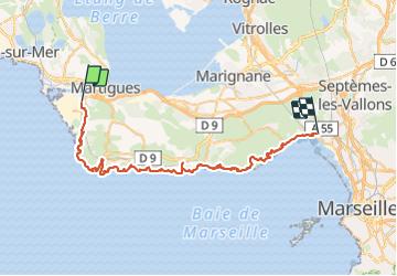
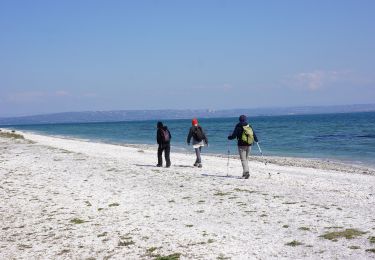
Trail Walking of 53 km to be discovered at Provence-Alpes-Côte d'Azur, Bouches-du-Rhône, Martigues. This trail is proposed by Maryma.
Description
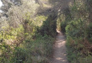
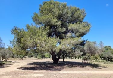
Une traversée idyllique de la Côte Bleue entre plages, criques, calanques et villages de pêcheurs avec des vues imprenables sur la rade de Marseille. Itinéraire nécessitant plusieurs jours de marche mais très accessible grâce à la ligne TER Marseille-Miramas par la Côte Bleue
Positioning
Comments
Trails nearby
![Trail On foot Port-de-Bouc - La Presqu’ile - Le sentier du littoral - Photo](https://media.geolcdn.com/t/375/260/7fd51f05-a6e7-42de-ab91-8a11cdb4314b.jpeg&format=jpg&maxdim=2)
![On foot On foot](https://static1.geolcdn.com/sitytour/trail-icons/100.png)
On foot
![](/images/other/stat-length.png)
![](https://static1.geolcdn.com/siteimages/upload/files/16400158638029165_repeat_loop_refresh_sync_direction_icon.png)
![Trail On foot Port-de-Bouc - Forêt de Castillon Etangs de Pourra et d’Engrenier - Photo](https://media.geolcdn.com/t/375/260/b4485374-af03-4dfc-85d7-4833d4297133.jpeg&format=jpg&maxdim=2)
![On foot On foot](https://static1.geolcdn.com/sitytour/trail-icons/100.png)
On foot
![](/images/other/stat-length.png)
![](https://static1.geolcdn.com/siteimages/upload/files/16400158638029165_repeat_loop_refresh_sync_direction_icon.png)
![Trail Walking Martigues - Parc de Figuerolles 26.5.24 - Photo](https://media.geolcdn.com/t/375/260/cfe36c57-0ab2-4f94-9dae-8a49ceb2c9ba.jpg&format=jpg&maxdim=2)
![Walking Walking](https://static1.geolcdn.com/sitytour/trail-icons/101.png)
Walking
![](/images/other/stat-length.png)
![](https://static1.geolcdn.com/siteimages/upload/files/16400158638029165_repeat_loop_refresh_sync_direction_icon.png)
![Trail Walking Martigues - Figuerrolles - Photo](https://media.geolcdn.com/t/375/260/4a5f1588-9bfa-4aa2-87f0-3f537570d4aa.jpg&format=jpg&maxdim=2)
![Walking Walking](https://static1.geolcdn.com/sitytour/trail-icons/101.png)
Walking
![](/images/other/stat-length.png)
![](https://static1.geolcdn.com/siteimages/upload/files/16400158638029165_repeat_loop_refresh_sync_direction_icon.png)
![Trail Walking Martigues - Promenade sur la rive de l'étang de Berre - Photo](https://media.geolcdn.com/t/375/260/7e13284d-163b-4a11-a7aa-ccfaecaf0dbc.jpg&format=jpg&maxdim=2)
![Walking Walking](https://static1.geolcdn.com/sitytour/trail-icons/101.png)
Walking
![](/images/other/stat-length.png)
![](https://static1.geolcdn.com/siteimages/upload/files/16400158638029165_repeat_loop_refresh_sync_direction_icon.png)
![Trail Walking Martigues - le parc de Figuerolles - Photo](https://media.geolcdn.com/t/375/260/5cd4b284-43d0-4749-a83d-d42e7a468467.jpg&format=jpg&maxdim=2)
![Walking Walking](https://static1.geolcdn.com/sitytour/trail-icons/101.png)
Walking
![](/images/other/stat-length.png)
![](https://static1.geolcdn.com/siteimages/upload/files/16400158638029165_repeat_loop_refresh_sync_direction_icon.png)
![Trail On foot Martigues - Boucle de Figuerolles - Photo](https://media.geolcdn.com/t/375/260/95277df0-03ce-438e-8003-6258ba4d95b2.jpeg&format=jpg&maxdim=2)
![On foot On foot](https://static1.geolcdn.com/sitytour/trail-icons/100.png)
On foot
![](/images/other/stat-length.png)
![](https://static1.geolcdn.com/siteimages/upload/files/16400158638029165_repeat_loop_refresh_sync_direction_icon.png)
![Trail On foot Martigues - Vestiges Militaires - Photo](https://media.geolcdn.com/t/375/260/6e507b0b-ffdb-4c7c-b8fe-ce4599d1b5df.jpeg&format=jpg&maxdim=2)
![On foot On foot](https://static1.geolcdn.com/sitytour/trail-icons/100.png)
On foot
![](/images/other/stat-length.png)
![](https://static1.geolcdn.com/siteimages/upload/files/16400158638029165_repeat_loop_refresh_sync_direction_icon.png)
![Walking Walking](https://static1.geolcdn.com/sitytour/trail-icons/101.png)
Walking
![](/images/other/stat-length.png)
![](https://static1.geolcdn.com/siteimages/upload/files/16400158638029165_repeat_loop_refresh_sync_direction_icon.png)