![](/images/other/stat-length.png)
![Trail Walking Hergiswil (NW) - YHH065 Frakmüntegg - Alpnachstadt - Photo](https://media.geolcdn.com/t/1900/400/ext.pjpeg?maxdim=2&url=https%3A%2F%2Fstatic1.geolcdn.com%2Fsiteimages%2Fupload%2Ffiles%2F1553511878bg_sport_marche.png)
YHH065 Frakmüntegg - Alpnachstadt
yveshumbert
User
![Length](/images/other/stat-length.png)
Length
7.9 km
![Max alt](https://static1.geolcdn.com/siteimages/upload/files/1508320355ic_sort_altitude_max_24dp.png)
Max alt
1407 m
![Uphill gradient](https://static1.geolcdn.com/siteimages/upload/files/1508320355ic_sort_den_pos_24dp.png)
Uphill gradient
189 m
![Km-Effort](/images/other/stat-length.png)
Km-Effort
13.6 km
![Min alt](https://static1.geolcdn.com/siteimages/upload/files/1508320355ic_sort_altitude_min_24dp.png)
Min alt
441 m
![Downhill gradient](https://static1.geolcdn.com/siteimages/upload/files/1508320355ic_sort_den_neg_24dp.png)
Downhill gradient
1143 m
![Boucle](https://static1.geolcdn.com/siteimages/upload/files/16400158638029165_repeat_loop_refresh_sync_direction_icon.png)
Boucle
No
Creation date :
2015-06-02 00:00:00.0
Updated on :
2015-06-02 00:00:00.0
![Walking](https://static1.geolcdn.com/sitytour/trail-icons/101.png)
3h00
Difficulty : Unknown
![Scan this QR Code to open this trail in the SityTrail application](https://capi.geolives.com/qq0zvz2zws4bq2lad0pu/sitytour/trails/38482/qr.png?size=200)
FREE GPS app for hiking
About
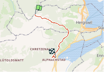
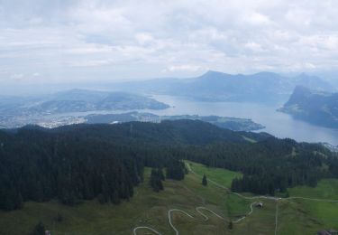
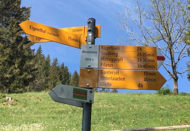
Trail Walking of 7.9 km to be discovered at Nidwalden, Unknown, Hergiswil (NW). This trail is proposed by yveshumbert.
Description
De Lucerne on prend le bus jusqu'à Kriens. De là on prend le télécabine jusqu'à Frakmüntegg. L'itinéraire facile se fait pratiquement tout en descente. A Alpnachstadt, on peut prendre le train pour rentrer à Lucerne
Positioning
Country:
Switzerland
Region :
Nidwalden
Department/Province :
Unknown
Municipality :
Hergiswil (NW)
Location:
Unknown
Start:(Dec)
Start:(UTM)
443125 ; 5204399 (32T) N.
Comments
Trails nearby
![Trail On foot Kriens - Kriens Pilatus-Bahnen - Fräkmüntegg - Photo](https://media.geolcdn.com/t/375/260/8f1cc11a-2dbf-4c82-8ffc-5a9ff26d8a5a.jpeg&format=jpg&maxdim=2)
![On foot On foot](https://static1.geolcdn.com/sitytour/trail-icons/100.png)
Kriens Pilatus-Bahnen - Fräkmüntegg
On foot
Easy
Kriens,
Luzern,
Unknown,
Switzerland
![](/images/other/stat-length.png)
6.4 km | 15.8 km-effort
3h 35min
![](https://static1.geolcdn.com/siteimages/upload/files/16400158638029165_repeat_loop_refresh_sync_direction_icon.png)
No
![Trail On foot Schwarzenberg - Sonnhalde - Linden - Meiestoss - Moos - Photo](https://media.geolcdn.com/t/375/260/d99a6560-13fd-4b2b-980d-bb60ecbf2480.jpeg&format=jpg&maxdim=2)
![On foot On foot](https://static1.geolcdn.com/sitytour/trail-icons/100.png)
Sonnhalde - Linden - Meiestoss - Moos
On foot
Easy
Schwarzenberg,
Luzern,
Unknown,
Switzerland
![](/images/other/stat-length.png)
3.7 km | 4.4 km-effort
59min
![](https://static1.geolcdn.com/siteimages/upload/files/16400158638029165_repeat_loop_refresh_sync_direction_icon.png)
No
![Trail On foot Kriens - Holderchäppeli - Ränggloch - Photo](https://media.geolcdn.com/t/375/260/9f79bb69-e409-4f6d-8046-1e25cb4469a1.jpeg&format=jpg&maxdim=2)
![On foot On foot](https://static1.geolcdn.com/sitytour/trail-icons/100.png)
Holderchäppeli - Ränggloch
On foot
Easy
Kriens,
Luzern,
Unknown,
Switzerland
![](/images/other/stat-length.png)
3.9 km | 5.4 km-effort
1h 13min
![](https://static1.geolcdn.com/siteimages/upload/files/16400158638029165_repeat_loop_refresh_sync_direction_icon.png)
No
![Trail On foot Schwarzenberg - Chraigütsch - Ober Lauelen - Photo](https://media.geolcdn.com/t/375/260/85fba48d-24a2-4e1b-bbfb-e017727bb6f4.jpeg&format=jpg&maxdim=2)
![On foot On foot](https://static1.geolcdn.com/sitytour/trail-icons/100.png)
Chraigütsch - Ober Lauelen
On foot
Easy
Schwarzenberg,
Luzern,
Unknown,
Switzerland
![](/images/other/stat-length.png)
3.4 km | 6.8 km-effort
1h 32min
![](https://static1.geolcdn.com/siteimages/upload/files/16400158638029165_repeat_loop_refresh_sync_direction_icon.png)
No
![Trail On foot Kriens - Rund um Kriens - Photo](https://media.geolcdn.com/t/375/260/465c718f-9f4a-4f65-9166-5ac49f504063.jpeg&format=jpg&maxdim=2)
![On foot On foot](https://static1.geolcdn.com/sitytour/trail-icons/100.png)
![Trail Walking Kriens - eigenthal - Photo](https://media.geolcdn.com/t/375/260/ext.jpg?maxdim=2&url=https%3A%2F%2Fservices.sitytrail.com%2FGeolivesWS%2FDownloadMedia.ashx%3FTrailID%3D163190%26Media%3D20121118113414.jpeg)
![Walking Walking](https://static1.geolcdn.com/sitytour/trail-icons/101.png)
![Trail On foot Schwarzenberg - Wassermoos - Lifelen - Photo](https://media.geolcdn.com/t/375/260/ext.jpg?maxdim=2&url=https%3A%2F%2Fstatic1.geolcdn.com%2Fsiteimages%2Fupload%2Ffiles%2F1545311037marcheuse_200dpi.jpg)
![On foot On foot](https://static1.geolcdn.com/sitytour/trail-icons/100.png)
Wassermoos - Lifelen
On foot
Easy
Schwarzenberg,
Luzern,
Unknown,
Switzerland
![](/images/other/stat-length.png)
3.7 km | 5.2 km-effort
1h 11min
![](https://static1.geolcdn.com/siteimages/upload/files/16400158638029165_repeat_loop_refresh_sync_direction_icon.png)
No
![Trail On foot Schwarzenberg - Lifelen - Moos - 850 - Meiestoss - Photo](https://media.geolcdn.com/t/375/260/ext.jpg?maxdim=2&url=https%3A%2F%2Fstatic1.geolcdn.com%2Fsiteimages%2Fupload%2Ffiles%2F1545311037marcheuse_200dpi.jpg)
![On foot On foot](https://static1.geolcdn.com/sitytour/trail-icons/100.png)
Lifelen - Moos - 850 - Meiestoss
On foot
Easy
Schwarzenberg,
Luzern,
Unknown,
Switzerland
![](/images/other/stat-length.png)
3.3 km | 5.5 km-effort
1h 14min
![](https://static1.geolcdn.com/siteimages/upload/files/16400158638029165_repeat_loop_refresh_sync_direction_icon.png)
No
![Trail On foot Schwarzenberg - Stafel - Trochenmattsattel - Stäfeli - Photo](https://media.geolcdn.com/t/375/260/ext.jpg?maxdim=2&url=https%3A%2F%2Fstatic1.geolcdn.com%2Fsiteimages%2Fupload%2Ffiles%2F1545311037marcheuse_200dpi.jpg)
![On foot On foot](https://static1.geolcdn.com/sitytour/trail-icons/100.png)
Stafel - Trochenmattsattel - Stäfeli
On foot
Easy
Schwarzenberg,
Luzern,
Unknown,
Switzerland
![](/images/other/stat-length.png)
3.2 km | 5.1 km-effort
1h 9min
![](https://static1.geolcdn.com/siteimages/upload/files/16400158638029165_repeat_loop_refresh_sync_direction_icon.png)
No