![](/images/other/stat-length.png)
![Trail Walking Kruisem - Wannegel-Lede en Mullem - Photo](https://media.geolcdn.com/t/1900/400/ext.pjpeg?maxdim=2&url=https%3A%2F%2Fservices.sitytrail.com%2FGeolivesWS%2FDownloadMedia.ashx%3FTrailID%3D384647%26Media%3D20150209115713.jpg)
Wannegel-Lede en Mullem
mavbelgium
User
![Length](/images/other/stat-length.png)
Length
15.4 km
![Max alt](https://static1.geolcdn.com/siteimages/upload/files/1508320355ic_sort_altitude_max_24dp.png)
Max alt
57 m
![Uphill gradient](https://static1.geolcdn.com/siteimages/upload/files/1508320355ic_sort_den_pos_24dp.png)
Uphill gradient
125 m
![Km-Effort](/images/other/stat-length.png)
Km-Effort
17 km
![Min alt](https://static1.geolcdn.com/siteimages/upload/files/1508320355ic_sort_altitude_min_24dp.png)
Min alt
16 m
![Downhill gradient](https://static1.geolcdn.com/siteimages/upload/files/1508320355ic_sort_den_neg_24dp.png)
Downhill gradient
119 m
![Boucle](https://static1.geolcdn.com/siteimages/upload/files/16400158638029165_repeat_loop_refresh_sync_direction_icon.png)
Boucle
Yes
Creation date :
2015-02-09 00:00:00.0
Updated on :
2015-02-09 00:00:00.0
![Walking](https://static1.geolcdn.com/sitytour/trail-icons/101.png)
3h26
Difficulty : Medium
![Scan this QR Code to open this trail in the SityTrail application](https://capi.geolives.com/qq0zvz2zws4bq2lad0pu/sitytour/trails/384647/qr.png?size=200)
FREE GPS app for hiking
About
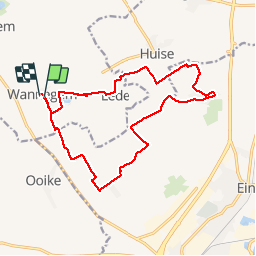
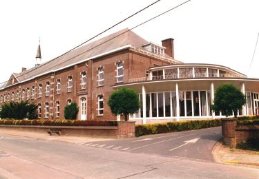
Trail Walking of 15.4 km to be discovered at Flanders, East Flanders, Kruisem. This trail is proposed by mavbelgium.
Description
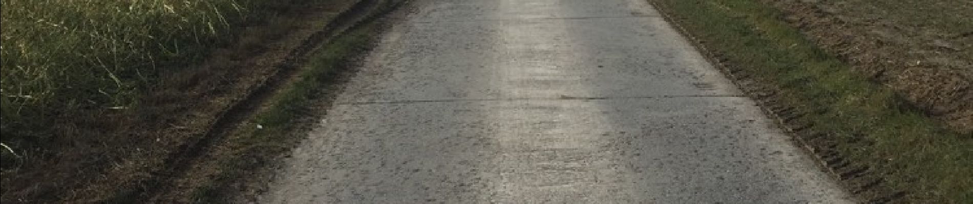
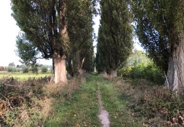
Wannegem-Lede naar Mullem en terug.. enkele stukken pad en verder landelijke wegen.. mooie route.. daarna lekker eten in de 'Hermelijn'
Positioning
Country:
Belgium
Region :
Flanders
Department/Province :
East Flanders
Municipality :
Kruisem
Location:
Wannegem-Lede
Start:(Dec)
Start:(UTM)
538815 ; 5637672 (31U) N.
Comments
Trails nearby
![Trail On foot Kruisem - Kordaalroute - Photo](https://media.geolcdn.com/t/375/260/857aec67-4600-4807-a54c-d1b379eef518.jpeg&format=jpg&maxdim=2)
![On foot On foot](https://static1.geolcdn.com/sitytour/trail-icons/100.png)
Kordaalroute
On foot
Easy
Kruisem,
Flanders,
East Flanders,
Belgium
![](/images/other/stat-length.png)
6.3 km | 7.2 km-effort
1h 38min
![](https://static1.geolcdn.com/siteimages/upload/files/16400158638029165_repeat_loop_refresh_sync_direction_icon.png)
Yes
![Trail Electric bike Oudenaarde - audenarde parc Lieds - Photo](https://media.geolcdn.com/t/375/260/aff480f0-3c26-4265-87ac-95242c49e7f9.jpg&format=jpg&maxdim=2)
![Electric bike Electric bike](https://static1.geolcdn.com/sitytour/trail-icons/205.png)
audenarde parc Lieds
Electric bike
Very easy
Oudenaarde,
Flanders,
East Flanders,
Belgium
![](/images/other/stat-length.png)
5.6 km | 6 km-effort
48min
![](https://static1.geolcdn.com/siteimages/upload/files/16400158638029165_repeat_loop_refresh_sync_direction_icon.png)
Yes
![Trail On foot Oudenaarde - Rooigemsebeek wandelroute - Photo](https://media.geolcdn.com/t/375/260/62584602-0b01-4943-af2b-746bf43c93c8.jpeg&format=jpg&maxdim=2)
![On foot On foot](https://static1.geolcdn.com/sitytour/trail-icons/100.png)
Rooigemsebeek wandelroute
On foot
Easy
Oudenaarde,
Flanders,
East Flanders,
Belgium
![](/images/other/stat-length.png)
13.5 km | 15 km-effort
3h 24min
![](https://static1.geolcdn.com/siteimages/upload/files/16400158638029165_repeat_loop_refresh_sync_direction_icon.png)
Yes
![Trail Walking Kruisem - Kruishoutem 20 km - Photo](https://media.geolcdn.com/t/375/260/86e5f242-d7b6-4f30-8dd9-0932faf7c499.jpg&format=jpg&maxdim=2)
![Walking Walking](https://static1.geolcdn.com/sitytour/trail-icons/101.png)
Kruishoutem 20 km
Walking
Medium
Kruisem,
Flanders,
East Flanders,
Belgium
![](/images/other/stat-length.png)
20 km | 23 km-effort
5h 21min
![](https://static1.geolcdn.com/siteimages/upload/files/16400158638029165_repeat_loop_refresh_sync_direction_icon.png)
Yes
![Trail Walking Kruisem - Kruishoutem 20,5 km - Photo](https://media.geolcdn.com/t/375/260/ext.jpg?maxdim=2&url=https%3A%2F%2Fservices.sitytrail.com%2FGeolivesWS%2FDownloadMedia.ashx%3FTrailID%3D1052822%26Media%3D20181007150414.jpg)
![Walking Walking](https://static1.geolcdn.com/sitytour/trail-icons/101.png)
Kruishoutem 20,5 km
Walking
Easy
Kruisem,
Flanders,
East Flanders,
Belgium
![](/images/other/stat-length.png)
21 km | 23 km-effort
5h 25min
![](https://static1.geolcdn.com/siteimages/upload/files/16400158638029165_repeat_loop_refresh_sync_direction_icon.png)
Yes
![Trail Walking Kruisem - Nokere - Kordaalwandeling (6km) StepAway.be - Photo](https://media.geolcdn.com/t/375/260/ext.jpg?maxdim=2&url=https%3A%2F%2Fservices.sitytrail.com%2FGeolivesWS%2FDownloadMedia.ashx%3FTrailID%3D707954%26Media%3D5d33eb46-4277-4483-8934-e39451b123c2.JPG)
![Walking Walking](https://static1.geolcdn.com/sitytour/trail-icons/101.png)
Nokere - Kordaalwandeling (6km) StepAway.be
Walking
Easy
Kruisem,
Flanders,
East Flanders,
Belgium
![](/images/other/stat-length.png)
6.1 km | 7 km-effort
1h 33min
![](https://static1.geolcdn.com/siteimages/upload/files/16400158638029165_repeat_loop_refresh_sync_direction_icon.png)
Yes
![Trail Walking Oudenaarde - 72.674 Oudenaarde - Langs Berg & Kapel - Photo](https://media.geolcdn.com/t/375/260/27651946-0cae-4d5c-8984-24f0b1f9a1ea.jpg&format=jpg&maxdim=2)
![Walking Walking](https://static1.geolcdn.com/sitytour/trail-icons/101.png)
72.674 Oudenaarde - Langs Berg & Kapel
Walking
Medium
(1)
Oudenaarde,
Flanders,
East Flanders,
Belgium
![](/images/other/stat-length.png)
24 km | 27 km-effort
6h 41min
![](https://static1.geolcdn.com/siteimages/upload/files/16400158638029165_repeat_loop_refresh_sync_direction_icon.png)
Yes
![Trail Other activity Kruisem - Huise 8.5 km - Photo](https://media.geolcdn.com/t/375/260/ext.jpg?maxdim=2&url=https%3A%2F%2Fstatic1.geolcdn.com%2Fsiteimages%2Fupload%2Ffiles%2F1545311037marcheuse_200dpi.jpg)
![Other activity Other activity](https://static1.geolcdn.com/sitytour/trail-icons/900.png)
Huise 8.5 km
Other activity
Very easy
Kruisem,
Flanders,
East Flanders,
Belgium
![](/images/other/stat-length.png)
8.3 km | 9.3 km-effort
2h 0min
![](https://static1.geolcdn.com/siteimages/upload/files/16400158638029165_repeat_loop_refresh_sync_direction_icon.png)
Yes
![Trail Cycle Kruisem - Gulden Eiroute - Photo](https://media.geolcdn.com/t/375/260/ext.jpg?maxdim=2&url=https%3A%2F%2Fstatic1.geolcdn.com%2Fsiteimages%2Fupload%2Ffiles%2F1524743154velo.jpg)
![Cycle Cycle](https://static1.geolcdn.com/sitytour/trail-icons/200.png)
Gulden Eiroute
Cycle
Very easy
Kruisem,
Flanders,
East Flanders,
Belgium
![](/images/other/stat-length.png)
46 km | 51 km-effort
3h 0min
![](https://static1.geolcdn.com/siteimages/upload/files/16400158638029165_repeat_loop_refresh_sync_direction_icon.png)
Yes