![](/images/other/stat-length.png)
![Trail Walking Saint-Martin-Vésubie - Trecolpas - Photo](https://media.geolcdn.com/t/1900/400/a52ea12b-d5d9-4e15-9abc-9c3622ebd744.jpg&format=pjpeg&maxdim=2)
Trecolpas
bozo1970
User
![Length](/images/other/stat-length.png)
Length
9.7 km
![Max alt](https://static1.geolcdn.com/siteimages/upload/files/1508320355ic_sort_altitude_max_24dp.png)
Max alt
2163 m
![Uphill gradient](https://static1.geolcdn.com/siteimages/upload/files/1508320355ic_sort_den_pos_24dp.png)
Uphill gradient
518 m
![Km-Effort](/images/other/stat-length.png)
Km-Effort
16.6 km
![Min alt](https://static1.geolcdn.com/siteimages/upload/files/1508320355ic_sort_altitude_min_24dp.png)
Min alt
1682 m
![Downhill gradient](https://static1.geolcdn.com/siteimages/upload/files/1508320355ic_sort_den_neg_24dp.png)
Downhill gradient
517 m
![Boucle](https://static1.geolcdn.com/siteimages/upload/files/16400158638029165_repeat_loop_refresh_sync_direction_icon.png)
Boucle
Yes
Creation date :
2023-10-19 07:13:02.0
Updated on :
2023-10-20 08:15:40.817
![Walking](https://static1.geolcdn.com/sitytour/trail-icons/101.png)
2h44
Difficulty : Easy
![Scan this QR Code to open this trail in the SityTrail application](https://capi.geolives.com/qq0zvz2zws4bq2lad0pu/sitytour/trails/3844292/qr.png?size=200)
FREE GPS app for hiking
About
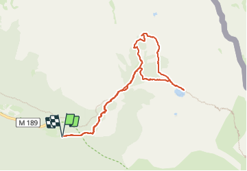
Trail Walking of 9.7 km to be discovered at Provence-Alpes-Côte d'Azur, Maritime Alps, Saint-Martin-Vésubie. This trail is proposed by bozo1970.
Description
Montée depuis le dernier parking du Boréon
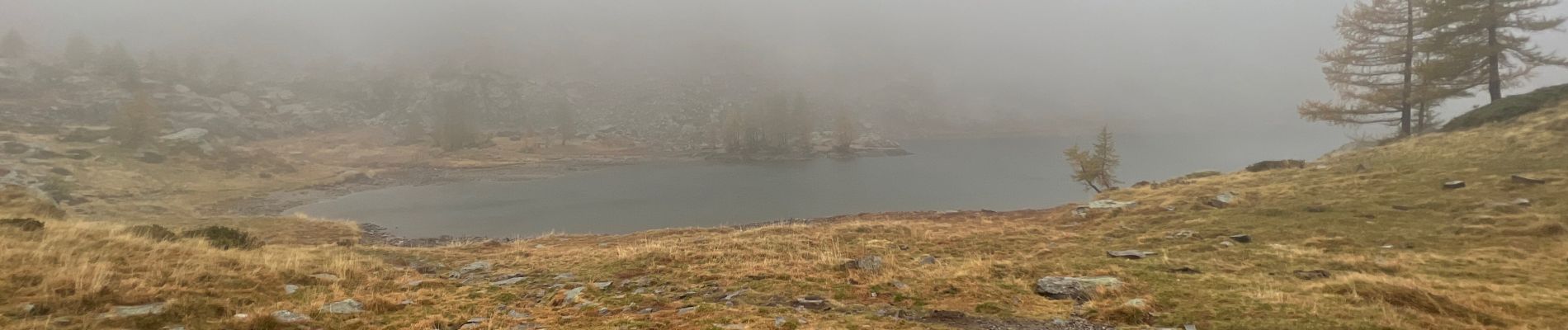
Lac de Trécolpas en 1h10' 3km800 et D 482m
Retour par le refuge de Cougourde en 1h45' 5km700 et D 697
Boucle en 2h43' 9km600 et D 716m
Jolie petite boucle pour un jour de pluie
Positioning
Country:
France
Region :
Provence-Alpes-Côte d'Azur
Department/Province :
Maritime Alps
Municipality :
Saint-Martin-Vésubie
Location:
Unknown
Start:(Dec)
Start:(UTM)
364843 ; 4885254 (32T) N.
Comments
Trails nearby
![Trail Walking Saint-Martin-Vésubie - Lac de Trécolpas - Photo](https://media.geolcdn.com/t/375/260/ext.jpg?maxdim=2&url=https%3A%2F%2Fservices.sitytrail.com%2FGeolivesWS%2FDownloadMedia.ashx%3FTrailID%3D311062%26Media%3Dfix__20140607150849.jpg)
![Walking Walking](https://static1.geolcdn.com/sitytour/trail-icons/101.png)
Lac de Trécolpas
Walking
Medium
(2)
Saint-Martin-Vésubie,
Provence-Alpes-Côte d'Azur,
Maritime Alps,
France
![](/images/other/stat-length.png)
13.3 km | 20 km-effort
4h 17min
![](https://static1.geolcdn.com/siteimages/upload/files/16400158638029165_repeat_loop_refresh_sync_direction_icon.png)
Yes
![Trail On foot Saint-Martin-Vésubie - SityTrail - Lacs de Prals - Photo](https://media.geolcdn.com/t/375/260/ext.jpg?maxdim=2&url=https%3A%2F%2Fstatic1.geolcdn.com%2Fsiteimages%2Fupload%2Ffiles%2F1545311037marcheuse_200dpi.jpg)
![On foot On foot](https://static1.geolcdn.com/sitytour/trail-icons/100.png)
SityTrail - Lacs de Prals
On foot
Easy
(1)
Saint-Martin-Vésubie,
Provence-Alpes-Côte d'Azur,
Maritime Alps,
France
![](/images/other/stat-length.png)
6.7 km | 13.6 km-effort
3h 5min
![](https://static1.geolcdn.com/siteimages/upload/files/16400158638029165_repeat_loop_refresh_sync_direction_icon.png)
Yes
![Trail Walking Saint-Martin-Vésubie - lacs bessons - Photo](https://media.geolcdn.com/t/375/260/a0e4b44d-1510-4e32-82be-e7e2ee548788.jpg&format=jpg&maxdim=2)
![Walking Walking](https://static1.geolcdn.com/sitytour/trail-icons/101.png)
lacs bessons
Walking
Very easy
(1)
Saint-Martin-Vésubie,
Provence-Alpes-Côte d'Azur,
Maritime Alps,
France
![](/images/other/stat-length.png)
13.1 km | 0 m-effort
7h 36min
![](https://static1.geolcdn.com/siteimages/upload/files/16400158638029165_repeat_loop_refresh_sync_direction_icon.png)
Yes
![Trail Walking Saint-Martin-Vésubie - Lac Ne`gre bis - Photo](https://media.geolcdn.com/t/375/260/ext.jpg?maxdim=2&url=https%3A%2F%2Fservices.sitytrail.com%2FGeolivesWS%2FDownloadMedia.ashx%3FTrailID%3D733947%26Media%3D20170416133857.jpg)
![Walking Walking](https://static1.geolcdn.com/sitytour/trail-icons/101.png)
Lac Ne`gre bis
Walking
Medium
(1)
Saint-Martin-Vésubie,
Provence-Alpes-Côte d'Azur,
Maritime Alps,
France
![](/images/other/stat-length.png)
13.1 km | 23 km-effort
3h 42min
![](https://static1.geolcdn.com/siteimages/upload/files/16400158638029165_repeat_loop_refresh_sync_direction_icon.png)
Yes
![Trail Walking Saint-Martin-Vésubie - Boucle Les lacs de Prals par la cime de la Vallette - Photo](https://media.geolcdn.com/t/375/260/2c298eac-1e8e-4f8d-83e4-c08337da9759.jpg&format=jpg&maxdim=2)
![Walking Walking](https://static1.geolcdn.com/sitytour/trail-icons/101.png)
Boucle Les lacs de Prals par la cime de la Vallette
Walking
Very difficult
Saint-Martin-Vésubie,
Provence-Alpes-Côte d'Azur,
Maritime Alps,
France
![](/images/other/stat-length.png)
13.2 km | 24 km-effort
4h 50min
![](https://static1.geolcdn.com/siteimages/upload/files/16400158638029165_repeat_loop_refresh_sync_direction_icon.png)
Yes
![Trail Walking Saint-Martin-Vésubie - Lac Trecolpas - Pas des Ladres - Col de Fenestre - Refuge Cougourde - Photo](https://media.geolcdn.com/t/375/260/541e5768-e182-4791-be6f-0df4a21d2a23.jpg&format=jpg&maxdim=2)
![Walking Walking](https://static1.geolcdn.com/sitytour/trail-icons/101.png)
Lac Trecolpas - Pas des Ladres - Col de Fenestre - Refuge Cougourde
Walking
Very difficult
Saint-Martin-Vésubie,
Provence-Alpes-Côte d'Azur,
Maritime Alps,
France
![](/images/other/stat-length.png)
15.5 km | 29 km-effort
6h 39min
![](https://static1.geolcdn.com/siteimages/upload/files/16400158638029165_repeat_loop_refresh_sync_direction_icon.png)
Yes
![Trail On foot Saint-Martin-Vésubie - Col de Cerise - Photo](https://media.geolcdn.com/t/375/260/90b1ce11-d155-4ca1-8f15-a1d1ec21efc7.jpeg&format=jpg&maxdim=2)
![On foot On foot](https://static1.geolcdn.com/sitytour/trail-icons/100.png)
Col de Cerise
On foot
Medium
Saint-Martin-Vésubie,
Provence-Alpes-Côte d'Azur,
Maritime Alps,
France
![](/images/other/stat-length.png)
9.7 km | 23 km-effort
5h 18min
![](https://static1.geolcdn.com/siteimages/upload/files/16400158638029165_repeat_loop_refresh_sync_direction_icon.png)
Yes
![Trail On foot Saint-Martin-Vésubie - Circuit de Fenestre - Photo](https://media.geolcdn.com/t/375/260/2f55aaab-545e-409a-9c6e-8c2e9c42d8aa.jpeg&format=jpg&maxdim=2)
![On foot On foot](https://static1.geolcdn.com/sitytour/trail-icons/100.png)
Circuit de Fenestre
On foot
Easy
Saint-Martin-Vésubie,
Provence-Alpes-Côte d'Azur,
Maritime Alps,
France
![](/images/other/stat-length.png)
8.1 km | 16.4 km-effort
3h 44min
![](https://static1.geolcdn.com/siteimages/upload/files/16400158638029165_repeat_loop_refresh_sync_direction_icon.png)
Yes
![Trail On foot Saint-Martin-Vésubie - Circuit de Trécolpas - Photo](https://media.geolcdn.com/t/375/260/f92e70c7-1f9c-4fa6-ae6b-2c614b3b921c.jpeg&format=jpg&maxdim=2)
![On foot On foot](https://static1.geolcdn.com/sitytour/trail-icons/100.png)
Circuit de Trécolpas
On foot
Easy
Saint-Martin-Vésubie,
Provence-Alpes-Côte d'Azur,
Maritime Alps,
France
![](/images/other/stat-length.png)
8.9 km | 15.8 km-effort
3h 35min
![](https://static1.geolcdn.com/siteimages/upload/files/16400158638029165_repeat_loop_refresh_sync_direction_icon.png)
Yes