


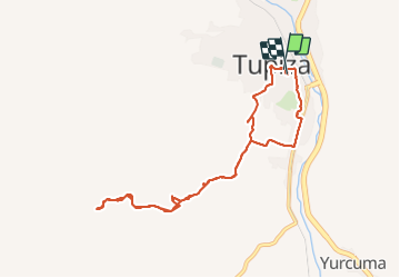
Tupiza

Geert H.
User

Length
12.6 km

Max alt
3119 m

Uphill gradient
250 m
Km-Effort
15.9 km

Min alt
2940 m

Downhill gradient
253 m
Boucle
Yes
Creation date :
2023-10-16 12:04:14.376
Updated on :
2023-12-31 09:01:22.31
3h36
Difficulty : Difficult

FREE GPS app for hiking
 SityTrail
IGN / Geographical institutes
SityTrail World
The world is yours!
About
Trail Walking of 12.6 km to be discovered at Potosí, Sur Chichas, Tupiza. This trail is proposed by Geert H..
Positioning
Country:
Bolivia, Plurinational State of
Region :
Potosí
Department/Province :
Sur Chichas
Municipality :
Tupiza
Location:
Unknown
Start:(Dec)
Start:(UTM)
218170 ; 7626207 (20K) S.
Comments
Trails nearby