Trail Walking Beauraing - marche Fromelennes , Dion, bois de la douane , retour Fromelennes, Dion , bel air , Fromelennes  - Photo

marche Fromelennes , Dion, bois de la douane , retour Fromelennes, Dion , bel air , Fromelennes

© OpenStreetMap contributors
Length
Length
10.8 km
Max alt
Max alt
194 m
Uphill gradient
Uphill gradient
231 m
Km-Effort
Km-Effort  
13.9 km
Min alt
Min alt
113 m
Downhill gradient
Downhill gradient
240 m
Boucle
Boucle
No
Creation date :
2015-02-05 00:00:00.0
Updated on :
2015-02-05 00:00:00.0

(2 Reviews)

Walking
Walking
2h57
Difficulty : Easy

Scan this QR Code to open this trail in the SityTrail application

FREE GPS app for hiking

Logo SityTrail SityTrail

IGN / Geographical institutes

Download SityTrail from the App Store Download SityTrail from Google Play

Logo SityTrail SityTrail World

The world is yours!

Download SityTrail from the App Store Download SityTrail from Google Play Download SityTrail on Huawei AppGallery

About

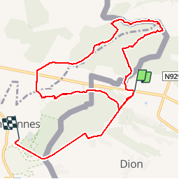
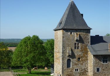
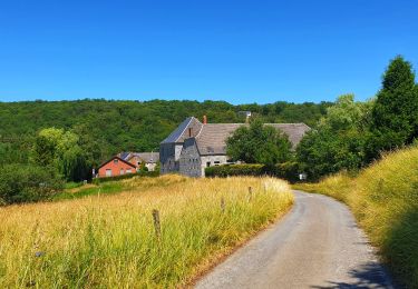
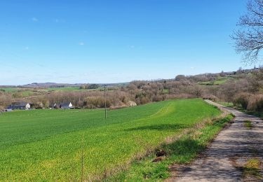
Trail Walking of 10.8 km to be discovered at Wallonia, Namur, Beauraing. This trail is proposed by pascal0859.

Elevation profile

Positioning

Country:
Belgium
Region :
Wallonia
Department/Province :
Namur
Municipality :
Beauraing
Location:
Dion
Start:(UTM)
635014 ; 5554699 (31U) N.

Comments

Please log in to post a review or rate the element


Randonnée à éviter, sauf pour les aventuriers... 1. Je pense que la personne qui a publié cette rando a enregistré son trajet de retour en voiture. voir le tracé en dehors de la boucle. On marche sur la route... 2. Il faut traverser une prairie privée. L'entrée est facile mais pas la sortie... 3. Pas sûr que les chemins dans les bois soient publics. il s'agit plus que probablement de traits de chasse... 4. Les chemins dans les bois se terminent brutalement. Ce qui fait que le trajet se transforme en parcours de traqueurs... Désolé pour la critique mais je pense qu'il fallait préciser...


Trails nearby

Trail Walking Beauraing - Winenne - Nature: trip to the countryside - Photo
Walking
PRO

Walking

Difficult
(7)
Beauraing, Wallonia, Namur, Belgium
20 km | 26 km-effort
6h 0min
Yes
Trail Walking Beauraing - RB-Na-28-En Famenne occidentale - Photo
Walking
PRO

Walking

Very difficult
(5)
Beauraing, Wallonia, Namur, Belgium
19.4 km | 24 km-effort
5h 33min
Yes
Trail Walking Beauraing - Javingue-Sevry - Roadbook discovering villages & landscapes - Photo
Walking
PRO

Walking

Easy
(6)
Beauraing, Wallonia, Namur, Belgium
7.7 km | 10.2 km-effort
2h 0min
Yes
Trail Walking Givet - Balade à Givet - Photo
Walking
tracegps

Walking

Medium
(3)
Givet, Grand Est, Ardennes, France
8 km | 9.4 km-effort
2h 0min
Yes
Trail Walking Givet - Promenade sur les remparts du Mont d'Haurs - Photo
Walking
tracegps

Walking

Medium
(3)
Givet, Grand Est, Ardennes, France
5.1 km | 6.7 km-effort
2h 0min
Yes
Trail Walking Hastière - Hastiere, Entre mont et vallée - Photo
Walking
pito0206

Walking

Medium
(2)
Hastière, Wallonia, Namur, Belgium
11.2 km | 14.3 km-effort
2h 5min
Yes
Trail Mountain bike Beauraing - Winenne - Nature: trip to the countryside - Photo
Mountain bike
PRO

Mountain bike

Medium
(3)
Beauraing, Wallonia, Namur, Belgium
20 km | 26 km-effort
1h 41min
Yes
Trail Walking Beauraing - Balade de Dion à Winenne - Beauraing - Photo
Walking
GUIDE
Desrumaux

Walking

Medium
(1)
Beauraing, Wallonia, Namur, Belgium
6.5 km | 8.5 km-effort
1h 55min
Yes
Trail Walking Beauraing - Balade à Winenne - Beauraing - Photo
Walking
GUIDE
Desrumaux

Walking

Difficult
Beauraing, Wallonia, Namur, Belgium
11.7 km | 14.7 km-effort
3h 20min
Yes


Close
My subscriptions