![](/images/other/stat-length.png)
![Trail Walking Ventron - Vers la Chaume du Grand Ventron - Photo](https://media.geolcdn.com/t/1900/400/ext.pjpeg?maxdim=2&url=https%3A%2F%2Fservices.sitytrail.com%2FGeolivesWS%2FDownloadMedia.ashx%3FTrailID%3D383028%26Media%3Dfix__20150203170354.jpg)
Vers la Chaume du Grand Ventron
jeanclaude12
User
![Length](/images/other/stat-length.png)
Length
6.4 km
![Max alt](https://static1.geolcdn.com/siteimages/upload/files/1508320355ic_sort_altitude_max_24dp.png)
Max alt
1203 m
![Uphill gradient](https://static1.geolcdn.com/siteimages/upload/files/1508320355ic_sort_den_pos_24dp.png)
Uphill gradient
332 m
![Km-Effort](/images/other/stat-length.png)
Km-Effort
10.9 km
![Min alt](https://static1.geolcdn.com/siteimages/upload/files/1508320355ic_sort_altitude_min_24dp.png)
Min alt
860 m
![Downhill gradient](https://static1.geolcdn.com/siteimages/upload/files/1508320355ic_sort_den_neg_24dp.png)
Downhill gradient
341 m
![Boucle](https://static1.geolcdn.com/siteimages/upload/files/16400158638029165_repeat_loop_refresh_sync_direction_icon.png)
Boucle
Yes
Creation date :
2015-02-03 00:00:00.0
Updated on :
2015-02-03 00:00:00.0
![Walking](https://static1.geolcdn.com/sitytour/trail-icons/101.png)
2h50
Difficulty : Medium
![Scan this QR Code to open this trail in the SityTrail application](https://capi.geolives.com/qq0zvz2zws4bq2lad0pu/sitytour/trails/383028/qr.png?size=200)
FREE GPS app for hiking
About
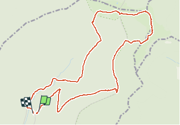
Trail Walking of 6.4 km to be discovered at Grand Est, Vosges, Ventron. This trail is proposed by jeanclaude12.
Description
Très belle randonnée en raquettes sous le soleil et sur un lit de neige de plus d'un mètre d'épaisseur, au départ du Parking des Places vers la Chaume du Grand Ventron par l'Envers du Gros Pré et retour sous le Droit du Gros Pré par le Chemin du Fond et la Fontaine ferrugineuse.
Positioning
Country:
France
Region :
Grand Est
Department/Province :
Vosges
Municipality :
Ventron
Location:
Unknown
Start:(Dec)
Start:(UTM)
343712 ; 5312642 (32T) N.
Comments
Trails nearby
![Trail Walking Wildenstein - 2022-02-20 Marche Kruth Grand Ventron - Photo](https://media.geolcdn.com/t/375/260/74324e84-ba09-479c-87ba-50417488039d.jpg&format=jpg&maxdim=2)
![Walking Walking](https://static1.geolcdn.com/sitytour/trail-icons/101.png)
2022-02-20 Marche Kruth Grand Ventron
Walking
Very difficult
(1)
Wildenstein,
Grand Est,
Haut-Rhin,
France
![](/images/other/stat-length.png)
16.8 km | 27 km-effort
4h 52min
![](https://static1.geolcdn.com/siteimages/upload/files/16400158638029165_repeat_loop_refresh_sync_direction_icon.png)
Yes
![Trail Walking Kruth - Autour du lac de Kruth-Wildenstein - Photo](https://media.geolcdn.com/t/375/260/c1e79833-f011-4190-a625-acd1b44dc0b0.jpeg&format=jpg&maxdim=2)
![Walking Walking](https://static1.geolcdn.com/sitytour/trail-icons/101.png)
Autour du lac de Kruth-Wildenstein
Walking
Medium
(1)
Kruth,
Grand Est,
Haut-Rhin,
France
![](/images/other/stat-length.png)
7.6 km | 12.7 km-effort
3h 15min
![](https://static1.geolcdn.com/siteimages/upload/files/16400158638029165_repeat_loop_refresh_sync_direction_icon.png)
Yes
![Trail Walking Wildenstein - TREK ALSACIEN (boucle de Wildenstein) - Photo](https://media.geolcdn.com/t/375/260/319755c6-b355-43a3-9980-ff414aa67ddf.jpg&format=jpg&maxdim=2)
![Walking Walking](https://static1.geolcdn.com/sitytour/trail-icons/101.png)
TREK ALSACIEN (boucle de Wildenstein)
Walking
Difficult
(1)
Wildenstein,
Grand Est,
Haut-Rhin,
France
![](/images/other/stat-length.png)
15.4 km | 24 km-effort
5h 20min
![](https://static1.geolcdn.com/siteimages/upload/files/16400158638029165_repeat_loop_refresh_sync_direction_icon.png)
Yes
![Trail Walking Cornimont - Xoulces _ Grand Ventron _ Vieille Montagne - Photo](https://media.geolcdn.com/t/375/260/ext.jpg?maxdim=2&url=https%3A%2F%2Fservices.sitytrail.com%2FGeolivesWS%2FDownloadMedia.ashx%3FTrailID%3D439822%26Media%3Dfix__20150630145857.jpg)
![Walking Walking](https://static1.geolcdn.com/sitytour/trail-icons/101.png)
Xoulces _ Grand Ventron _ Vieille Montagne
Walking
Medium
(1)
Cornimont,
Grand Est,
Vosges,
France
![](/images/other/stat-length.png)
15.6 km | 25 km-effort
5h 6min
![](https://static1.geolcdn.com/siteimages/upload/files/16400158638029165_repeat_loop_refresh_sync_direction_icon.png)
No
![Trail Walking Ventron - L'Ermitage du Frère Joseph depuis Ventron - Photo](https://media.geolcdn.com/t/375/260/ext.jpg?maxdim=2&url=https%3A%2F%2Fservices.sitytrail.com%2FGeolivesWS%2FDownloadMedia.ashx%3FTrailID%3D665161%26Media%3Dfix__20161126152747.jpg)
![Walking Walking](https://static1.geolcdn.com/sitytour/trail-icons/101.png)
L'Ermitage du Frère Joseph depuis Ventron
Walking
Easy
(1)
Ventron,
Grand Est,
Vosges,
France
![](/images/other/stat-length.png)
10.2 km | 15.4 km-effort
2h 49min
![](https://static1.geolcdn.com/siteimages/upload/files/16400158638029165_repeat_loop_refresh_sync_direction_icon.png)
Yes
![Trail Walking Fellering - Felsach _chapelle ST Nicolas_frenz - Photo](https://media.geolcdn.com/t/375/260/ext.jpg?maxdim=2&url=https%3A%2F%2Fstatic1.geolcdn.com%2Fsiteimages%2Fupload%2Ffiles%2F1553511878bg_sport_marche.png)
![Walking Walking](https://static1.geolcdn.com/sitytour/trail-icons/101.png)
Felsach _chapelle ST Nicolas_frenz
Walking
Difficult
(3)
Fellering,
Grand Est,
Haut-Rhin,
France
![](/images/other/stat-length.png)
9.6 km | 16.5 km-effort
3h 45min
![](https://static1.geolcdn.com/siteimages/upload/files/16400158638029165_repeat_loop_refresh_sync_direction_icon.png)
Yes
![Trail Walking Ventron - 2022-02-19 Marche Ventron Tête des Champs - Photo](https://media.geolcdn.com/t/375/260/06aadd17-f4b2-4026-a19b-5cf0f11fcd92.jpg&format=jpg&maxdim=2)
![Walking Walking](https://static1.geolcdn.com/sitytour/trail-icons/101.png)
2022-02-19 Marche Ventron Tête des Champs
Walking
Very difficult
Ventron,
Grand Est,
Vosges,
France
![](/images/other/stat-length.png)
22 km | 34 km-effort
5h 52min
![](https://static1.geolcdn.com/siteimages/upload/files/16400158638029165_repeat_loop_refresh_sync_direction_icon.png)
Yes
![Trail On foot Ventron - Circuit de la Croix de l’Hermite par Forgoutte - Photo](https://media.geolcdn.com/t/375/260/d9c2017f-89af-4e26-9799-43d15f74a50f.jpeg&format=jpg&maxdim=2)
![On foot On foot](https://static1.geolcdn.com/sitytour/trail-icons/100.png)
Circuit de la Croix de l’Hermite par Forgoutte
On foot
Easy
Ventron,
Grand Est,
Vosges,
France
![](/images/other/stat-length.png)
4.3 km | 6.6 km-effort
1h 29min
![](https://static1.geolcdn.com/siteimages/upload/files/16400158638029165_repeat_loop_refresh_sync_direction_icon.png)
No
![Trail On foot Ventron - Circuit panoramique de la Futaie - Photo](https://media.geolcdn.com/t/375/260/eb0c45ef-a3eb-4f0d-8469-bf703ef6a7a4.jpeg&format=jpg&maxdim=2)
![On foot On foot](https://static1.geolcdn.com/sitytour/trail-icons/100.png)
Circuit panoramique de la Futaie
On foot
Easy
Ventron,
Grand Est,
Vosges,
France
![](/images/other/stat-length.png)
8.8 km | 12.6 km-effort
2h 52min
![](https://static1.geolcdn.com/siteimages/upload/files/16400158638029165_repeat_loop_refresh_sync_direction_icon.png)
Yes