Trail Walking Unknown - Randonnée au Peak Gwaneumbong  - Photo

Randonnée au Peak Gwaneumbong

 dudu42
dudu42

User

© OpenStreetMap contributors
Length
Length
9.2 km
Max alt
Max alt
406 m
Uphill gradient
Uphill gradient
466 m
Km-Effort
Km-Effort  
15.5 km
Min alt
Min alt
56 m
Downhill gradient
Downhill gradient
467 m
Boucle
Boucle
Yes
Creation date :
2023-10-03 00:16:54.335
Updated on :
2023-10-03 05:26:24.278

(0 Reviews)

Walking
Walking
3h44
Difficulty : Difficult

Scan this QR Code to open this trail in the SityTrail application

FREE GPS app for hiking

Logo SityTrail SityTrail

IGN / Geographical institutes

Download SityTrail from the App Store Download SityTrail from Google Play

Logo SityTrail SityTrail World

The world is yours!

Download SityTrail from the App Store Download SityTrail from Google Play Download SityTrail on Huawei AppGallery

About

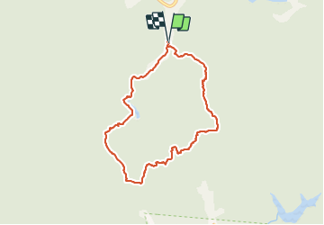
Trail Walking of 9.2 km to be discovered at Jeollabuk-do, Buan-gun. This trail is proposed by dudu42.

Description

Nombreux entablement rocheux avec barrière bois ou métal pour aider dans ces passages difficiles. Beaux points de vue a chaque sommet et paysages colorés.peu de monde dans le sens horaire pour la randonnée.

Elevation profile

Photos

40 photos in total. Please click on a photo to see them all in the gallery.

Positioning

Country:
Korea, Republic of
Region :
Jeollabuk-do
Department/Province :
Buan-gun
Municipality :
Unknown
Location:
Unknown
Start:(UTM)
280948 ; 3946767 (52S) N.

Trails nearby

Trail Walking  - Presqu'île de Daejangdo-ri - Photo
Walking
dudu42

Walking

Easy
, Jeollabuk-do, Gunsan-si, Korea, Republic of
4.5 km | 6.5 km-effort
1h 34min
Yes


Close
My subscriptions