Trail Walking Maintenon - Maintenon - Boucle de l'Eure - Photo

Maintenon - Boucle de l'Eure

partout a pied et en moto

© OpenStreetMap contributors
Length
Length
18.7 km
Max alt
Max alt
144 m
Uphill gradient
Uphill gradient
186 m
Km-Effort
Km-Effort  
21 km
Min alt
Min alt
94 m
Downhill gradient
Downhill gradient
187 m
Boucle
Boucle
Yes
Creation date :
2023-10-02 08:43:42.35
Updated on :
2023-10-02 16:40:03.095

(0 Reviews)

Walking
Walking
4h48
Difficulty : Very difficult

Scan this QR Code to open this trail in the SityTrail application

FREE GPS app for hiking

Logo SityTrail SityTrail

IGN / Geographical institutes

Download SityTrail from the App Store Download SityTrail from Google Play

Logo SityTrail SityTrail World

The world is yours!

Download SityTrail from the App Store Download SityTrail from Google Play Download SityTrail on Huawei AppGallery

About

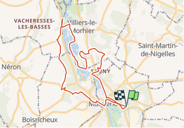
Trail Walking of 18.7 km to be discovered at Centre-Loire Valley, Eure-et-Loir, Maintenon. This trail is proposed by les randos d'Olivier.

Elevation profile

Points of interest

Point of interest Pierres - Rue Jean Monnet - Photo
olivieraron
Point of interest Pierres - Embranchement sortie du bois - Photo
olivieraron
Point of interest Pierres - Cimetière - Photo
olivieraron
PIERRES 
Point of interest Nogent-le-Roi - D101.3 - Photo
olivieraron
NOGENT-LE-ROI 
Point of interest Nogent-le-Roi - Nouvelle déviation - Photo
olivieraron
NOGENT-LE-ROI 
Point of interest Nogent-le-Roi - Château de Nogent-le-Roi - Photo
olivieraron
Point of interest Nogent-le-Roi - Maisons à colombage - Photo
olivieraron
NOGENT-LE-ROI 
Point of interest Villiers-le-Morhier - Petit sentier - Photo
olivieraron
VILLIERS-LE-MORHIER 
Point of interest Villiers-le-Morhier - A droite après le pont sur la - Photo
olivieraron
VILLIERS-LE-MORHIER 
Point of interest Villiers-le-Morhier - Ancien lavoir - Photo
olivieraron
VILLIERS-LE-MORHIER 
Point of interest Maintenon - Parking des bords de la - Photo
olivieraron

Positioning

Country:
France
Region :
Centre-Loire Valley
Department/Province :
Eure-et-Loir
Municipality :
Maintenon
Location:
Unknown
Start:(UTM)
396140 ; 5382306 (31U) N.

Trails nearby

Trail Mountain bike Maintenon - Bois et vallées - Maintenon - Photo
Mountain bike
tracegps

Mountain bike

Easy
(1)
Maintenon, Centre-Loire Valley, Eure-et-Loir, France
12.7 km | 14.7 km-effort
1h 0min
Yes
Trail Walking Saint-Piat - 20200611St Piat - Photo
Walking
Jeanclaudebic

Walking

Very easy
(1)
Saint-Piat, Centre-Loire Valley, Eure-et-Loir, France
10.6 km | 12.5 km-effort
2h 8min
Yes
Trail Walking Maintenon - maintenon - Photo
Walking
topophil

Walking

Very easy
(1)
Maintenon, Centre-Loire Valley, Eure-et-Loir, France
14 km | 16.3 km-effort
3h 5min
Yes
Trail Walking Maintenon - Bois et vallées - Maintenon - Photo
Walking
tracegps

Walking

Difficult
(3)
Maintenon, Centre-Loire Valley, Eure-et-Loir, France
12.7 km | 14.7 km-effort
3h 10min
Yes
Trail Walking Maintenon - Maintenon APL - Photo
Walking
jctbis

Walking

Medium
Maintenon, Centre-Loire Valley, Eure-et-Loir, France
11.5 km | 12.8 km-effort
2h 38min
Yes
Trail Walking Hanches - Hanches  - Photo
Walking
jctbis

Walking

Easy
Hanches, Centre-Loire Valley, Eure-et-Loir, France
11.8 km | 13.2 km-effort
2h 57min
Yes
Trail sport Saint-Piat - Parcours Thierry, Geille Saint-Piat - Photo
sport
ezola

sport

Very easy
Saint-Piat, Centre-Loire Valley, Eure-et-Loir, France
23 km | 27 km-effort
Unknown
Yes
Trail Mountain bike Hanches - hanches Droue sur Drouette st Hilarion - Photo
Mountain bike
topophil

Mountain bike

Difficult
Hanches, Centre-Loire Valley, Eure-et-Loir, France
31 km | 36 km-effort
3h 12min
Yes
Trail Nordic walking Saint-Piat - APL St Piat  - Photo
Nordic walking
jctbis

Nordic walking

Easy
Saint-Piat, Centre-Loire Valley, Eure-et-Loir, France
9.6 km | 11.5 km-effort
2h 1min
Yes


Close
My subscriptions