![](/images/other/stat-length.png)
![Trail Walking Unknown - Presqu'île de Daejangdo-ri - Photo](https://media.geolcdn.com/t/1900/400/ext.pjpeg?maxdim=2&url=https%3A%2F%2Fmedia.geolcdn.com%2Ff%2Ff9988d4f-6f41-443e-9e88-1ff1cd808357.jpg)
Presqu'île de Daejangdo-ri
dudu42
User
![Length](/images/other/stat-length.png)
Length
4.5 km
![Max alt](https://static1.geolcdn.com/siteimages/upload/files/1508320355ic_sort_altitude_max_24dp.png)
Max alt
124 m
![Uphill gradient](https://static1.geolcdn.com/siteimages/upload/files/1508320355ic_sort_den_pos_24dp.png)
Uphill gradient
151 m
![Km-Effort](/images/other/stat-length.png)
Km-Effort
6.5 km
![Min alt](https://static1.geolcdn.com/siteimages/upload/files/1508320355ic_sort_altitude_min_24dp.png)
Min alt
-1 m
![Downhill gradient](https://static1.geolcdn.com/siteimages/upload/files/1508320355ic_sort_den_neg_24dp.png)
Downhill gradient
151 m
![Boucle](https://static1.geolcdn.com/siteimages/upload/files/16400158638029165_repeat_loop_refresh_sync_direction_icon.png)
Boucle
Yes
Creation date :
2023-10-02 03:50:20.062
Updated on :
2023-10-02 06:30:36.161
![Walking](https://static1.geolcdn.com/sitytour/trail-icons/101.png)
1h34
Difficulty : Easy
![Scan this QR Code to open this trail in the SityTrail application](https://capi.geolives.com/qq0zvz2zws4bq2lad0pu/sitytour/trails/3825626/qr.png?size=200)
FREE GPS app for hiking
About
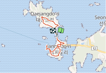
Trail Walking of 4.5 km to be discovered at Jeollabuk-do, Gunsan-si. This trail is proposed by dudu42.
Description
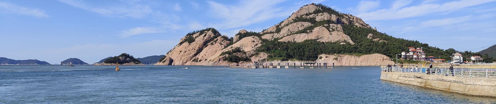
Une randonnée/ballade sur la petite montagne puis un tour au bout de la jetée.
Beaucoup de monde et peu de place de parking donc attente très longue ! et bouchon 😭.
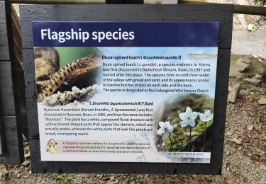
Positioning
Country:
Korea, Republic of
Region :
Jeollabuk-do
Department/Province :
Gunsan-si
Municipality :
Unknown
Location:
Unknown
Start:(Dec)
Start:(UTM)
264834 ; 3966357 (52S) N.
Comments
Trails nearby
![Trail Walking - Randonnée au Peak Gwaneumbong - Photo](https://media.geolcdn.com/t/375/260/ext.jpg?maxdim=2&url=https%3A%2F%2Fmedia.geolcdn.com%2Ff%2Fa56fff14-76e8-4484-b6ad-d17f3c58d9b5.jpg)
![Walking Walking](https://static1.geolcdn.com/sitytour/trail-icons/101.png)
Randonnée au Peak Gwaneumbong
Walking
Difficult
,
Jeollabuk-do,
Buan-gun,
Korea, Republic of
![](/images/other/stat-length.png)
9.2 km | 15.5 km-effort
3h 44min
![](https://static1.geolcdn.com/siteimages/upload/files/16400158638029165_repeat_loop_refresh_sync_direction_icon.png)
Yes