Trail Walking Plan-d'Aups-Sainte-Baume - La Sainte Baume - Les Béguines - Pas de l'Aï - Jouc de l'Aigle - Sint Pilon - Photo

La Sainte Baume - Les Béguines - Pas de l'Aï - Jouc de l'Aigle - Sint Pilon

 pourrier
pourrier

User

© OpenStreetMap contributors
Length
Length
13.9 km
Max alt
Max alt
1138 m
Uphill gradient
Uphill gradient
520 m
Km-Effort
Km-Effort  
21 km
Min alt
Min alt
678 m
Downhill gradient
Downhill gradient
521 m
Boucle
Boucle
Yes
Creation date :
2023-10-01 06:44:19.0
Updated on :
2023-10-02 20:10:31.46

(0 Reviews)

Walking
Walking
4h44
Difficulty : Difficult

Scan this QR Code to open this trail in the SityTrail application

FREE GPS app for hiking

Logo SityTrail SityTrail

IGN / Geographical institutes

Download SityTrail from the App Store Download SityTrail from Google Play

Logo SityTrail SityTrail World

The world is yours!

Download SityTrail from the App Store Download SityTrail from Google Play Download SityTrail on Huawei AppGallery

About

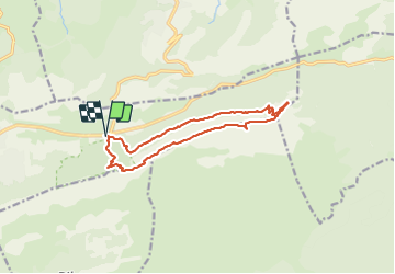
Trail Walking of 13.9 km to be discovered at Provence-Alpes-Côte d'Azur, Var, Plan-d'Aups-Sainte-Baume. This trail is proposed by pourrier.

Description

Départ du parking des 3 chênes et suivre le sentier merveilleux qui longe la Sainte Baume en surplombant les Béguines. Joli sentier forestier.
Rejoindre le pas de l'Aï, et monter sur le plateau de la Sainte Baume. Passage court sans risque en s'aidant des mains.
Pique-nique au Signal des Béguines encore boisées.
Poursuivre la crête jusqu'au Jouc de l'Aigle où des Chèvres du Rove prennent le soleil.
Rejoindre le Col du Saint-Pilon et redescendre avec prudence au début vers La Chapelle des Parisiens et le parking des 3 chênes.

Elevation profile

Positioning

Country:
France
Region :
Provence-Alpes-Côte d'Azur
Department/Province :
Var
Municipality :
Plan-d'Aups-Sainte-Baume
Location:
Unknown
Start:(UTM)
724105 ; 4801770 (31T) N.

Trails nearby

Trail Walking Plan-d'Aups-Sainte-Baume - Sainte Baume 8,5 km - Photo
Walking
GUIDE
rvapeldo

Walking

Medium
(1)
Plan-d'Aups-Sainte-Baume, Provence-Alpes-Côte d'Azur, Var, France
8.4 km | 15.5 km-effort
4h 38min
Yes
Trail Walking Nans-les-Pins - Le baou des glacières - Photo
Walking
GUIDE
amiral13

Walking

Medium
(1)
Nans-les-Pins, Provence-Alpes-Côte d'Azur, Var, France
7.6 km | 12.2 km-effort
4h 27min
Yes
Trail Walking Plan-d'Aups-Sainte-Baume - SityTrail - Sentier merveilleux - La Ste baume - Le Plan d'aups  - Photo
Walking
GUIDE
affinetataille

Walking

Medium
(1)
Plan-d'Aups-Sainte-Baume, Provence-Alpes-Côte d'Azur, Var, France
15 km | 23 km-effort
6h 0min
Yes
Trail Walking Plan-d'Aups-Sainte-Baume - Crêts de la Ste Baume - Photo
Walking
tracegps

Walking

Medium
(2)
Plan-d'Aups-Sainte-Baume, Provence-Alpes-Côte d'Azur, Var, France
15.4 km | 23 km-effort
5h 0min
Yes
Trail Walking Nans-les-Pins - La Croix des Glacières, Sainte-Baume - Photo
Walking
tracegps

Walking

Medium
(1)
Nans-les-Pins, Provence-Alpes-Côte d'Azur, Var, France
7.2 km | 12 km-effort
3h 19min
Yes
Trail Walking Plan-d'Aups-Sainte-Baume - Du Col du Saint-Pilon au Pas de l'Aï, Sainte Baume - Photo
Walking
tracegps

Walking

Medium
(1)
Plan-d'Aups-Sainte-Baume, Provence-Alpes-Côte d'Azur, Var, France
13.1 km | 20 km-effort
5h 15min
Yes
Trail Walking Riboux - Riboux - Forêt de Malaucène - Photo
Walking
tracegps

Walking

Medium
(4)
Riboux, Provence-Alpes-Côte d'Azur, Var, France
12.2 km | 15.2 km-effort
2h 40min
Yes
Trail Walking Plan-d'Aups-Sainte-Baume - La Grotte aux oiseaux - Plan d'Aups  - Photo
Walking
tracegps

Walking

Medium
(1)
Plan-d'Aups-Sainte-Baume, Provence-Alpes-Côte d'Azur, Var, France
8.8 km | 12.5 km-effort
2h 30min
Yes
Trail On foot Plan-d'Aups-Sainte-Baume - Massif Sainte Baume et pas de l’Aï 15 km - Photo
On foot
GUIDE
rvapeldo

On foot

Medium
Plan-d'Aups-Sainte-Baume, Provence-Alpes-Côte d'Azur, Var, France
15 km | 22 km-effort
5h 0min
Yes


Close
My subscriptions