Trail Road bike Le Monestier-du-Percy - Le Percy, lac de Monteynard et Mens en boucle - Photo

Le Percy, lac de Monteynard et Mens en boucle

 scalpy
scalpy

User

© OpenStreetMap contributors
Length
Length
48 km
Max alt
Max alt
891 m
Uphill gradient
Uphill gradient
1040 m
Km-Effort
Km-Effort  
62 km
Min alt
Min alt
521 m
Downhill gradient
Downhill gradient
1040 m
Boucle
Boucle
Yes
Creation date :
2023-09-30 08:31:36.032
Updated on :
2023-09-30 12:55:04.046

(0 Reviews)

Road bike
Road bike
4h22
Difficulty : Very difficult

Scan this QR Code to open this trail in the SityTrail application

FREE GPS app for hiking

Logo SityTrail SityTrail

IGN / Geographical institutes

Download SityTrail from the App Store Download SityTrail from Google Play

Logo SityTrail SityTrail World

The world is yours!

Download SityTrail from the App Store Download SityTrail from Google Play Download SityTrail on Huawei AppGallery

About

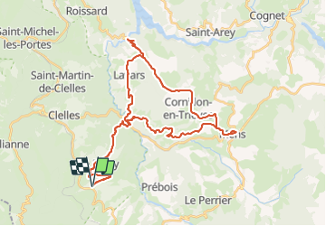
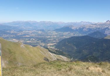
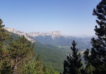
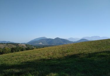
Trail Road bike of 48 km to be discovered at Auvergne-Rhône-Alpes, Isère, Le Monestier-du-Percy. This trail is proposed by scalpy.

Description

très beau tour de vélo, vue en balcon sur le Mont aiguille, l'Obiou et en prime le pont du diable. Top

Elevation profile

Photos

Positioning

Country:
France
Region :
Auvergne-Rhône-Alpes
Department/Province :
Isère
Municipality :
Le Monestier-du-Percy
Location:
Unknown
Start:(UTM)
709218 ; 4962894 (31T) N.

Trails nearby

Trail Walking Chichilianne - Le Platary - Photo
Walking
patjobou

Walking

Medium
(2)
Chichilianne, Auvergne-Rhône-Alpes, Isère, France
6.6 km | 12.1 km-effort
2h 29min
Yes
Trail Walking Châtillon-en-Diois - 26 grimone j1 - Photo
Walking
GUIDE
randodyssée

Walking

Easy
Châtillon-en-Diois, Auvergne-Rhône-Alpes, Drôme, France
14.9 km | 26 km-effort
6h 15min
No
Trail Walking Châtillon-en-Diois - La boucle du Mont Barral - Photo
Walking
GUIDE
R@ph

Walking

Difficult
Châtillon-en-Diois, Auvergne-Rhône-Alpes, Drôme, France
7.5 km | 14.9 km-effort
3h 7min
Yes
Trail Walking Châtillon-en-Diois - mont barral - Photo
Walking
scalpy

Walking

Difficult
Châtillon-en-Diois, Auvergne-Rhône-Alpes, Drôme, France
7.7 km | 15 km-effort
4h 8min
Yes
Trail Walking Châtillon-en-Diois - menée le natal le jocou  - Photo
Walking
Joel26400

Walking

Difficult
Châtillon-en-Diois, Auvergne-Rhône-Alpes, Drôme, France
17.3 km | 34 km-effort
8h 56min
Yes
Trail Walking Châtillon-en-Diois - jocou par le mont Barral depuis le col de Menée   - Photo
Walking
cmarit

Walking

Medium
Châtillon-en-Diois, Auvergne-Rhône-Alpes, Drôme, France
14.5 km | 28 km-effort
8h 35min
Yes
Trail Walking Chichilianne - Tete de Praortzel et Crête de Grande Leirie - Photo
Walking
patjobou

Walking

Difficult
Chichilianne, Auvergne-Rhône-Alpes, Isère, France
12.4 km | 21 km-effort
5h 39min
Yes
Trail Walking Percy - LE PERCU - Photo
Walking
floup6138

Walking

Easy
Percy, Auvergne-Rhône-Alpes, Isère, France
10.1 km | 14.3 km-effort
2h 42min
No
Trail Walking Châtillon-en-Diois - pp mont barral - Photo
Walking
pphilippe

Walking

Medium
Châtillon-en-Diois, Auvergne-Rhône-Alpes, Drôme, France
10.7 km | 19 km-effort
4h 48min
Yes


Close
My subscriptions