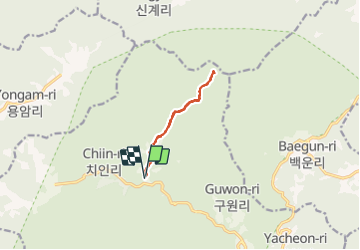
Trail Walking Unknown - Peak Sangwangbong  - Photo
 dudu42
dudu42

User

© OpenStreetMap contributors
Length
Length
11.1 km
Max alt
Max alt
1338 m
Uphill gradient
Uphill gradient
787 m
Km-Effort
Km-Effort  
22 km
Min alt
Min alt
545 m
Downhill gradient
Downhill gradient
787 m
Boucle
Boucle
Yes
Creation date :
2023-09-27 00:53:38.632
Updated on :
2023-09-27 06:52:34.669

(0 Reviews)

Walking
Walking
4h18
Difficulty : Difficult

Scan this QR Code to open this trail in the SityTrail application

FREE GPS app for hiking

Logo SityTrail SityTrail

IGN / Geographical institutes

Download SityTrail from the App Store Download SityTrail from Google Play

Logo SityTrail SityTrail World

The world is yours!

Download SityTrail from the App Store Download SityTrail from Google Play Download SityTrail on Huawei AppGallery

About

Trail Walking of 11.1 km to be discovered at Gyeongsangnam-do, Hapcheon-gun. This trail is proposed by dudu42.

Description

Parcours agréable en sous bois le long du torrent. Chemin de terre au début puis marches en pierre alternant avec des escaliers en bois. Montée régulière puis accentuation de la pente vers la fin. Belle vue panoramique si le temps le permet !. Au retour , n'oubliez pas de visiter le temple.

Elevation profile

Photos

30 photos in total. Please click on a photo to see them all in the gallery.

Positioning

Country:
Korea, Republic of
Region :
Gyeongsangnam-do
Department/Province :
Hapcheon-gun
Municipality :
Unknown
Location:
Unknown
Start:(UTM)
418160 ; 3961452 (52S) N.

Trails nearby


Close
My subscriptions