![](/images/other/stat-length.png)
![Trail On foot Saint-Denis-de-Jouhet - Circuit pédestre](https://media.geolcdn.com/t/1900/400/ext.pjpeg?maxdim=2&url=https%3A%2F%2Fstatic1.geolcdn.com%2Fsiteimages%2Fupload%2Ffiles%2F1545311037marcheuse_200dpi.jpg)
Circuit pédestre "moulins et croix"
fanthou
User
![Length](/images/other/stat-length.png)
Length
5.5 km
![Max alt](https://static1.geolcdn.com/siteimages/upload/files/1508320355ic_sort_altitude_max_24dp.png)
Max alt
303 m
![Uphill gradient](https://static1.geolcdn.com/siteimages/upload/files/1508320355ic_sort_den_pos_24dp.png)
Uphill gradient
76 m
![Km-Effort](/images/other/stat-length.png)
Km-Effort
6.5 km
![Min alt](https://static1.geolcdn.com/siteimages/upload/files/1508320355ic_sort_altitude_min_24dp.png)
Min alt
246 m
![Downhill gradient](https://static1.geolcdn.com/siteimages/upload/files/1508320355ic_sort_den_neg_24dp.png)
Downhill gradient
76 m
![Boucle](https://static1.geolcdn.com/siteimages/upload/files/16400158638029165_repeat_loop_refresh_sync_direction_icon.png)
Boucle
Yes
Creation date :
2023-09-26 16:07:22.767
Updated on :
2023-09-26 16:08:19.848
![On foot](https://static1.geolcdn.com/sitytour/trail-icons/100.png)
1h28
Difficulty : Easy
![Scan this QR Code to open this trail in the SityTrail application](https://capi.geolives.com/qq0zvz2zws4bq2lad0pu/sitytour/trails/3819430/qr.png?size=200)
FREE GPS app for hiking
About
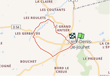
Trail On foot of 5.5 km to be discovered at Centre-Loire Valley, Indre, Saint-Denis-de-Jouhet. This trail is proposed by fanthou.
Description
Circuit autour de la commune de Saint-Denis-de-Jouhet à la découverte des moulins et croix jalonnant la vallée du Gourdon. Téléchargement du circuit dans la rubrique "accès site web".
Positioning
Country:
France
Region :
Centre-Loire Valley
Department/Province :
Indre
Municipality :
Saint-Denis-de-Jouhet
Location:
Unknown
Start:(Dec)
Start:(UTM)
413301 ; 5153643 (31T) N.
Comments
Trails nearby
![Trail Walking Crozon-sur-Vauvre - Circuit pédestre](https://media.geolcdn.com/t/375/260/ext.jpg?maxdim=2&url=https%3A%2F%2Fstatic1.geolcdn.com%2Fsiteimages%2Fupload%2Ffiles%2F1553511878bg_sport_marche.png)
![Walking Walking](https://static1.geolcdn.com/sitytour/trail-icons/101.png)
Circuit pédestre "sortilèges et légendes"
Walking
Easy
Crozon-sur-Vauvre,
Centre-Loire Valley,
Indre,
France
![](/images/other/stat-length.png)
11.3 km | 14.1 km-effort
3h 11min
![](https://static1.geolcdn.com/siteimages/upload/files/16400158638029165_repeat_loop_refresh_sync_direction_icon.png)
Yes
![Trail Walking Chassignolles - Un peu de Vauvre - Photo](https://media.geolcdn.com/t/375/260/ext.jpg?maxdim=2&url=https%3A%2F%2Fstatic1.geolcdn.com%2Fsiteimages%2Fupload%2Ffiles%2F1553511878bg_sport_marche.png)
![Walking Walking](https://static1.geolcdn.com/sitytour/trail-icons/101.png)
Un peu de Vauvre
Walking
Very easy
Chassignolles,
Centre-Loire Valley,
Indre,
France
![](/images/other/stat-length.png)
4.8 km | 5.5 km-effort
1h 12min
![](https://static1.geolcdn.com/siteimages/upload/files/16400158638029165_repeat_loop_refresh_sync_direction_icon.png)
Yes