![](/images/other/stat-length.png)
![Trail Walking Bernay - Bernay - Circuit du Mont Rose - GD - Photo](https://media.geolcdn.com/t/1900/400/ext.pjpeg?maxdim=2&url=https%3A%2F%2Fstatic1.geolcdn.com%2Fsiteimages%2Fupload%2Ffiles%2F1553511878bg_sport_marche.png)
Bernay - Circuit du Mont Rose - GD
philippe76
User
![Length](/images/other/stat-length.png)
![Max alt](https://static1.geolcdn.com/siteimages/upload/files/1508320355ic_sort_altitude_max_24dp.png)
![Uphill gradient](https://static1.geolcdn.com/siteimages/upload/files/1508320355ic_sort_den_pos_24dp.png)
![Km-Effort](/images/other/stat-length.png)
![Min alt](https://static1.geolcdn.com/siteimages/upload/files/1508320355ic_sort_altitude_min_24dp.png)
![Downhill gradient](https://static1.geolcdn.com/siteimages/upload/files/1508320355ic_sort_den_neg_24dp.png)
![Boucle](https://static1.geolcdn.com/siteimages/upload/files/16400158638029165_repeat_loop_refresh_sync_direction_icon.png)
![Walking](https://static1.geolcdn.com/sitytour/trail-icons/101.png)
2h26
Difficulty : Medium
![Scan this QR Code to open this trail in the SityTrail application](https://capi.geolives.com/qq0zvz2zws4bq2lad0pu/sitytour/trails/3817671/qr.png?size=200)
FREE GPS app for hiking
About
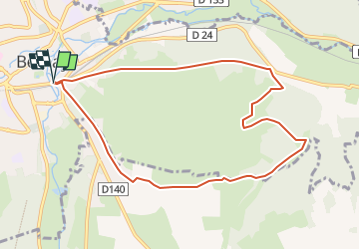
Trail Walking of 8.9 km to be discovered at Normandy, Eure, Bernay. This trail is proposed by philippe76.
Description
Départ à la gare - grand Parking 50 m avant la gare.
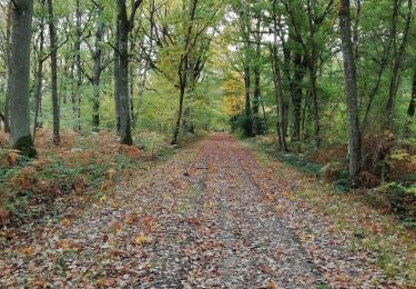
descendre le boulevard DUBUS; aller jusqu'au 3ème passage souterrain, passer sous la voie ferrée. Traverser la place DUPONT DE L'EURE, la rue jacques DAVIEL et monter le chemin de ST CLAIR.
Prendre à gauche le chemin de la Briqueterie, puis le chemin de la Charmille, c'est le GRP de Pays RISLE-CHARENTONNE.
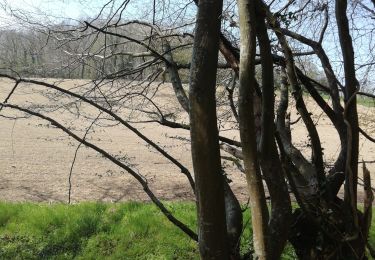
Suivre en face un chemin de terre jusqu'à LA TOURANGERIE, continuer le chemin qui descend dans la vallée.
Au point 111 de la carte prendre à gauche le chemin vers LA BROUTINIERE; AD IMPASSE DES BRUGES,AD rue de LA FORET,
PRENDRE AG vers LE HARAS, puis continuer TD la rue DU CHAMP DE COURSE. REVENIR A LA GARE par le même chemin.
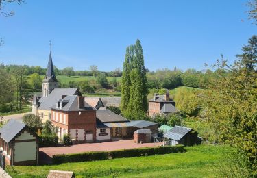
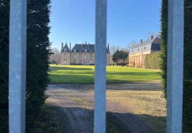
OPTION : aller voir le château au HAUT BOUFFEY
Positioning
Comments
Trails nearby
![Trail Electric bike Menneval - Menneval Saint aubin du theney - Photo](https://media.geolcdn.com/t/375/260/a793e96f-ac1d-4c22-9a70-0ce347279999.jpg&format=jpg&maxdim=2)
![Electric bike Electric bike](https://static1.geolcdn.com/sitytour/trail-icons/205.png)
Electric bike
![](/images/other/stat-length.png)
![](https://static1.geolcdn.com/siteimages/upload/files/16400158638029165_repeat_loop_refresh_sync_direction_icon.png)
![Trail sport Treis-Sants-en-Ouche - St Aubin le vertueux - Photo](https://media.geolcdn.com/t/375/260/02e6ec88-366b-41c8-8e5f-da78b5becd4e.jpg&format=jpg&maxdim=2)
sport
![](/images/other/stat-length.png)
![](https://static1.geolcdn.com/siteimages/upload/files/16400158638029165_repeat_loop_refresh_sync_direction_icon.png)
![Trail Hybrid bike Menneval - fontaine l'abbé - Photo](https://media.geolcdn.com/t/375/260/ext.jpg?maxdim=2&url=https%3A%2F%2Fstatic1.geolcdn.com%2Fsiteimages%2Fupload%2Ffiles%2F1524743154velo.jpg)
![Hybrid bike Hybrid bike](https://static1.geolcdn.com/sitytour/trail-icons/203.png)
Hybrid bike
![](/images/other/stat-length.png)
![](https://static1.geolcdn.com/siteimages/upload/files/16400158638029165_repeat_loop_refresh_sync_direction_icon.png)
![Trail Walking Valailles - Autour de Valailles - Photo](https://media.geolcdn.com/t/375/260/e3509089-bb56-47ac-bcad-158a3b8521a0.jpg&format=jpg&maxdim=2)
![Walking Walking](https://static1.geolcdn.com/sitytour/trail-icons/101.png)
Walking
![](/images/other/stat-length.png)
![](https://static1.geolcdn.com/siteimages/upload/files/16400158638029165_repeat_loop_refresh_sync_direction_icon.png)
![Trail Horseback riding Saint-Léger-de-Rôtes - rando equestre st leger de roste - Photo](https://media.geolcdn.com/t/375/260/253950bc-7c04-4aa1-8dde-5d89de207197.jpg&format=jpg&maxdim=2)
![Horseback riding Horseback riding](https://static1.geolcdn.com/sitytour/trail-icons/301.png)
Horseback riding
![](/images/other/stat-length.png)
![](https://static1.geolcdn.com/siteimages/upload/files/16400158638029165_repeat_loop_refresh_sync_direction_icon.png)
![Trail Walking Bernay - bernay 19 decembre 2015 - Photo](https://media.geolcdn.com/t/375/260/ext.jpg?maxdim=2&url=https%3A%2F%2Fstatic1.geolcdn.com%2Fsiteimages%2Fupload%2Ffiles%2F1553511878bg_sport_marche.png)
![Walking Walking](https://static1.geolcdn.com/sitytour/trail-icons/101.png)
Walking
![](/images/other/stat-length.png)
![](https://static1.geolcdn.com/siteimages/upload/files/16400158638029165_repeat_loop_refresh_sync_direction_icon.png)
![Trail Motor Bernay - corneville 4 modifié 2 - Photo](https://media.geolcdn.com/t/375/260/ext.jpg?maxdim=2&url=https%3A%2F%2Fstatic1.geolcdn.com%2Fsiteimages%2Fupload%2Ffiles%2F15247431544x4.jpg)
![Motor Motor](https://static1.geolcdn.com/sitytour/trail-icons/400.png)
Motor
![](/images/other/stat-length.png)
![](https://static1.geolcdn.com/siteimages/upload/files/16400158638029165_repeat_loop_refresh_sync_direction_icon.png)
![Trail sport Saint-Léger-de-Rôtes - St Léger de R - Photo](https://media.geolcdn.com/t/375/260/e73130ce-651a-4f03-b5b0-097fb7e830d0.jpg&format=jpg&maxdim=2)
sport
![](/images/other/stat-length.png)
![](https://static1.geolcdn.com/siteimages/upload/files/16400158638029165_repeat_loop_refresh_sync_direction_icon.png)
![Trail Walking Bernay - Champeaux bis - Photo](https://media.geolcdn.com/t/375/260/01cad62d-f018-4394-bec6-5e039149be7c.jpg&format=jpg&maxdim=2)
![Walking Walking](https://static1.geolcdn.com/sitytour/trail-icons/101.png)