![](/images/other/stat-length.png)
![Trail Walking Cajarc - Carjac Limogne Varaire - Photo](https://media.geolcdn.com/t/1900/400/ext.pjpeg?maxdim=2&url=https%3A%2F%2Fstatic1.geolcdn.com%2Fsiteimages%2Fupload%2Ffiles%2F1553511878bg_sport_marche.png)
Carjac Limogne Varaire
Nono55
User
![Length](/images/other/stat-length.png)
Length
30 km
![Max alt](https://static1.geolcdn.com/siteimages/upload/files/1508320355ic_sort_altitude_max_24dp.png)
Max alt
382 m
![Uphill gradient](https://static1.geolcdn.com/siteimages/upload/files/1508320355ic_sort_den_pos_24dp.png)
Uphill gradient
643 m
![Km-Effort](/images/other/stat-length.png)
Km-Effort
39 km
![Min alt](https://static1.geolcdn.com/siteimages/upload/files/1508320355ic_sort_altitude_min_24dp.png)
Min alt
142 m
![Downhill gradient](https://static1.geolcdn.com/siteimages/upload/files/1508320355ic_sort_den_neg_24dp.png)
Downhill gradient
485 m
![Boucle](https://static1.geolcdn.com/siteimages/upload/files/16400158638029165_repeat_loop_refresh_sync_direction_icon.png)
Boucle
No
Creation date :
2023-09-24 05:52:00.0
Updated on :
2023-09-24 15:23:54.474
![Walking](https://static1.geolcdn.com/sitytour/trail-icons/101.png)
6h29
Difficulty : Easy
![Scan this QR Code to open this trail in the SityTrail application](https://capi.geolives.com/qq0zvz2zws4bq2lad0pu/sitytour/trails/3816864/qr.png?size=200)
FREE GPS app for hiking
About
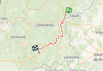
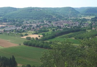
Trail Walking of 30 km to be discovered at Occitania, Lot, Cajarc. This trail is proposed by Nono55.
Description
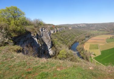
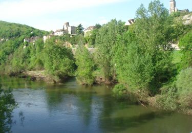
Très belle étape départ tôt le matin le long du Lot
Levée de soleil avec brume magique
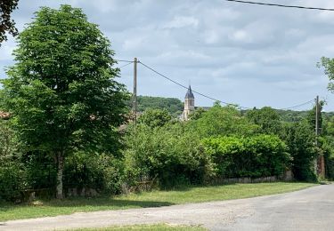
Traversée de beau village
Chemins avec murets de pierre très jolie
Une belle région le Quercy
Positioning
Country:
France
Region :
Occitania
Department/Province :
Lot
Municipality :
Cajarc
Location:
Unknown
Start:(Dec)
Start:(UTM)
408197 ; 4927133 (31T) N.
Comments
Trails nearby
![Walking Walking](https://static1.geolcdn.com/sitytour/trail-icons/101.png)
Saujac-Bastides et Gorges de l'Aveyron
Walking
Difficult
(1)
Saujac,
Occitania,
Aveyron,
France
![](/images/other/stat-length.png)
9.7 km | 13 km-effort
2h 56min
![](https://static1.geolcdn.com/siteimages/upload/files/16400158638029165_repeat_loop_refresh_sync_direction_icon.png)
Yes
![Trail Walking Cajarc - Etape14 Cajarc a Limogne en Quercy - Photo](https://media.geolcdn.com/t/375/260/405db016-7b74-4610-ae5a-c0cd886f3823.jpg&format=jpg&maxdim=2)
![Walking Walking](https://static1.geolcdn.com/sitytour/trail-icons/101.png)
Etape14 Cajarc a Limogne en Quercy
Walking
Easy
Cajarc,
Occitania,
Lot,
France
![](/images/other/stat-length.png)
19.4 km | 25 km-effort
4h 36min
![](https://static1.geolcdn.com/siteimages/upload/files/16400158638029165_repeat_loop_refresh_sync_direction_icon.png)
No
![Trail Walking Cajarc - Le Lot à Cajarc - Photo](https://media.geolcdn.com/t/375/260/4edfb6ba-77c2-4b7c-8112-ab3fdf722c8d.jpg&format=jpg&maxdim=2)
![Walking Walking](https://static1.geolcdn.com/sitytour/trail-icons/101.png)
CC_Velay_DA_13_Cajarc_Bach_20080504
Walking
Medium
Cajarc,
Occitania,
Lot,
France
![](/images/other/stat-length.png)
32 km | 40 km-effort
7h 20min
![](https://static1.geolcdn.com/siteimages/upload/files/16400158638029165_repeat_loop_refresh_sync_direction_icon.png)
No
![Trail Walking Cajarc - Cajarc (Boucle) - Photo](https://media.geolcdn.com/t/375/260/31c50ab7-35e1-42d8-ab88-02ad408a7081.jpg&format=jpg&maxdim=2)
![Walking Walking](https://static1.geolcdn.com/sitytour/trail-icons/101.png)
Cajarc (Boucle)
Walking
Difficult
Cajarc,
Occitania,
Lot,
France
![](/images/other/stat-length.png)
12.6 km | 17 km-effort
3h 39min
![](https://static1.geolcdn.com/siteimages/upload/files/16400158638029165_repeat_loop_refresh_sync_direction_icon.png)
Yes
![Trail Walking Calvignac - calvignac cenevieres - Photo](https://media.geolcdn.com/t/375/260/ext.jpg?maxdim=2&url=https%3A%2F%2Fservices.sitytrail.com%2FGeolivesWS%2FDownloadMedia.ashx%3FTrailID%3D862044%26Media%3D1e5e8998-a61f-47a3-8fe1-bc246c2d63f9.jpg)
![Walking Walking](https://static1.geolcdn.com/sitytour/trail-icons/101.png)
calvignac cenevieres
Walking
Medium
Calvignac,
Occitania,
Lot,
France
![](/images/other/stat-length.png)
19.4 km | 28 km-effort
5h 29min
![](https://static1.geolcdn.com/siteimages/upload/files/16400158638029165_repeat_loop_refresh_sync_direction_icon.png)
Yes
![Trail Walking Cajarc - cajarc - Photo](https://media.geolcdn.com/t/375/260/d19882e9-28c7-447d-bfa5-126d995ee0b2.jpg&format=jpg&maxdim=2)
![Walking Walking](https://static1.geolcdn.com/sitytour/trail-icons/101.png)
![Trail Walking Salvagnac-Cajarc - roc de lantouy2024 - Photo](https://media.geolcdn.com/t/375/260/ext.jpg?maxdim=2&url=https%3A%2F%2Fstatic1.geolcdn.com%2Fsiteimages%2Fupload%2Ffiles%2F1553511878bg_sport_marche.png)
![Walking Walking](https://static1.geolcdn.com/sitytour/trail-icons/101.png)
roc de lantouy2024
Walking
Difficult
Salvagnac-Cajarc,
Occitania,
Aveyron,
France
![](/images/other/stat-length.png)
10.5 km | 15.3 km-effort
2h 55min
![](https://static1.geolcdn.com/siteimages/upload/files/16400158638029165_repeat_loop_refresh_sync_direction_icon.png)
Yes
![Trail Walking Saint-Chels - St chels - Photo](https://media.geolcdn.com/t/375/260/ext.jpg?maxdim=2&url=https%3A%2F%2Fstatic1.geolcdn.com%2Fsiteimages%2Fupload%2Ffiles%2F1553511878bg_sport_marche.png)
![Walking Walking](https://static1.geolcdn.com/sitytour/trail-icons/101.png)
St chels
Walking
Very difficult
Saint-Chels,
Occitania,
Lot,
France
![](/images/other/stat-length.png)
18.7 km | 25 km-effort
4h 40min
![](https://static1.geolcdn.com/siteimages/upload/files/16400158638029165_repeat_loop_refresh_sync_direction_icon.png)
Yes