![](/images/other/stat-length.png)
![Trail Walking Pájara - LZ6 - Arco de Las Penitas (L'arche des Penitas . Lanzarote) - Photo](https://media.geolcdn.com/t/1900/400/c561f42e-001d-4965-8eee-d678c9b59faf.jpg&format=pjpeg&maxdim=2)
LZ6 - Arco de Las Penitas (L'arche des Penitas . Lanzarote)
patjobou
User
![Length](/images/other/stat-length.png)
Length
2.2 km
![Max alt](https://static1.geolcdn.com/siteimages/upload/files/1508320355ic_sort_altitude_max_24dp.png)
Max alt
223 m
![Uphill gradient](https://static1.geolcdn.com/siteimages/upload/files/1508320355ic_sort_den_pos_24dp.png)
Uphill gradient
91 m
![Km-Effort](/images/other/stat-length.png)
Km-Effort
3.4 km
![Min alt](https://static1.geolcdn.com/siteimages/upload/files/1508320355ic_sort_altitude_min_24dp.png)
Min alt
127 m
![Downhill gradient](https://static1.geolcdn.com/siteimages/upload/files/1508320355ic_sort_den_neg_24dp.png)
Downhill gradient
91 m
![Boucle](https://static1.geolcdn.com/siteimages/upload/files/16400158638029165_repeat_loop_refresh_sync_direction_icon.png)
Boucle
Yes
Creation date :
2023-09-23 14:52:14.572
Updated on :
2023-09-30 20:36:19.289
![Walking](https://static1.geolcdn.com/sitytour/trail-icons/101.png)
49m
Difficulty : Medium
![Scan this QR Code to open this trail in the SityTrail application](https://capi.geolives.com/qq0zvz2zws4bq2lad0pu/sitytour/trails/3815827/qr.png?size=200)
FREE GPS app for hiking
About
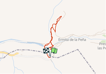
Trail Walking of 2.2 km to be discovered at Canary Islands, Las Palmas, Pájara. This trail is proposed by patjobou.
Description
Ou presque.
Belle randonnée qui mène à un point remarquable.
Le chemin est à peu près bien tracé au départ, puis il se redresse, et il faut le chercher. Il faut mettre les mains sur la fin, et être bien chaussé. Plus la chaleur, nous nous arrêterons 90m avant de sommet, pas prudence.
Belle balade qund même.
Positioning
Country:
Spain
Region :
Canary Islands
Department/Province :
Las Palmas
Municipality :
Pájara
Location:
Unknown
Start:(Dec)
Start:(UTM)
587577 ; 3140288 (28R) N.
Comments
Trails nearby
![Trail Walking Betancuria - Hermitage+arche - Photo](https://media.geolcdn.com/t/375/260/ext.jpg?maxdim=2&url=https%3A%2F%2Fstatic1.geolcdn.com%2Fsiteimages%2Fupload%2Ffiles%2F1553511878bg_sport_marche.png)
![Walking Walking](https://static1.geolcdn.com/sitytour/trail-icons/101.png)
Hermitage+arche
Walking
Difficult
Betancuria,
Canary Islands,
Las Palmas,
Spain
![](/images/other/stat-length.png)
6.7 km | 9.7 km-effort
3h 46min
![](https://static1.geolcdn.com/siteimages/upload/files/16400158638029165_repeat_loop_refresh_sync_direction_icon.png)
Yes
![Trail Walking Betancuria - Betancuria - Photo](https://media.geolcdn.com/t/375/260/ext.jpg?maxdim=2&url=https%3A%2F%2Fstatic1.geolcdn.com%2Fsiteimages%2Fupload%2Ffiles%2F1553511878bg_sport_marche.png)
![Walking Walking](https://static1.geolcdn.com/sitytour/trail-icons/101.png)
Betancuria
Walking
Very difficult
Betancuria,
Canary Islands,
Las Palmas,
Spain
![](/images/other/stat-length.png)
14.3 km | 25 km-effort
5h 41min
![](https://static1.geolcdn.com/siteimages/upload/files/16400158638029165_repeat_loop_refresh_sync_direction_icon.png)
No
![Trail Walking Pájara - Ajuy vers le sud - Photo](https://media.geolcdn.com/t/375/260/ext.jpg?maxdim=2&url=https%3A%2F%2Fstatic1.geolcdn.com%2Fsiteimages%2Fupload%2Ffiles%2F1553511878bg_sport_marche.png)
![Walking Walking](https://static1.geolcdn.com/sitytour/trail-icons/101.png)
Ajuy vers le sud
Walking
Easy
Pájara,
Canary Islands,
Las Palmas,
Spain
![](/images/other/stat-length.png)
5.3 km | 6.8 km-effort
1h 54min
![](https://static1.geolcdn.com/siteimages/upload/files/16400158638029165_repeat_loop_refresh_sync_direction_icon.png)
Yes