![](/images/other/stat-length.png)
![Trail Horseback riding Unknown - 22 septembre 23. Avec Florence - Photo](https://media.geolcdn.com/t/1900/400/ext.pjpeg?maxdim=2&url=https%3A%2F%2Fstatic1.geolcdn.com%2Fsiteimages%2Fupload%2Ffiles%2F1524743154cheval.jpg)
22 septembre 23. Avec Florence
roi
User
![Length](/images/other/stat-length.png)
Length
19.5 km
![Max alt](https://static1.geolcdn.com/siteimages/upload/files/1508320355ic_sort_altitude_max_24dp.png)
Max alt
99 m
![Uphill gradient](https://static1.geolcdn.com/siteimages/upload/files/1508320355ic_sort_den_pos_24dp.png)
Uphill gradient
144 m
![Km-Effort](/images/other/stat-length.png)
Km-Effort
21 km
![Min alt](https://static1.geolcdn.com/siteimages/upload/files/1508320355ic_sort_altitude_min_24dp.png)
Min alt
39 m
![Downhill gradient](https://static1.geolcdn.com/siteimages/upload/files/1508320355ic_sort_den_neg_24dp.png)
Downhill gradient
143 m
![Boucle](https://static1.geolcdn.com/siteimages/upload/files/16400158638029165_repeat_loop_refresh_sync_direction_icon.png)
Boucle
Yes
Creation date :
2023-09-22 07:42:57.0
Updated on :
2023-09-22 11:19:38.657
![Horseback riding](https://static1.geolcdn.com/sitytour/trail-icons/301.png)
3h35
Difficulty : Very easy
![Scan this QR Code to open this trail in the SityTrail application](https://capi.geolives.com/qq0zvz2zws4bq2lad0pu/sitytour/trails/3814451/qr.png?size=200)
FREE GPS app for hiking
About
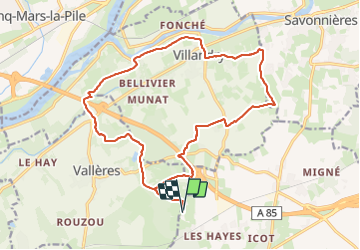
Trail Horseback riding of 19.5 km to be discovered at Centre-Loire Valley, Indre-et-Loire. This trail is proposed by roi.
Description
Du connu mais cool. Bcp de pas rapide que roi avait du mal à suivre !
Passage au retour sous le pont de l’autoroute. Très bruyant mais de la place
Positioning
Country:
France
Region :
Centre-Loire Valley
Department/Province :
Indre-et-Loire
Municipality :
Unknown
Location:
Unknown
Start:(Dec)
Start:(UTM)
311402 ; 5241806 (31T) N.
Comments
Trails nearby
![Walking Walking](https://static1.geolcdn.com/sitytour/trail-icons/101.png)
Villandry - 2015 05 24
Walking
Easy
(1)
Villandry,
Centre-Loire Valley,
Indre-et-Loire,
France
![](/images/other/stat-length.png)
4.9 km | 5.7 km-effort
1h 15min
![](https://static1.geolcdn.com/siteimages/upload/files/16400158638029165_repeat_loop_refresh_sync_direction_icon.png)
Yes
![Trail Walking Vallères - Vallères le Hay - Zig zag Lignières-de-Touraine - 27.2km 300m 6h00 (50mn) - 2024 06 05 - Photo](https://media.geolcdn.com/t/375/260/b3324c15-4c92-4d98-acdf-5b4b32a3e010.jpg&format=jpg&maxdim=2)
![Walking Walking](https://static1.geolcdn.com/sitytour/trail-icons/101.png)
Vallères le Hay - Zig zag Lignières-de-Touraine - 27.2km 300m 6h00 (50mn) - 2...
Walking
Medium
Vallères,
Centre-Loire Valley,
Indre-et-Loire,
France
![](/images/other/stat-length.png)
27 km | 31 km-effort
6h 0min
![](https://static1.geolcdn.com/siteimages/upload/files/16400158638029165_repeat_loop_refresh_sync_direction_icon.png)
Yes
![Trail Walking Vallères - Vallères - Zig zag Manoir de Fontenay - 26.2km 350m 6h00 (35mn) - 2024 05 31 - Photo](https://media.geolcdn.com/t/375/260/2dd7bae2-e64d-4c31-aa25-080d87181237.jpg&format=jpg&maxdim=2)
![Walking Walking](https://static1.geolcdn.com/sitytour/trail-icons/101.png)
Vallères - Zig zag Manoir de Fontenay - 26.2km 350m 6h00 (35mn) - 2024 05 31
Walking
Easy
Vallères,
Centre-Loire Valley,
Indre-et-Loire,
France
![](/images/other/stat-length.png)
26 km | 31 km-effort
6h 0min
![](https://static1.geolcdn.com/siteimages/upload/files/16400158638029165_repeat_loop_refresh_sync_direction_icon.png)
Yes
![Trail Walking Cinq-Mars-la-Pile - Cinq-Mars-la-Pile - Langeais - 14km 205m 3h05 - 2024 02 14 - Photo](https://media.geolcdn.com/t/375/260/bfe42b2e-405a-46df-8533-fbac70b0d338.jpg&format=jpg&maxdim=2)
![Walking Walking](https://static1.geolcdn.com/sitytour/trail-icons/101.png)
Cinq-Mars-la-Pile - Langeais - 14km 205m 3h05 - 2024 02 14
Walking
Easy
Cinq-Mars-la-Pile,
Centre-Loire Valley,
Indre-et-Loire,
France
![](/images/other/stat-length.png)
14 km | 16.7 km-effort
3h 5min
![](https://static1.geolcdn.com/siteimages/upload/files/16400158638029165_repeat_loop_refresh_sync_direction_icon.png)
Yes
![Trail Walking Azay-le-Rideau - Azay-le-Rideau - Goupillières Baulay - 15.1km 185m 3h35 - 2022 07 12 - Photo](https://media.geolcdn.com/t/375/260/8707bc61-0cf0-4af2-87b1-fc906fb58702.jpg&format=jpg&maxdim=2)
![Walking Walking](https://static1.geolcdn.com/sitytour/trail-icons/101.png)
Azay-le-Rideau - Goupillières Baulay - 15.1km 185m 3h35 - 2022 07 12
Walking
Easy
Azay-le-Rideau,
Centre-Loire Valley,
Indre-et-Loire,
France
![](/images/other/stat-length.png)
15.1 km | 17.6 km-effort
3h 35min
![](https://static1.geolcdn.com/siteimages/upload/files/16400158638029165_repeat_loop_refresh_sync_direction_icon.png)
Yes
![Trail Walking Savonnières - Savonnières - les Fontaines GR3 et PRs - 20.1km 190m 4h40 - 2022 05 12 - Photo](https://media.geolcdn.com/t/375/260/58a53b1f-8878-4695-8af8-d5fb36baa215.jpg&format=jpg&maxdim=2)
![Walking Walking](https://static1.geolcdn.com/sitytour/trail-icons/101.png)
Savonnières - les Fontaines GR3 et PRs - 20.1km 190m 4h40 - 2022 05 12
Walking
Easy
Savonnières,
Centre-Loire Valley,
Indre-et-Loire,
France
![](/images/other/stat-length.png)
20 km | 23 km-effort
4h 40min
![](https://static1.geolcdn.com/siteimages/upload/files/16400158638029165_repeat_loop_refresh_sync_direction_icon.png)
Yes
![Trail Walking Vallères - Vallères - Circuit 11km - 10.7km 115m 2h20 - 2020 07 11 - Photo](https://media.geolcdn.com/t/375/260/dacfb651-3bef-48cd-bbc1-bfa3f2be3086.jpg&format=jpg&maxdim=2)
![Walking Walking](https://static1.geolcdn.com/sitytour/trail-icons/101.png)
Vallères - Circuit 11km - 10.7km 115m 2h20 - 2020 07 11
Walking
Very easy
Vallères,
Centre-Loire Valley,
Indre-et-Loire,
France
![](/images/other/stat-length.png)
10.7 km | 12.2 km-effort
2h 20min
![](https://static1.geolcdn.com/siteimages/upload/files/16400158638029165_repeat_loop_refresh_sync_direction_icon.png)
Yes
![Trail Walking - Druye - Sentier du menhir - 14km 95m 2h50 - 2019 08 03 - Photo](https://media.geolcdn.com/t/375/260/c6989684-aee6-4647-b6d8-0c0e44444f1d.jpg&format=jpg&maxdim=2)
![Walking Walking](https://static1.geolcdn.com/sitytour/trail-icons/101.png)
Druye - Sentier du menhir - 14km 95m 2h50 - 2019 08 03
Walking
Very easy
,
Centre-Loire Valley,
Indre-et-Loire,
France
![](/images/other/stat-length.png)
14 km | 15.2 km-effort
2h 50min
![](https://static1.geolcdn.com/siteimages/upload/files/16400158638029165_repeat_loop_refresh_sync_direction_icon.png)
Yes
![Trail Walking Villandry - Villandry - Vallée du Vau - GR3 - 2016 02 27 - Photo](https://media.geolcdn.com/t/375/260/b4bedcce-c3ef-4637-9d7c-92bc166e5e4b.jpg&format=jpg&maxdim=2)
![Walking Walking](https://static1.geolcdn.com/sitytour/trail-icons/101.png)
Villandry - Vallée du Vau - GR3 - 2016 02 27
Walking
Easy
Villandry,
Centre-Loire Valley,
Indre-et-Loire,
France
![](/images/other/stat-length.png)
12.2 km | 14.4 km-effort
3h 0min
![](https://static1.geolcdn.com/siteimages/upload/files/16400158638029165_repeat_loop_refresh_sync_direction_icon.png)
Yes