![](/images/other/stat-length.png)
![Trail Barles - 2023-09-27 Rando CVA Monges Barles vers Col de Fontbelle - Photo](https://media.geolcdn.com/t/1900/400/ext.pjpeg?maxdim=2&url=https%3A%2F%2Fsecurestorage.geolives.com%2Fsitytour%2Ftrail-bg%2Fdefault.jpg)
2023-09-27 Rando CVA Monges Barles vers Col de Fontbelle
Suroit
User
![Length](/images/other/stat-length.png)
![Max alt](https://static1.geolcdn.com/siteimages/upload/files/1508320355ic_sort_altitude_max_24dp.png)
![Uphill gradient](https://static1.geolcdn.com/siteimages/upload/files/1508320355ic_sort_den_pos_24dp.png)
![Km-Effort](/images/other/stat-length.png)
![Min alt](https://static1.geolcdn.com/siteimages/upload/files/1508320355ic_sort_altitude_min_24dp.png)
![Downhill gradient](https://static1.geolcdn.com/siteimages/upload/files/1508320355ic_sort_den_neg_24dp.png)
![Boucle](https://static1.geolcdn.com/siteimages/upload/files/16400158638029165_repeat_loop_refresh_sync_direction_icon.png)
![Scan this QR Code to open this trail in the SityTrail application](https://capi.geolives.com/qq0zvz2zws4bq2lad0pu/sitytour/trails/3813461/qr.png?size=200)
FREE GPS app for hiking
About
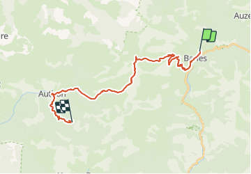
Trail of 26 km to be discovered at Provence-Alpes-Côte d'Azur, Alpes-de-Haute-Provence, Barles. This trail is proposed by Suroit.
Description
Barles vers Col de Fontbelle
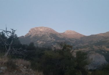
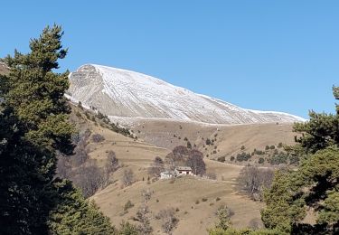
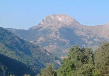
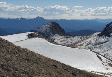
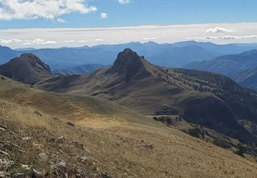
Remontée sur la crête non loin des cloches de Barles et jusqu'au sommet de Chine.
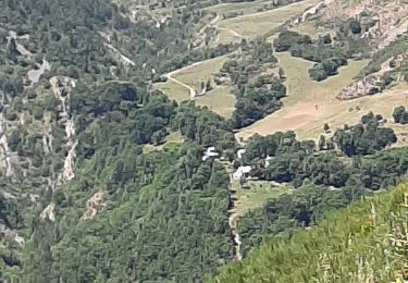
La vallée de Feissal qui vous ramène à Authon, serpente entre les Monges et Géruen. Au carrefour de «Feissal» quittez le GR©6 et restez sur la piste jusqu’à Authon.
Positioning
Comments
Trails nearby
![Trail Walking Barles - BARLES Le Barri AR départ le Bas Moulin o l s - Photo](https://media.geolcdn.com/t/375/260/cc4a106c-cfd4-4655-a8da-47cf56370f9b.jpg&format=jpg&maxdim=2)
![Walking Walking](https://static1.geolcdn.com/sitytour/trail-icons/101.png)
Walking
![](/images/other/stat-length.png)
![](https://static1.geolcdn.com/siteimages/upload/files/16400158638029165_repeat_loop_refresh_sync_direction_icon.png)
![Trail Walking Barles - BARLES Vaux , col de Clapouse , la Laupie. boucle o - Photo](https://media.geolcdn.com/t/375/260/c843e776-1e25-40b9-aafe-ca7db63d170a.jpg&format=jpg&maxdim=2)
![Walking Walking](https://static1.geolcdn.com/sitytour/trail-icons/101.png)
Walking
![](/images/other/stat-length.png)
![](https://static1.geolcdn.com/siteimages/upload/files/16400158638029165_repeat_loop_refresh_sync_direction_icon.png)
![Trail Walking Barles - Cloches de Barles - Photo](https://media.geolcdn.com/t/375/260/ext.jpg?maxdim=2&url=https%3A%2F%2Fstatic1.geolcdn.com%2Fsiteimages%2Fupload%2Ffiles%2F1553511878bg_sport_marche.png)
![Walking Walking](https://static1.geolcdn.com/sitytour/trail-icons/101.png)
Walking
![](/images/other/stat-length.png)
![](https://static1.geolcdn.com/siteimages/upload/files/16400158638029165_repeat_loop_refresh_sync_direction_icon.png)
![Trail Walking Barles - Grande Cloche de Barles - Photo](https://media.geolcdn.com/t/375/260/ext.jpg?maxdim=2&url=https%3A%2F%2Fstatic1.geolcdn.com%2Fsiteimages%2Fupload%2Ffiles%2F1553511878bg_sport_marche.png)
![Walking Walking](https://static1.geolcdn.com/sitytour/trail-icons/101.png)
Walking
![](/images/other/stat-length.png)
![](https://static1.geolcdn.com/siteimages/upload/files/16400158638029165_repeat_loop_refresh_sync_direction_icon.png)
![Trail Walking Auzet - Auzet marzenc 993m 17kms - Photo](https://media.geolcdn.com/t/375/260/9853ba02-1e45-4039-9d76-c79724a3a31a.jpg&format=jpg&maxdim=2)
![Walking Walking](https://static1.geolcdn.com/sitytour/trail-icons/101.png)
Walking
![](/images/other/stat-length.png)
![](https://static1.geolcdn.com/siteimages/upload/files/16400158638029165_repeat_loop_refresh_sync_direction_icon.png)
![Trail Walking Barles - BARLES .TOUR DES CLUES DE VERDACHES O L - Photo](https://media.geolcdn.com/t/375/260/b2aa5727-4b2a-4bb7-ba32-4fb6526da521.jpg&format=jpg&maxdim=2)
![Walking Walking](https://static1.geolcdn.com/sitytour/trail-icons/101.png)
Walking
![](/images/other/stat-length.png)
![](https://static1.geolcdn.com/siteimages/upload/files/16400158638029165_repeat_loop_refresh_sync_direction_icon.png)
![Trail Walking Barles - Chine 14kms 875m - Photo](https://media.geolcdn.com/t/375/260/5461566a-1d2d-4b80-9b71-1def726c1c8f.jpg&format=jpg&maxdim=2)
![Walking Walking](https://static1.geolcdn.com/sitytour/trail-icons/101.png)
Walking
![](/images/other/stat-length.png)
![](https://static1.geolcdn.com/siteimages/upload/files/16400158638029165_repeat_loop_refresh_sync_direction_icon.png)
![Trail Walking Barles - Chine forest - Photo](https://media.geolcdn.com/t/375/260/6f642507-a5eb-4f53-941e-2a762d5a90fc.jpg&format=jpg&maxdim=2)
![Walking Walking](https://static1.geolcdn.com/sitytour/trail-icons/101.png)
Walking
![](/images/other/stat-length.png)
![](https://static1.geolcdn.com/siteimages/upload/files/16400158638029165_repeat_loop_refresh_sync_direction_icon.png)
![Trail Walking Barles - BARLES . LE LAUSS . L ARDOISIERE . O - Photo](https://media.geolcdn.com/t/375/260/9805cbee-b075-42be-849d-cceefdf3fcf7.jpg&format=jpg&maxdim=2)
![Walking Walking](https://static1.geolcdn.com/sitytour/trail-icons/101.png)
Walking
![](/images/other/stat-length.png)
![](https://static1.geolcdn.com/siteimages/upload/files/16400158638029165_repeat_loop_refresh_sync_direction_icon.png)