![](/images/other/stat-length.png)
![Trail Walking Bassens - St Saturnin-Tilleret-18-09-23 - Photo](https://media.geolcdn.com/t/1900/400/ext.pjpeg?maxdim=2&url=https%3A%2F%2Fstatic1.geolcdn.com%2Fsiteimages%2Fupload%2Ffiles%2F1553511878bg_sport_marche.png)
St Saturnin-Tilleret-18-09-23
papou73
User
![Length](/images/other/stat-length.png)
Length
7.3 km
![Max alt](https://static1.geolcdn.com/siteimages/upload/files/1508320355ic_sort_altitude_max_24dp.png)
Max alt
563 m
![Uphill gradient](https://static1.geolcdn.com/siteimages/upload/files/1508320355ic_sort_den_pos_24dp.png)
Uphill gradient
305 m
![Km-Effort](/images/other/stat-length.png)
Km-Effort
11.4 km
![Min alt](https://static1.geolcdn.com/siteimages/upload/files/1508320355ic_sort_altitude_min_24dp.png)
Min alt
317 m
![Downhill gradient](https://static1.geolcdn.com/siteimages/upload/files/1508320355ic_sort_den_neg_24dp.png)
Downhill gradient
306 m
![Boucle](https://static1.geolcdn.com/siteimages/upload/files/16400158638029165_repeat_loop_refresh_sync_direction_icon.png)
Boucle
Yes
Creation date :
2023-09-18 07:29:17.044
Updated on :
2023-09-18 07:36:11.623
![Walking](https://static1.geolcdn.com/sitytour/trail-icons/101.png)
2h35
Difficulty : Medium
![Scan this QR Code to open this trail in the SityTrail application](https://capi.geolives.com/qq0zvz2zws4bq2lad0pu/sitytour/trails/3810172/qr.png?size=200)
FREE GPS app for hiking
About
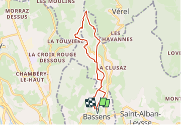
Trail Walking of 7.3 km to be discovered at Auvergne-Rhône-Alpes, Savoy, Bassens. This trail is proposed by papou73.
Description
Au départ du parking Espace colombe (église de Bassens) circuit par la chapelle St Saturnin, le roc Mandrin, le Tilleret, la croix de bon secours, la Clusaz et retour Bassens.
Positioning
Country:
France
Region :
Auvergne-Rhône-Alpes
Department/Province :
Savoy
Municipality :
Bassens
Location:
Unknown
Start:(Dec)
Start:(UTM)
729438 ; 5051844 (31T) N.
Comments
Trails nearby
![Trail Running Saint-Jean-d'Arvey - Tour du plateau de la Leysse - Photo](https://media.geolcdn.com/t/375/260/ext.jpg?maxdim=2&url=https%3A%2F%2Fservices.sitytrail.com%2FGeolivesWS%2FDownloadMedia.ashx%3FTrailID%3D127434%26Media%3D08a8806c-d534-407b-8c02-e91e2473a9c8.JPG)
![Running Running](https://static1.geolcdn.com/sitytour/trail-icons/103.png)
Tour du plateau de la Leysse
Running
Very easy
(1)
Saint-Jean-d'Arvey,
Auvergne-Rhône-Alpes,
Savoy,
France
![](/images/other/stat-length.png)
47 km | 82 km-effort
10h 0min
![](https://static1.geolcdn.com/siteimages/upload/files/16400158638029165_repeat_loop_refresh_sync_direction_icon.png)
Yes
![Trail Walking Challes-les-Eaux - Le Mont Saint-Michel 895 m, depuis Challes-les-Eaux - Photo](https://media.geolcdn.com/t/375/260/ext.jpg?maxdim=2&url=https%3A%2F%2Fservices.sitytrail.com%2FGeolivesWS%2FDownloadMedia.ashx%3FTrailID%3D191627%26Media%3D15268_1.jpg)
![Walking Walking](https://static1.geolcdn.com/sitytour/trail-icons/101.png)
Le Mont Saint-Michel 895 m, depuis Challes-les-Eaux
Walking
Difficult
(1)
Challes-les-Eaux,
Auvergne-Rhône-Alpes,
Savoy,
France
![](/images/other/stat-length.png)
7.6 km | 15 km-effort
4h 15min
![](https://static1.geolcdn.com/siteimages/upload/files/16400158638029165_repeat_loop_refresh_sync_direction_icon.png)
Yes
![Trail Mountain bike Bassens - Pragondra - Photo](https://media.geolcdn.com/t/375/260/ext.jpg?maxdim=2&url=https%3A%2F%2Fservices.sitytrail.com%2FGeolivesWS%2FDownloadMedia.ashx%3FTrailID%3D147927%26Media%3D20120818110710.jpg)
![Mountain bike Mountain bike](https://static1.geolcdn.com/sitytour/trail-icons/202.png)
Pragondra
Mountain bike
Very easy
(1)
Bassens,
Auvergne-Rhône-Alpes,
Savoy,
France
![](/images/other/stat-length.png)
24 km | 34 km-effort
2h 49min
![](https://static1.geolcdn.com/siteimages/upload/files/16400158638029165_repeat_loop_refresh_sync_direction_icon.png)
No
![Trail Mountain bike Cognin - Autour du Corbeley - Photo](https://media.geolcdn.com/t/375/260/ext.jpg?maxdim=2&url=https%3A%2F%2Fstatic1.geolcdn.com%2Fsiteimages%2Fupload%2Ffiles%2F1524743154velo.jpg)
![Mountain bike Mountain bike](https://static1.geolcdn.com/sitytour/trail-icons/202.png)
Autour du Corbeley
Mountain bike
Medium
(1)
Cognin,
Auvergne-Rhône-Alpes,
Savoy,
France
![](/images/other/stat-length.png)
25 km | 38 km-effort
2h 23min
![](https://static1.geolcdn.com/siteimages/upload/files/16400158638029165_repeat_loop_refresh_sync_direction_icon.png)
Yes
![Trail Walking Saint-Alban-Leysse - 73- Le chemin des poussettes - Photo](https://media.geolcdn.com/t/375/260/ext.jpg?maxdim=2&url=https%3A%2F%2Fstatic1.geolcdn.com%2Fsiteimages%2Fupload%2Ffiles%2F1553511878bg_sport_marche.png)
![Walking Walking](https://static1.geolcdn.com/sitytour/trail-icons/101.png)
73- Le chemin des poussettes
Walking
Easy
(1)
Saint-Alban-Leysse,
Auvergne-Rhône-Alpes,
Savoy,
France
![](/images/other/stat-length.png)
4.9 km | 10.6 km-effort
2h 2min
![](https://static1.geolcdn.com/siteimages/upload/files/16400158638029165_repeat_loop_refresh_sync_direction_icon.png)
Yes
![Trail Mountain bike Saint-Alban-Leysse - 2012-03-24 - Malpassant+ St sat - Photo](https://media.geolcdn.com/t/375/260/ext.jpg?maxdim=2&url=https%3A%2F%2Fstatic1.geolcdn.com%2Fsiteimages%2Fupload%2Ffiles%2F1524743154velo.jpg)
![Mountain bike Mountain bike](https://static1.geolcdn.com/sitytour/trail-icons/202.png)
2012-03-24 - Malpassant+ St sat
Mountain bike
Medium
(1)
Saint-Alban-Leysse,
Auvergne-Rhône-Alpes,
Savoy,
France
![](/images/other/stat-length.png)
27 km | 44 km-effort
3h 2min
![](https://static1.geolcdn.com/siteimages/upload/files/16400158638029165_repeat_loop_refresh_sync_direction_icon.png)
Yes
![Trail Walking Les Déserts - Nivolet - Photo](https://media.geolcdn.com/t/375/260/048cf6ab-404d-4bce-bd74-e2c4ccef4fd8.jpg&format=jpg&maxdim=2)
![Walking Walking](https://static1.geolcdn.com/sitytour/trail-icons/101.png)
Nivolet
Walking
Medium
Les Déserts,
Auvergne-Rhône-Alpes,
Savoy,
France
![](/images/other/stat-length.png)
8.5 km | 19 km-effort
5h 29min
![](https://static1.geolcdn.com/siteimages/upload/files/16400158638029165_repeat_loop_refresh_sync_direction_icon.png)
Yes
![Trail Hybrid bike Cognin - Chambéry jujurieux - Photo](https://media.geolcdn.com/t/375/260/718fb78c-ba3a-4f4f-9193-923a356e563d.jpg&format=jpg&maxdim=2)
![Hybrid bike Hybrid bike](https://static1.geolcdn.com/sitytour/trail-icons/203.png)
Chambéry jujurieux
Hybrid bike
Difficult
Cognin,
Auvergne-Rhône-Alpes,
Savoy,
France
![](/images/other/stat-length.png)
123 km | 143 km-effort
7h 30min
![](https://static1.geolcdn.com/siteimages/upload/files/16400158638029165_repeat_loop_refresh_sync_direction_icon.png)
No
![Trail Walking Les Déserts - CROIX DU NIVOLET depuis maison brûlée - Photo](https://media.geolcdn.com/t/375/260/91c62f02-6ade-47f8-b1f4-e1f1b7b238a1.jpg&format=jpg&maxdim=2)
![Walking Walking](https://static1.geolcdn.com/sitytour/trail-icons/101.png)
CROIX DU NIVOLET depuis maison brûlée
Walking
Difficult
Les Déserts,
Auvergne-Rhône-Alpes,
Savoy,
France
![](/images/other/stat-length.png)
11.1 km | 23 km-effort
7h 42min
![](https://static1.geolcdn.com/siteimages/upload/files/16400158638029165_repeat_loop_refresh_sync_direction_icon.png)
Yes