![](/images/other/stat-length.png)
Liaison VTT1-VTT3
Maison du Tourisme Explore Meuse
Vivez Explore Meuse GUIDE+
![Length](/images/other/stat-length.png)
Length
1.6 km
![Max alt](https://static1.geolcdn.com/siteimages/upload/files/1508320355ic_sort_altitude_max_24dp.png)
Max alt
284 m
![Uphill gradient](https://static1.geolcdn.com/siteimages/upload/files/1508320355ic_sort_den_pos_24dp.png)
Uphill gradient
6 m
![Km-Effort](/images/other/stat-length.png)
Km-Effort
1.7 km
![Min alt](https://static1.geolcdn.com/siteimages/upload/files/1508320355ic_sort_altitude_min_24dp.png)
Min alt
266 m
![Downhill gradient](https://static1.geolcdn.com/siteimages/upload/files/1508320355ic_sort_den_neg_24dp.png)
Downhill gradient
21 m
![Boucle](https://static1.geolcdn.com/siteimages/upload/files/16400158638029165_repeat_loop_refresh_sync_direction_icon.png)
Boucle
No
![Signpost](https://services.sitytrail.com/GeolivesWS/DownloadMedia.ashx?TrailID=380907&Media=balise.png)
Signpost
Creation date :
2017-11-17 00:00:00.0
Updated on :
2017-11-17 00:00:00.0
![Mountain bike](https://static1.geolcdn.com/sitytour/trail-icons/202.png)
6m
Difficulty : Easy
![Scan this QR Code to open this trail in the SityTrail application](https://capi.geolives.com/qq0zvz2zws4bq2lad0pu/sitytour/trails/380907/qr.png?size=200)
FREE GPS app for hiking
About
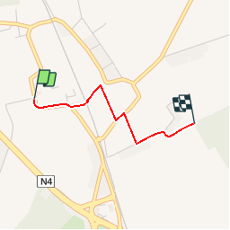
Trail Mountain bike of 1.6 km to be discovered at Wallonia, Namur, Assesse. This trail is proposed by Maison du Tourisme Explore Meuse.
Description
Cette liaison permet de joindre le circuit VTT1 et le circuit VTT3, afin d'allonger le parcours si on le souhaite.
Points of interest
Positioning
Country:
Belgium
Region :
Wallonia
Department/Province :
Namur
Municipality :
Assesse
Location:
Courrière
Start:(Dec)
Start:(UTM)
641320 ; 5584226 (31U) N.
Comments
Trails nearby
![Trail Walking Assesse - RB-Na-02 Raccourci - Les collines de la vallée du Bocq - Photo](https://media.geolcdn.com/t/375/260/ext.jpg?maxdim=2&url=https%3A%2F%2Fservices.sitytrail.com%2FGeolivesWS%2FDownloadMedia.ashx%3FTrailID%3D794014%26Media%3Dc4c97e29-7bfb-495c-ae56-13528ce8d0b3.JPG)
![Walking Walking](https://static1.geolcdn.com/sitytour/trail-icons/101.png)
RB-Na-02 Raccourci - Les collines de la vallée du Bocq
Walking
Medium
(7)
Assesse,
Wallonia,
Namur,
Belgium
![](/images/other/stat-length.png)
17 km | 23 km-effort
5h 32min
![](https://static1.geolcdn.com/siteimages/upload/files/16400158638029165_repeat_loop_refresh_sync_direction_icon.png)
Yes
![Trail Walking Assesse - RB-Na-02 Les collines de la vallée du Bocq - Photo](https://media.geolcdn.com/t/375/260/ext.jpg?maxdim=2&url=https%3A%2F%2Fservices.sitytrail.com%2FGeolivesWS%2FDownloadMedia.ashx%3FTrailID%3D250531%26Media%3Dc4c97e29-7bfb-495c-ae56-13528ce8d0b3.JPG)
![Walking Walking](https://static1.geolcdn.com/sitytour/trail-icons/101.png)
RB-Na-02 Les collines de la vallée du Bocq
Walking
Medium
(21)
Assesse,
Wallonia,
Namur,
Belgium
![](/images/other/stat-length.png)
21 km | 28 km-effort
5h 32min
![](https://static1.geolcdn.com/siteimages/upload/files/16400158638029165_repeat_loop_refresh_sync_direction_icon.png)
Yes
![Trail Walking Gesves - RB-Na-01 Raccourci - Vallée du Samson en Condroz namurois - Photo](https://media.geolcdn.com/t/375/260/ext.jpg?maxdim=2&url=https%3A%2F%2Fservices.sitytrail.com%2FGeolivesWS%2FDownloadMedia.ashx%3FTrailID%3D213609%26Media%3D506f23b2-0581-4f03-b006-9ca575596278.jpg)
![Walking Walking](https://static1.geolcdn.com/sitytour/trail-icons/101.png)
RB-Na-01 Raccourci - Vallée du Samson en Condroz namurois
Walking
Very difficult
(15)
Gesves,
Wallonia,
Namur,
Belgium
![](/images/other/stat-length.png)
18.3 km | 25 km-effort
5h 34min
![](https://static1.geolcdn.com/siteimages/upload/files/16400158638029165_repeat_loop_refresh_sync_direction_icon.png)
Yes
![Trail Walking Gesves - RB-Na-01 Vallée du Samson en Condroz namurois - Photo](https://media.geolcdn.com/t/375/260/ext.jpg?maxdim=2&url=https%3A%2F%2Fservices.sitytrail.com%2FGeolivesWS%2FDownloadMedia.ashx%3FTrailID%3D179626%26Media%3D506f23b2-0581-4f03-b006-9ca575596278.jpg)
![Walking Walking](https://static1.geolcdn.com/sitytour/trail-icons/101.png)
RB-Na-01 Vallée du Samson en Condroz namurois
Walking
Very difficult
(15)
Gesves,
Wallonia,
Namur,
Belgium
![](/images/other/stat-length.png)
25 km | 33 km-effort
7h 26min
![](https://static1.geolcdn.com/siteimages/upload/files/16400158638029165_repeat_loop_refresh_sync_direction_icon.png)
Yes
![Trail Walking Gesves - GESVES- Le Pré D'Amite- N°07- Bois - Photo](https://media.geolcdn.com/t/375/260/ext.jpg?maxdim=2&url=https%3A%2F%2Fservices.sitytrail.com%2FGeolivesWS%2FDownloadMedia.ashx%3FTrailID%3D121401%26Media%3D56c27e3a-fec1-4804-be43-ac45373f04b7.jpg)
![Walking Walking](https://static1.geolcdn.com/sitytour/trail-icons/101.png)
GESVES- Le Pré D'Amite- N°07- Bois
Walking
Difficult
(13)
Gesves,
Wallonia,
Namur,
Belgium
![](/images/other/stat-length.png)
9.4 km | 12.5 km-effort
2h 41min
![](https://static1.geolcdn.com/siteimages/upload/files/16400158638029165_repeat_loop_refresh_sync_direction_icon.png)
Yes
![Trail Walking Assesse - 05 Paysage condruzien - Photo](https://media.geolcdn.com/t/375/260/ext.jpg?maxdim=2&url=https%3A%2F%2Fservices.sitytrail.com%2FGeolivesWS%2FDownloadMedia.ashx%3FTrailID%3D121392%26Media%3D31d83d0c-5bcd-44cd-b8d6-1cc6a3d25bf9.jpg)
![Walking Walking](https://static1.geolcdn.com/sitytour/trail-icons/101.png)
05 Paysage condruzien
Walking
Easy
(5)
Assesse,
Wallonia,
Namur,
Belgium
![](/images/other/stat-length.png)
10.2 km | 13.3 km-effort
2h 11min
![](https://static1.geolcdn.com/siteimages/upload/files/16400158638029165_repeat_loop_refresh_sync_direction_icon.png)
No
![Trail Walking Namur - De Naninne vers Dave par les Fonds de Lustin et les Bois d'Acremont - Photo](https://media.geolcdn.com/t/375/260/ext.jpg?maxdim=2&url=https%3A%2F%2Fstatic1.geolcdn.com%2Fsiteimages%2Fupload%2Ffiles%2F1553511878bg_sport_marche.png)
![Walking Walking](https://static1.geolcdn.com/sitytour/trail-icons/101.png)
De Naninne vers Dave par les Fonds de Lustin et les Bois d'Acremont
Walking
Medium
(5)
Namur,
Wallonia,
Namur,
Belgium
![](/images/other/stat-length.png)
19 km | 25 km-effort
5h 0min
![](https://static1.geolcdn.com/siteimages/upload/files/16400158638029165_repeat_loop_refresh_sync_direction_icon.png)
Yes
![Trail Walking Assesse - GG-Na-18_Sart-Bernard - Andenne - Photo](https://media.geolcdn.com/t/375/260/ee170bcd-2fb4-4927-aeb6-2a32aed3e834.jpg&format=jpg&maxdim=2)
![Walking Walking](https://static1.geolcdn.com/sitytour/trail-icons/101.png)
GG-Na-18_Sart-Bernard - Andenne
Walking
Very difficult
(1)
Assesse,
Wallonia,
Namur,
Belgium
![](/images/other/stat-length.png)
25 km | 32 km-effort
6h 49min
![](https://static1.geolcdn.com/siteimages/upload/files/16400158638029165_repeat_loop_refresh_sync_direction_icon.png)
No
![Trail Walking Assesse - Promenade à Crupet - Photo](https://media.geolcdn.com/t/375/260/ext.jpg?maxdim=2&url=https%3A%2F%2Fservices.sitytrail.com%2FGeolivesWS%2FDownloadMedia.ashx%3FTrailID%3D532928%26Media%3De78ba70e-0d4d-4d8c-b509-37ad32b8d33e.jpg)
![Walking Walking](https://static1.geolcdn.com/sitytour/trail-icons/101.png)
Promenade à Crupet
Walking
Easy
(3)
Assesse,
Wallonia,
Namur,
Belgium
![](/images/other/stat-length.png)
8.3 km | 11.4 km-effort
2h 30min
![](https://static1.geolcdn.com/siteimages/upload/files/16400158638029165_repeat_loop_refresh_sync_direction_icon.png)
Yes