![](/images/other/stat-length.png)
![Trail Walking Lennik - gaasbeek (départ du parking du château) - Photo](https://media.geolcdn.com/t/1900/400/b65667a1-6a17-4664-a23a-2140eac1eacf.jpg&format=pjpeg&maxdim=2)
gaasbeek (départ du parking du château)
ELISECRO
User
![Length](/images/other/stat-length.png)
Length
7.2 km
![Max alt](https://static1.geolcdn.com/siteimages/upload/files/1508320355ic_sort_altitude_max_24dp.png)
Max alt
88 m
![Uphill gradient](https://static1.geolcdn.com/siteimages/upload/files/1508320355ic_sort_den_pos_24dp.png)
Uphill gradient
103 m
![Km-Effort](/images/other/stat-length.png)
Km-Effort
8.6 km
![Min alt](https://static1.geolcdn.com/siteimages/upload/files/1508320355ic_sort_altitude_min_24dp.png)
Min alt
31 m
![Downhill gradient](https://static1.geolcdn.com/siteimages/upload/files/1508320355ic_sort_den_neg_24dp.png)
Downhill gradient
111 m
![Boucle](https://static1.geolcdn.com/siteimages/upload/files/16400158638029165_repeat_loop_refresh_sync_direction_icon.png)
Boucle
No
Creation date :
2023-09-14 08:17:30.894
Updated on :
2024-05-13 14:06:29.209
![Walking](https://static1.geolcdn.com/sitytour/trail-icons/101.png)
1h57
Difficulty : Medium
![Scan this QR Code to open this trail in the SityTrail application](https://capi.geolives.com/qq0zvz2zws4bq2lad0pu/sitytour/trails/3805904/qr.png?size=200)
FREE GPS app for hiking
About
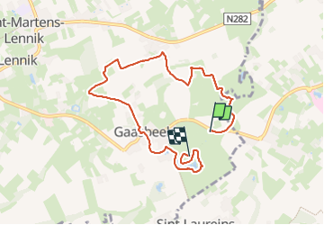
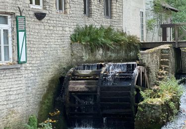
Trail Walking of 7.2 km to be discovered at Flanders, Flemish Brabant, Lennik. This trail is proposed by ELISECRO.
Description
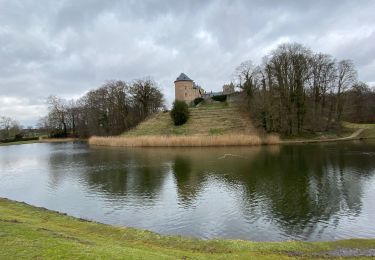
promenade dans le domaine du château du GROENENBERG et ensuite sentiers et petits chemins dans le pajottenland; retour par le domaine du château de GAASBEEK (parcours complet à l'arrière de celui-ci par les étangs , le ruisseau et les bois et remontée vers le château)
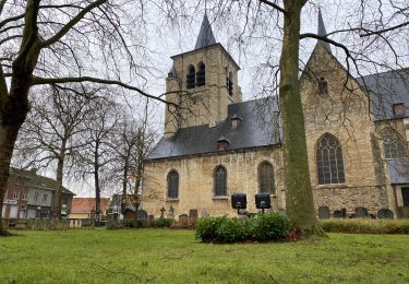
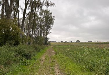
Positioning
Country:
Belgium
Region :
Flanders
Department/Province :
Flemish Brabant
Municipality :
Lennik
Location:
Gaasbeek
Start:(Dec)
Start:(UTM)
584684 ; 5628257 (31U) N.
Comments
Trails nearby
![Trail Walking Lennik - Autour de Gaasbeek - Photo](https://media.geolcdn.com/t/375/260/5c335b1b-d34f-4c3a-9430-6e6f640c8bc4.jpg&format=jpg&maxdim=2)
![Walking Walking](https://static1.geolcdn.com/sitytour/trail-icons/101.png)
Autour de Gaasbeek
Walking
Easy
(1)
Lennik,
Flanders,
Flemish Brabant,
Belgium
![](/images/other/stat-length.png)
9.1 km | 10.9 km-effort
2h 10min
![](https://static1.geolcdn.com/siteimages/upload/files/16400158638029165_repeat_loop_refresh_sync_direction_icon.png)
Yes
![Trail Walking Sint-Pieters-Leeuw - pajottenland_0521 - Photo](https://media.geolcdn.com/t/375/260/ext.jpg?maxdim=2&url=https%3A%2F%2Fstatic1.geolcdn.com%2Fsiteimages%2Fupload%2Ffiles%2F1553511878bg_sport_marche.png)
![Walking Walking](https://static1.geolcdn.com/sitytour/trail-icons/101.png)
pajottenland_0521
Walking
Medium
(1)
Sint-Pieters-Leeuw,
Flanders,
Flemish Brabant,
Belgium
![](/images/other/stat-length.png)
8.7 km | 9.7 km-effort
2h 14min
![](https://static1.geolcdn.com/siteimages/upload/files/16400158638029165_repeat_loop_refresh_sync_direction_icon.png)
Yes
![Trail Walking Sint-Pieters-Leeuw - Leeuw Saint Pierre 21,6 km - Photo](https://media.geolcdn.com/t/375/260/d1761a3a-5d29-4e75-930e-e4d45b33cda9.jpg&format=jpg&maxdim=2)
![Walking Walking](https://static1.geolcdn.com/sitytour/trail-icons/101.png)
Leeuw Saint Pierre 21,6 km
Walking
Easy
Sint-Pieters-Leeuw,
Flanders,
Flemish Brabant,
Belgium
![](/images/other/stat-length.png)
22 km | 25 km-effort
5h 49min
![](https://static1.geolcdn.com/siteimages/upload/files/16400158638029165_repeat_loop_refresh_sync_direction_icon.png)
Yes
![Trail Walking Lennik - Gaasbeeck matin - Photo](https://media.geolcdn.com/t/375/260/ext.jpg?maxdim=2&url=https%3A%2F%2Fstatic1.geolcdn.com%2Fsiteimages%2Fupload%2Ffiles%2F1553511878bg_sport_marche.png)
![Walking Walking](https://static1.geolcdn.com/sitytour/trail-icons/101.png)
Gaasbeeck matin
Walking
Very easy
(3)
Lennik,
Flanders,
Flemish Brabant,
Belgium
![](/images/other/stat-length.png)
9.4 km | 10.8 km-effort
2h 34min
![](https://static1.geolcdn.com/siteimages/upload/files/16400158638029165_repeat_loop_refresh_sync_direction_icon.png)
Yes
![Trail On foot Anderlecht - Bruegel route (du resto den Appelboom) - Photo](https://media.geolcdn.com/t/375/260/ext.jpg?maxdim=2&url=https%3A%2F%2Fstatic1.geolcdn.com%2Fsiteimages%2Fupload%2Ffiles%2F1545311037marcheuse_200dpi.jpg)
![On foot On foot](https://static1.geolcdn.com/sitytour/trail-icons/100.png)
Bruegel route (du resto den Appelboom)
On foot
Easy
(1)
Anderlecht,
Brussels-Capital,
Unknown,
Belgium
![](/images/other/stat-length.png)
8.2 km | 9.7 km-effort
Unknown
![](https://static1.geolcdn.com/siteimages/upload/files/16400158638029165_repeat_loop_refresh_sync_direction_icon.png)
Yes
![Trail Walking Lennik - schepdaal 14 km - Photo](https://media.geolcdn.com/t/375/260/ext.jpg?maxdim=2&url=https%3A%2F%2Fstatic1.geolcdn.com%2Fsiteimages%2Fupload%2Ffiles%2F1553511878bg_sport_marche.png)
![Walking Walking](https://static1.geolcdn.com/sitytour/trail-icons/101.png)
schepdaal 14 km
Walking
Very easy
(1)
Lennik,
Flanders,
Flemish Brabant,
Belgium
![](/images/other/stat-length.png)
14.2 km | 16.9 km-effort
2h 58min
![](https://static1.geolcdn.com/siteimages/upload/files/16400158638029165_repeat_loop_refresh_sync_direction_icon.png)
Yes
![Trail Walking Lennik - Sint Martens Lennik 7,9 km - Photo](https://media.geolcdn.com/t/375/260/1ff1b843-1bd4-4c35-9997-d2a88eb92555.jpg&format=jpg&maxdim=2)
![Walking Walking](https://static1.geolcdn.com/sitytour/trail-icons/101.png)
Sint Martens Lennik 7,9 km
Walking
Easy
Lennik,
Flanders,
Flemish Brabant,
Belgium
![](/images/other/stat-length.png)
7.9 km | 8.8 km-effort
1h 59min
![](https://static1.geolcdn.com/siteimages/upload/files/16400158638029165_repeat_loop_refresh_sync_direction_icon.png)
Yes
![Trail Road bike Sint-Pieters-Leeuw - La promenade verte autour de Bruxelles - Photo](https://media.geolcdn.com/t/375/260/6ea46bbe-3105-4327-905a-f71e3260e1e4.jpg&format=jpg&maxdim=2)
![Road bike Road bike](https://static1.geolcdn.com/sitytour/trail-icons/201.png)
La promenade verte autour de Bruxelles
Road bike
Medium
Sint-Pieters-Leeuw,
Flanders,
Flemish Brabant,
Belgium
![](/images/other/stat-length.png)
65 km | 75 km-effort
9h 57min
![](https://static1.geolcdn.com/siteimages/upload/files/16400158638029165_repeat_loop_refresh_sync_direction_icon.png)
Yes
![Trail Walking Dilbeek - Sint Anna Pede petit tour - Photo](https://media.geolcdn.com/t/375/260/21da7e7d-422b-4f67-9990-46a447269bd4.jpg&format=jpg&maxdim=2)
![Walking Walking](https://static1.geolcdn.com/sitytour/trail-icons/101.png)
Sint Anna Pede petit tour
Walking
Very easy
Dilbeek,
Flanders,
Flemish Brabant,
Belgium
![](/images/other/stat-length.png)
7.5 km | 8.1 km-effort
2h 9min
![](https://static1.geolcdn.com/siteimages/upload/files/16400158638029165_repeat_loop_refresh_sync_direction_icon.png)
Yes