![](/images/other/stat-length.png)
![Trail Walking Baztan - De Gorramendi à Akomendi et Irubel kaskoaa - Photo](https://media.geolcdn.com/t/1900/400/ext.pjpeg?maxdim=2&url=https%3A%2F%2Fstatic1.geolcdn.com%2Fsiteimages%2Fupload%2Ffiles%2F1553511878bg_sport_marche.png)
De Gorramendi à Akomendi et Irubel kaskoaa
DECHAMPD
User
![Length](/images/other/stat-length.png)
Length
13.9 km
![Max alt](https://static1.geolcdn.com/siteimages/upload/files/1508320355ic_sort_altitude_max_24dp.png)
Max alt
1083 m
![Uphill gradient](https://static1.geolcdn.com/siteimages/upload/files/1508320355ic_sort_den_pos_24dp.png)
Uphill gradient
807 m
![Km-Effort](/images/other/stat-length.png)
Km-Effort
25 km
![Min alt](https://static1.geolcdn.com/siteimages/upload/files/1508320355ic_sort_altitude_min_24dp.png)
Min alt
694 m
![Downhill gradient](https://static1.geolcdn.com/siteimages/upload/files/1508320355ic_sort_den_neg_24dp.png)
Downhill gradient
808 m
![Boucle](https://static1.geolcdn.com/siteimages/upload/files/16400158638029165_repeat_loop_refresh_sync_direction_icon.png)
Boucle
Yes
Creation date :
2019-01-14 17:34:41.811
Updated on :
2019-01-14 17:34:41.848
![Walking](https://static1.geolcdn.com/sitytour/trail-icons/101.png)
4h58
Difficulty : Medium
![Scan this QR Code to open this trail in the SityTrail application](https://capi.geolives.com/qq0zvz2zws4bq2lad0pu/sitytour/trails/380427/qr.png?size=200)
FREE GPS app for hiking
About
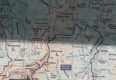
Trail Walking of 13.9 km to be discovered at Navarre, Unknown, Baztan. This trail is proposed by DECHAMPD.
Description
Balade hivernale et sans difficulté le long des crêtes, en "pays" de Baztan.
en direction de l'ensemble Gorramendi-Otanarte-Gorramakil, depuis le col Itzulegi / Itzulegiko lepoa. Ce massif est le premier des Pyrénées situé au-dessus de 1000m, en venant de l'Océan Atlantique.
Positioning
Country:
Spain
Region :
Navarre
Department/Province :
Unknown
Municipality :
Baztan
Location:
Unknown
Start:(Dec)
Start:(UTM)
625600 ; 4786026 (30T) N.
Comments
Trails nearby
![Trail On foot Saint-Étienne-de-Baïgorry - SL-NA Elorrieta - Photo](https://media.geolcdn.com/t/375/260/69fa3b6a-5100-4dfb-99ea-46b44a00f11d.jpeg&format=jpg&maxdim=2)
![On foot On foot](https://static1.geolcdn.com/sitytour/trail-icons/100.png)
SL-NA Elorrieta
On foot
Easy
Saint-Étienne-de-Baïgorry,
New Aquitaine,
Pyrénées-Atlantiques,
France
![](/images/other/stat-length.png)
5.8 km | 10 km-effort
2h 15min
![](https://static1.geolcdn.com/siteimages/upload/files/16400158638029165_repeat_loop_refresh_sync_direction_icon.png)
Yes
![Trail Walking Baztan - MAILARRETA OTSONDO Frontières en béton dans le massif du Gorramendi 300m. - Photo](https://media.geolcdn.com/t/375/260/8b1035fc-8a50-4048-9924-4944066be27d.jpg&format=jpg&maxdim=2)
![Walking Walking](https://static1.geolcdn.com/sitytour/trail-icons/101.png)
MAILARRETA OTSONDO Frontières en béton dans le massif du Gorramendi 300m.
Walking
Difficult
Baztan,
Navarre,
Unknown,
Spain
![](/images/other/stat-length.png)
8.5 km | 12.5 km-effort
2h 50min
![](https://static1.geolcdn.com/siteimages/upload/files/16400158638029165_repeat_loop_refresh_sync_direction_icon.png)
Yes
![Trail Walking Baztan - MAILARRETA OTSONDO Frontières en béton dans le massif du Gorramendi - Photo](https://media.geolcdn.com/t/375/260/ext.jpg?maxdim=2&url=https%3A%2F%2Fservices.sitytrail.com%2FGeolivesWS%2FDownloadMedia.ashx%3FTrailID%3D526426%26Media%3Dfix__20160208095835.jpg)
![Walking Walking](https://static1.geolcdn.com/sitytour/trail-icons/101.png)
MAILARRETA OTSONDO Frontières en béton dans le massif du Gorramendi
Walking
Difficult
Baztan,
Navarre,
Unknown,
Spain
![](/images/other/stat-length.png)
10 km | 15.3 km-effort
3h 29min
![](https://static1.geolcdn.com/siteimages/upload/files/16400158638029165_repeat_loop_refresh_sync_direction_icon.png)
Yes
![Trail On foot Baztan - SL-NA Alkurruntz - Photo](https://media.geolcdn.com/t/375/260/52f4bcee-e0a0-4b91-9588-fad8a39e9c22.jpeg&format=jpg&maxdim=2)
![On foot On foot](https://static1.geolcdn.com/sitytour/trail-icons/100.png)
![Trail Walking Saint-Étienne-de-Baïgorry - 20210520 tour depuis Izpegi - Photo](https://media.geolcdn.com/t/375/260/e95b452d-8dd6-4fd8-a386-b8e9176ca32d.jpg&format=jpg&maxdim=2)
![Walking Walking](https://static1.geolcdn.com/sitytour/trail-icons/101.png)
20210520 tour depuis Izpegi
Walking
Easy
Saint-Étienne-de-Baïgorry,
New Aquitaine,
Pyrénées-Atlantiques,
France
![](/images/other/stat-length.png)
8.6 km | 14.7 km-effort
2h 59min
![](https://static1.geolcdn.com/siteimages/upload/files/16400158638029165_repeat_loop_refresh_sync_direction_icon.png)
Yes
![Trail Walking Baztan - ALKURRUNTZ depuis le parling de Lizarmeak - Photo](https://media.geolcdn.com/t/375/260/8e46e580-3773-4095-8da1-5fb11edfdedc.jpg&format=jpg&maxdim=2)
![Walking Walking](https://static1.geolcdn.com/sitytour/trail-icons/101.png)
ALKURRUNTZ depuis le parling de Lizarmeak
Walking
Easy
(1)
Baztan,
Navarre,
Unknown,
Spain
![](/images/other/stat-length.png)
8.6 km | 13.8 km-effort
2h 52min
![](https://static1.geolcdn.com/siteimages/upload/files/16400158638029165_repeat_loop_refresh_sync_direction_icon.png)
No
![Trail Walking Baztan - Meatzetako Bizkarra depuis le col d'Urrizti (proche d'Otsondo) - Photo](https://media.geolcdn.com/t/375/260/ext.jpg?maxdim=2&url=https%3A%2F%2Fservices.sitytrail.com%2FGeolivesWS%2FDownloadMedia.ashx%3FTrailID%3D526426%26Media%3Dfix__20160208095835.jpg)
![Walking Walking](https://static1.geolcdn.com/sitytour/trail-icons/101.png)
Meatzetako Bizkarra depuis le col d'Urrizti (proche d'Otsondo)
Walking
Difficult
Baztan,
Navarre,
Unknown,
Spain
![](/images/other/stat-length.png)
9.7 km | 15.2 km-effort
3h 26min
![](https://static1.geolcdn.com/siteimages/upload/files/16400158638029165_repeat_loop_refresh_sync_direction_icon.png)
Yes
![Trail Walking Baztan - Baztan vallée Aritzakun PR NA 6 - Photo](https://media.geolcdn.com/t/375/260/ext.jpg?maxdim=2&url=https%3A%2F%2Fservices.sitytrail.com%2FGeolivesWS%2FDownloadMedia.ashx%3FTrailID%3D402986%26Media%3Dfix__20150402155929.jpg)
![Walking Walking](https://static1.geolcdn.com/sitytour/trail-icons/101.png)
Baztan vallée Aritzakun PR NA 6
Walking
Very difficult
(2)
Baztan,
Navarre,
Unknown,
Spain
![](/images/other/stat-length.png)
14.2 km | 22 km-effort
5h 6min
![](https://static1.geolcdn.com/siteimages/upload/files/16400158638029165_repeat_loop_refresh_sync_direction_icon.png)
Yes
![Trail Walking Baztan - Alkunrrutz 2024/07/09 - Photo](https://media.geolcdn.com/t/375/260/0036da28-2f1e-4d27-b8ed-481df7747bc4.jpg&format=jpg&maxdim=2)
![Walking Walking](https://static1.geolcdn.com/sitytour/trail-icons/101.png)
Alkunrrutz 2024/07/09
Walking
Medium
Baztan,
Navarre,
Unknown,
Spain
![](/images/other/stat-length.png)
8.2 km | 11.7 km-effort
2h 39min
![](https://static1.geolcdn.com/siteimages/upload/files/16400158638029165_repeat_loop_refresh_sync_direction_icon.png)
No