Trail Walking Mont-Albert - Mont Albert - Photo
 aldaus
aldaus

User

© OpenStreetMap contributors
Length
Length
13.5 km
Max alt
Max alt
1061 m
Uphill gradient
Uphill gradient
880 m
Km-Effort
Km-Effort  
25 km
Min alt
Min alt
207 m
Downhill gradient
Downhill gradient
879 m
Boucle
Boucle
Yes
Creation date :
2023-09-08 10:47:08.352
Updated on :
2023-09-08 20:46:46.442

(0 Reviews)

Walking
Walking
3h43
Difficulty : Medium

Scan this QR Code to open this trail in the SityTrail application

FREE GPS app for hiking

Logo SityTrail SityTrail

IGN / Geographical institutes

Download SityTrail from the App Store Download SityTrail from Google Play

Logo SityTrail SityTrail World

The world is yours!

Download SityTrail from the App Store Download SityTrail from Google Play Download SityTrail on Huawei AppGallery

About

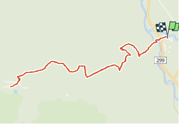
Trail Walking of 13.5 km to be discovered at Quebec, La Haute-Gaspésie, Mont-Albert. This trail is proposed by aldaus.

Description

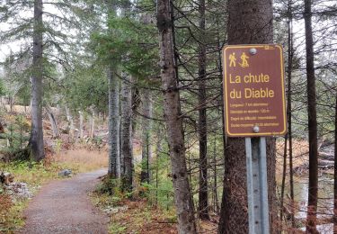
pour nous alpin...c est une rando sympa en moyenne montagne mais nous sommes au Québec à 1000 m alors tout change

Elevation profile

Positioning

Country:
Canada
Region :
Quebec
Department/Province :
La Haute-Gaspésie
Municipality :
Mont-Albert
Location:
Unknown
Start:(UTM)
710764 ; 5425555 (19U) N.

Trails nearby

Trail Walking Mont-Albert - 2014-08-10 18:36:31 - Photo
Walking
GUIDE
Alizée.pee

Walking

Easy
(1)
Mont-Albert, Quebec, La Haute-Gaspésie, Canada
4.5 km | 7 km-effort
1h 50min
Yes
Trail Walking Mont-Albert - Chutes du diable - sentier du Mont Albert - Photo
Walking
ajpbm

Walking

Medium
Mont-Albert, Quebec, La Haute-Gaspésie, Canada
6.9 km | 8.6 km-effort
1h 48min
Yes
Trail Walking Mont-Albert - 2014-08-11 15:45:09 - Photo
Walking
GUIDE
Alizée.pee

Walking

Very difficult
Mont-Albert, Quebec, La Haute-Gaspésie, Canada
16.8 km | 29 km-effort
7h 0min
Yes
Trail Walking Mont-Albert - Wikiloc - Mont Olivine et Abri de la Serpentine - Photo
Walking
GUIDE
Alizée.pee

Walking

Very difficult
Mont-Albert, Quebec, La Haute-Gaspésie, Canada
17 km | 26 km-effort
5h 19min
Yes
Trail Walking Mont-Albert - Wikiloc - Chute du diable - Photo
Walking
GUIDE
Alizée.pee

Walking

Medium
Mont-Albert, Quebec, La Haute-Gaspésie, Canada
7.1 km | 9.1 km-effort
1h 56min
Yes
Trail Walking Mont-Albert - Wikiloc - Parc National de la Gaspésie - Mont Ernest Laforce - Photo
Walking
GUIDE
Alizée.pee

Walking

Medium
Mont-Albert, Quebec, La Haute-Gaspésie, Canada
5.5 km | 8.6 km-effort
1h 46min
Yes
Trail Walking Mont-Albert - Wikiloc - Parc National de la Gaspesie. Tour du Mont Albert - Photo
Walking
GUIDE
Alizée.pee

Walking

Very difficult
Mont-Albert, Quebec, La Haute-Gaspésie, Canada
17 km | 29 km-effort
5h 53min
Yes
Trail Walking Mont-Albert - Tour du mont Ernest Laforce - Photo
Walking
s0c7

Walking

Very easy
Mont-Albert, Quebec, La Haute-Gaspésie, Canada
7.8 km | 11.1 km-effort
1h 15min
No
Trail Walking Mont-Albert - mont Ernest Laforce  - Photo
Walking
s0c7

Walking

Easy
Mont-Albert, Quebec, La Haute-Gaspésie, Canada
4.8 km | 7.3 km-effort
1h 30min
Yes


Close
My subscriptions