Trail Walking Niederbronn-les-Bains - Déviation Rectangle Rouge / GR53 par Col du Borneberg croix jaune puis anneau bleu - Photo

Déviation Rectangle Rouge / GR53 par Col du Borneberg croix jaune puis anneau bleu

© OpenStreetMap contributors
Length
Length
3.9 km
Max alt
Max alt
468 m
Uphill gradient
Uphill gradient
45 m
Km-Effort
Km-Effort  
5.3 km
Min alt
Min alt
225 m
Downhill gradient
Downhill gradient
279 m
Boucle
Boucle
No
Creation date :
2023-09-04 15:01:30.062
Updated on :
2023-09-04 15:05:38.709

(0 Reviews)

Walking
Walking
1h12
Difficulty : Easy

Scan this QR Code to open this trail in the SityTrail application

FREE GPS app for hiking

Logo SityTrail SityTrail

IGN / Geographical institutes

Download SityTrail from the App Store Download SityTrail from Google Play

Logo SityTrail SityTrail World

The world is yours!

Download SityTrail from the App Store Download SityTrail from Google Play Download SityTrail on Huawei AppGallery

About

Trail Walking of 3.9 km to be discovered at Grand Est, Bas-Rhin, Niederbronn-les-Bains. This trail is proposed by Dominique Baudelocque .

Description

Travaux du 8/09 au 31/12/2023 empêchant de continuer sur le rectangle rouge au niveau du rond point usine Celtic / D1062; ne pas amorcer la descente sur rectangle rouge ou triangle rouge à partir de l'anneau bleu sous le Grand Wintersberg (les 2 itinéraires sont en impasse en bas)

Elevation profile

Positioning

Country:
France
Region :
Grand Est
Department/Province :
Bas-Rhin
Municipality :
Niederbronn-les-Bains
Location:
Unknown
Start:(UTM)
399922 ; 5426794 (32U) N.

Trails nearby

Trail Walking Oberbronn - En forêt de Niederbronn de Oberbronn au château de Wasenbourg - Photo
Walking
tracegps

Walking

Medium
(1)
Oberbronn, Grand Est, Bas-Rhin, France
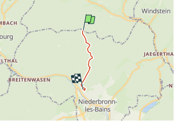
9.5 km | 14.4 km-effort
2h 30min
Yes
Trail On foot Niederbronn-les-Bains - Disque rouge - Photo
On foot
GUIDE+

On foot

Easy
Niederbronn-les-Bains, Grand Est, Bas-Rhin, France
5 km | 6.4 km-effort
1h 27min
No
Trail On foot Philippsbourg - Yellow X - Photo
On foot
GUIDE+

On foot

Easy
Philippsbourg, Grand Est, Moselle, France
7.5 km | 11 km-effort
2h 29min
No
Trail On foot Philippsbourg - Red dot - Photo
On foot
GUIDE+

On foot

Easy
Philippsbourg, Grand Est, Moselle, France
6 km | 9.3 km-effort
2h 7min
No
Trail On foot Philippsbourg - Red triangle - Photo
On foot
GUIDE+

On foot

Easy
Philippsbourg, Grand Est, Moselle, France
5.1 km | 7.3 km-effort
1h 39min
No
Trail On foot Philippsbourg - Goldenberg trail - Photo
On foot
GUIDE+

On foot

Easy
Philippsbourg, Grand Est, Moselle, France
5.3 km | 7.1 km-effort
1h 36min
No
Trail On foot Philippsbourg - Yellow cross - Photo
On foot
GUIDE+

On foot

Easy
Philippsbourg, Grand Est, Moselle, France
12.6 km | 19.4 km-effort
4h 24min
No
Trail On foot Philippsbourg - Blue dot - Photo
On foot
GUIDE+

On foot

Easy
Philippsbourg, Grand Est, Moselle, France
6.6 km | 8.3 km-effort
1h 53min
No
Trail On foot Niederbronn-les-Bains - Green triangle - Photo
On foot
GUIDE+

On foot

Difficult
Niederbronn-les-Bains, Grand Est, Bas-Rhin, France
21 km | 32 km-effort
7h 20min
No


Close
My subscriptions