Trail On foot Niederbronn-les-Bains - Déviation RECTANGLE ROUGE / GR53 / Triangle rouge par anneau bleu puis croix bleue du 8/09 au 31/12/2023 - Photo

Déviation RECTANGLE ROUGE / GR53 / Triangle rouge par anneau bleu puis croix bleue du 8/09 au 31/12/2023

© OpenStreetMap contributors
Length
Length
7.8 km
Max alt
Max alt
524 m
Uphill gradient
Uphill gradient
335 m
Km-Effort
Km-Effort  
12.2 km
Min alt
Min alt
203 m
Downhill gradient
Downhill gradient
342 m
Boucle
Boucle
Yes
Creation date :
2023-09-04 14:49:50.379
Updated on :
2023-09-04 14:54:41.086

(0 Reviews)

On foot
On foot
2h46
Difficulty : Easy

Scan this QR Code to open this trail in the SityTrail application

FREE GPS app for hiking

Logo SityTrail SityTrail

IGN / Geographical institutes

Download SityTrail from the App Store Download SityTrail from Google Play

Logo SityTrail SityTrail World

The world is yours!

Download SityTrail from the App Store Download SityTrail from Google Play Download SityTrail on Huawei AppGallery

About

Trail On foot of 7.8 km to be discovered at Grand Est, Bas-Rhin, Niederbronn-les-Bains. This trail is proposed by Dominique Baudelocque .

Description

Travaux rond point Celtic // D1062 - Niederbronn
4.87 km = déviation
Direct source Lichteneck par Rectangle Rouge / G53 = 2.877 = impasse en bas au niveau usine Celtic
Soit 2 km de plus
Attention conditions hivernale = glissant sur le 1er tiers de la croix bleue entre col de la Liese et Acacias (Niederbronn)

Elevation profile

Positioning

Country:
France
Region :
Grand Est
Department/Province :
Bas-Rhin
Municipality :
Niederbronn-les-Bains
Location:
Unknown
Start:(UTM)
398724 ; 5425790 (32U) N.

Trails nearby

Trail Walking Oberbronn - En forêt de Niederbronn de Oberbronn au château de Wasenbourg - Photo
Walking
tracegps

Walking

Medium
(1)
Oberbronn, Grand Est, Bas-Rhin, France
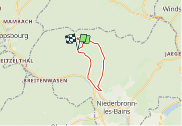
9.5 km | 14.4 km-effort
2h 30min
Yes
Trail On foot Niederbronn-les-Bains - Disque rouge - Photo
On foot
GUIDE+

On foot

Easy
Niederbronn-les-Bains, Grand Est, Bas-Rhin, France
5 km | 6.4 km-effort
1h 27min
No
Trail On foot Philippsbourg - Yellow X - Photo
On foot
GUIDE+

On foot

Easy
Philippsbourg, Grand Est, Moselle, France
7.5 km | 11 km-effort
2h 29min
No
Trail On foot Philippsbourg - Red dot - Photo
On foot
GUIDE+

On foot

Easy
Philippsbourg, Grand Est, Moselle, France
6 km | 9.3 km-effort
2h 7min
No
Trail On foot Philippsbourg - Red triangle - Photo
On foot
GUIDE+

On foot

Easy
Philippsbourg, Grand Est, Moselle, France
5.1 km | 7.3 km-effort
1h 39min
No
Trail On foot Philippsbourg - Goldenberg trail - Photo
On foot
GUIDE+

On foot

Easy
Philippsbourg, Grand Est, Moselle, France
5.3 km | 7.1 km-effort
1h 36min
No
Trail On foot Philippsbourg - Yellow cross - Photo
On foot
GUIDE+

On foot

Easy
Philippsbourg, Grand Est, Moselle, France
12.6 km | 19.4 km-effort
4h 24min
No
Trail On foot Philippsbourg - Yellow triangle - Photo
On foot
GUIDE+

On foot

Easy
Philippsbourg, Grand Est, Moselle, France
11.8 km | 15.5 km-effort
3h 30min
No
Trail On foot Baerenthal - Yellow-white-yellow rectangle - Photo
On foot
GUIDE+

On foot

Easy
Baerenthal, Grand Est, Moselle, France
3.7 km | 4.5 km-effort
1h 0min
No


Close
My subscriptions