Trail Walking Le Vivier - Le Vivier, Fajas d'en Baillette - reconnaissance  - Photo

Le Vivier, Fajas d'en Baillette - reconnaissance

© OpenStreetMap contributors
Length
Length
11.8 km
Max alt
Max alt
979 m
Uphill gradient
Uphill gradient
578 m
Km-Effort
Km-Effort  
19.6 km
Min alt
Min alt
429 m
Downhill gradient
Downhill gradient
583 m
Boucle
Boucle
Yes
Creation date :
2023-09-03 07:00:38.601
Updated on :
2023-09-03 14:40:05.291

(0 Reviews)

Walking
Walking
4h00
Difficulty : Medium

Scan this QR Code to open this trail in the SityTrail application

FREE GPS app for hiking

Logo SityTrail SityTrail

IGN / Geographical institutes

Download SityTrail from the App Store Download SityTrail from Google Play

Logo SityTrail SityTrail World

The world is yours!

Download SityTrail from the App Store Download SityTrail from Google Play Download SityTrail on Huawei AppGallery

About

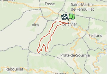
Trail Walking of 11.8 km to be discovered at Occitania, Pyrénées-Orientales, Le Vivier. This trail is proposed by Santblasi.

Description

parking église, piste DFCI 48 à droite, puis soit suivre à gauche tracé jaune ou à droite le GR 36.
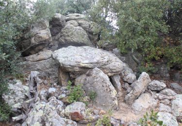
Le Fajas est abîmé.

Elevation profile

Positioning

Country:
France
Region :
Occitania
Department/Province :
Pyrénées-Orientales
Municipality :
Le Vivier
Location:
Unknown
Start:(UTM)
455170 ; 4735574 (31T) N.

Trails nearby

Trail Walking Sournia - sournia st michel - Photo
Walking
becken

Walking

Easy
(1)
Sournia, Occitania, Pyrénées-Orientales, France
7 km | 9.3 km-effort
2h 15min
Yes
Trail Walking Vira - Vira forêt de Boucherville - Photo
Walking
ombrabella

Walking

Very easy
Vira, Occitania, Pyrénées-Orientales, France
13.1 km | 18.1 km-effort
3h 22min
Yes
Trail Walking Feilluns - track - Photo
Walking
suresnois

Walking

Very difficult
Feilluns, Occitania, Pyrénées-Orientales, France
17.3 km | 24 km-effort
5h 28min
Yes
Trail Walking Le Vivier - Le Vivier. Hêtre remarquable de 500 ans - Photo
Walking
robertperello

Walking

Medium
Le Vivier, Occitania, Pyrénées-Orientales, France
13.1 km | 21 km-effort
3h 41min
Yes
Trail Walking Le Vivier - LEVIVIER - Photo
Walking
FAUCET

Walking

Very difficult
Le Vivier, Occitania, Pyrénées-Orientales, France
14.1 km | 23 km-effort
4h 16min
Yes
Trail Walking Prats-de-Sournia - prats de sournia hetre remarq.419 m 12km  - Photo
Walking
Erius

Walking

Medium
Prats-de-Sournia, Occitania, Pyrénées-Orientales, France
12.6 km | 18.2 km-effort
3h 27min
Yes
Trail Walking Sournia - Sournia - Photo
Walking
Jacpro

Walking

Difficult
Sournia, Occitania, Pyrénées-Orientales, France
11.3 km | 17.2 km-effort
4h 54min
Yes
Trail Mountain bike Caudiès-de-Fenouillèdes - Caudies de Fenouillédes-Col Saint Louis-Malabrac-Chemin du Facteur-Caudies - Photo
Mountain bike
fantomasdu94

Mountain bike

Very difficult
Caudiès-de-Fenouillèdes, Occitania, Pyrénées-Orientales, France
23 km | 33 km-effort
3h 11min
No
Trail Mountain bike Caudiès-de-Fenouillèdes - Tour des châteaux du Pays Cathare - Caudiès - Belcaire - Photo
Mountain bike
tracegps

Mountain bike

Very difficult
Caudiès-de-Fenouillèdes, Occitania, Pyrénées-Orientales, France
59 km | 88 km-effort
4h 30min
No


Close
My subscriptions