![](/images/other/stat-length.png)
![Trail Walking Belforêt-en-Perche - [Itinéraire] La fontaine de Montperthuis - Photo](https://media.geolcdn.com/t/1900/400/ext.pjpeg?maxdim=2&url=https%3A%2F%2Fstatic1.geolcdn.com%2Fsiteimages%2Fupload%2Ffiles%2F1553511878bg_sport_marche.png)
[Itinéraire] La fontaine de Montperthuis
ODDAD78
User
![Length](/images/other/stat-length.png)
![Max alt](https://static1.geolcdn.com/siteimages/upload/files/1508320355ic_sort_altitude_max_24dp.png)
![Uphill gradient](https://static1.geolcdn.com/siteimages/upload/files/1508320355ic_sort_den_pos_24dp.png)
![Km-Effort](/images/other/stat-length.png)
![Min alt](https://static1.geolcdn.com/siteimages/upload/files/1508320355ic_sort_altitude_min_24dp.png)
![Downhill gradient](https://static1.geolcdn.com/siteimages/upload/files/1508320355ic_sort_den_neg_24dp.png)
![Boucle](https://static1.geolcdn.com/siteimages/upload/files/16400158638029165_repeat_loop_refresh_sync_direction_icon.png)
![Walking](https://static1.geolcdn.com/sitytour/trail-icons/101.png)
1h29
Difficulty : Medium
![Scan this QR Code to open this trail in the SityTrail application](https://capi.geolives.com/qq0zvz2zws4bq2lad0pu/sitytour/trails/3788358/qr.png?size=200)
FREE GPS app for hiking
About
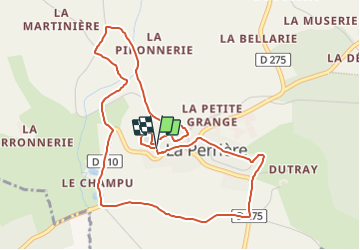
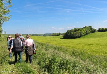
Trail Walking of 5.1 km to be discovered at Normandy, Orne, Belforêt-en-Perche. This trail is proposed by ODDAD78.
Description
Départ : La Perrière Arrivée : La Perrière Balisage : PR Communes : 1. La Perrière
Au départ de l'église Notre-Dame du Rosaire
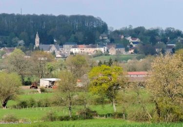
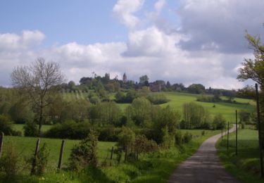
1. Longer le muret du cimetière. Faire le tour de l’Eperon tout en profitant des points de vue. Passer entre le presbytère et le clocher de l’église. Emprunter la rue Notre-Dame sur gauche, puis descendre la rue Huilerie. Prendre ensuite la première ruelle à gauche, puis à nouveau à gauche pour sortir du village.
2. À l’amorce d’une courbe, descendre à droite par un chemin creux. Franchir le ruisseau du Montperthuis sur une passerelle ; tourner à droite et, 50 m plus loin, monter à gauche. Au pied du talus, fontaine dite de Saint-Julien. Après le calvaire, bifurquer à gauche pour rejoindre le chemin empierré de la Petite Suardière. Prendre de nouveau à gauche.
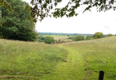
3. Arrivé sur la route de Montgaudry, descendre à gauche le GR 22 jusqu’au ruisseau. Franchir ce dernier. Prendre à droite le chemin de la Piponnerie. Traverser la route et monter en face pour gagner la D 210. Abandonner le GR 22 pour descendre la côte du Champu.
4. À l’entrée du chemin du Perruchet, suivre à gauche un petit sentier.
5. À la rencontre d’un chemin remontant au bourg, continuer tout droit. Traverser un fossé sur une
passerelle et gagner la D 275.
6. Suivre la départementale à gauche sur 250 m. Peu après l’entrée du chemin du Petit Dutray, monter
un chemin de terre débouchant, après un coude, au lotissement du Colombier. Tourner à droite et emprunter le chemin empierré du Jeu de Boules. Retour par la rue de la Juiverie, à gauche.
(Pas à pas : Rando-Perche)
Positioning
Comments
Trails nearby
![Trail Walking Belforêt-en-Perche - La Perrière, forêt et village - Photo](https://media.geolcdn.com/t/375/260/577dee63-88bb-4820-9f32-19708dbf9028.jpg&format=jpg&maxdim=2)
![Walking Walking](https://static1.geolcdn.com/sitytour/trail-icons/101.png)
Walking
![](/images/other/stat-length.png)
![](https://static1.geolcdn.com/siteimages/upload/files/16400158638029165_repeat_loop_refresh_sync_direction_icon.png)
![Trail Walking Belforêt-en-Perche - le chêne de l'école - Photo](https://media.geolcdn.com/t/375/260/ff98d102-5639-4196-8c72-5f92c76ce997.jpg&format=jpg&maxdim=2)
![Walking Walking](https://static1.geolcdn.com/sitytour/trail-icons/101.png)
Walking
![](/images/other/stat-length.png)
![](https://static1.geolcdn.com/siteimages/upload/files/16400158638029165_repeat_loop_refresh_sync_direction_icon.png)
![Trail Walking Belforêt-en-Perche - La Perrière - Saint-Germain-de-la-Coudre via Bellême (TCP) 28 km - Photo](https://media.geolcdn.com/t/375/260/f8f9cc81-98b3-4885-ae43-f599f03cc6ff.jpg&format=jpg&maxdim=2)
![Walking Walking](https://static1.geolcdn.com/sitytour/trail-icons/101.png)
Walking
![](/images/other/stat-length.png)
![](https://static1.geolcdn.com/siteimages/upload/files/16400158638029165_repeat_loop_refresh_sync_direction_icon.png)
![Trail Walking Belforêt-en-Perche - La Perrière - Saint-Germain-de-la-Coudre via Igé (TCP) 27 km - Photo](https://media.geolcdn.com/t/375/260/e70793eb-3e3a-4fb9-8791-69252ddd8772.jpg&format=jpg&maxdim=2)
![Walking Walking](https://static1.geolcdn.com/sitytour/trail-icons/101.png)
Walking
![](/images/other/stat-length.png)
![](https://static1.geolcdn.com/siteimages/upload/files/16400158638029165_repeat_loop_refresh_sync_direction_icon.png)
![Trail Walking Belforêt-en-Perche - La Perrière - Mortagne-au-Perche (TCP) 29 km - Photo](https://media.geolcdn.com/t/375/260/d8328879-50fd-44ca-9e33-04c0ec1d4331.jpg&format=jpg&maxdim=2)
![Walking Walking](https://static1.geolcdn.com/sitytour/trail-icons/101.png)
Walking
![](/images/other/stat-length.png)
![](https://static1.geolcdn.com/siteimages/upload/files/16400158638029165_repeat_loop_refresh_sync_direction_icon.png)
![Trail Walking Belforêt-en-Perche - La Perrière : village millénaire - Photo](https://media.geolcdn.com/t/375/260/ext.jpg?maxdim=2&url=https%3A%2F%2Fservices.sitytrail.com%2FGeolivesWS%2FDownloadMedia.ashx%3FTrailID%3D111665%26Media%3D7903_3.jpg)
![Walking Walking](https://static1.geolcdn.com/sitytour/trail-icons/101.png)
Walking
![](/images/other/stat-length.png)
![](https://static1.geolcdn.com/siteimages/upload/files/16400158638029165_repeat_loop_refresh_sync_direction_icon.png)
![Trail Walking Belforêt-en-Perche - la perrière par la forêt - Photo](https://media.geolcdn.com/t/375/260/dc5026c3-20c4-40ca-bab8-55b19f74d196.jpg&format=jpg&maxdim=2)
![Walking Walking](https://static1.geolcdn.com/sitytour/trail-icons/101.png)
Walking
![](/images/other/stat-length.png)
![](https://static1.geolcdn.com/siteimages/upload/files/16400158638029165_repeat_loop_refresh_sync_direction_icon.png)
![Trail Walking Belforêt-en-Perche - fourneaux gr jusqu'au ruisseau - Photo](https://media.geolcdn.com/t/375/260/b31f6ae7-3d4c-4741-ab3e-a7d27ca40061.jpg&format=jpg&maxdim=2)
![Walking Walking](https://static1.geolcdn.com/sitytour/trail-icons/101.png)
Walking
![](/images/other/stat-length.png)
![](https://static1.geolcdn.com/siteimages/upload/files/16400158638029165_repeat_loop_refresh_sync_direction_icon.png)
![Trail Walking Chemilli - ane - Photo](https://media.geolcdn.com/t/375/260/19e3a58d-7ee5-4672-83d0-dc8630fbd58f.jpg&format=jpg&maxdim=2)
![Walking Walking](https://static1.geolcdn.com/sitytour/trail-icons/101.png)