![](/images/other/stat-length.png)
![Trail Walking Saint-Chély-d'Aubrac - Compostelle / Chemin du Puy : de Aubrac à Bonneval - Photo](https://media.geolcdn.com/t/1900/400/dbc34bf8-a914-4f2b-98e8-658766b11ec6.jpg&format=pjpeg&maxdim=2)
Compostelle / Chemin du Puy : de Aubrac à Bonneval
webmammuth
User
![Length](/images/other/stat-length.png)
![Max alt](https://static1.geolcdn.com/siteimages/upload/files/1508320355ic_sort_altitude_max_24dp.png)
![Uphill gradient](https://static1.geolcdn.com/siteimages/upload/files/1508320355ic_sort_den_pos_24dp.png)
![Km-Effort](/images/other/stat-length.png)
![Min alt](https://static1.geolcdn.com/siteimages/upload/files/1508320355ic_sort_altitude_min_24dp.png)
![Downhill gradient](https://static1.geolcdn.com/siteimages/upload/files/1508320355ic_sort_den_neg_24dp.png)
![Boucle](https://static1.geolcdn.com/siteimages/upload/files/16400158638029165_repeat_loop_refresh_sync_direction_icon.png)
![Walking](https://static1.geolcdn.com/sitytour/trail-icons/101.png)
11h00
Difficulty : Difficult
![Scan this QR Code to open this trail in the SityTrail application](https://capi.geolives.com/qq0zvz2zws4bq2lad0pu/sitytour/trails/3783637/qr.png?size=200)
FREE GPS app for hiking
About
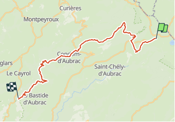
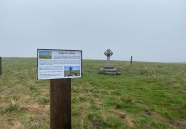
Trail Walking of 33 km to be discovered at Occitania, Aveyron, Saint-Chély-d'Aubrac. This trail is proposed by webmammuth.
Description
Attention, marche magnifique, mais difficile.
Le gps indique 33,4km en 2D, et 37km en 3D, car 2200m de dénivelé.
Les descentes sont très difficiles, et dangereuses : chaussures fermées, bien serrées, pointure et demie au dessus de votre taille.
Sac allégé si possible (portage à prévoir sur cette rando). D'autant plus qu'un minimum de 2 litres d'eau sera nécessaire à partir de Condom.
Positioning
Comments
Trails nearby
![Trail Walking Saint-Chély-d'Aubrac - Aubrac - St Côme d'Olt - Chemin de St-Jacques de Compostelle - Photo](https://media.geolcdn.com/t/375/260/ext.jpg?maxdim=2&url=https%3A%2F%2Fservices.sitytrail.com%2FGeolivesWS%2FDownloadMedia.ashx%3FTrailID%3D108743%26Media%3D1838_2.jpg)
![Walking Walking](https://static1.geolcdn.com/sitytour/trail-icons/101.png)
Walking
![](/images/other/stat-length.png)
![](https://static1.geolcdn.com/siteimages/upload/files/16400158638029165_repeat_loop_refresh_sync_direction_icon.png)
![Trail Walking Nasbinals - Nasbinals Montorzier Aubrac GR65 - Photo](https://media.geolcdn.com/t/375/260/1ac3a438-86b6-472c-99e2-7da904ac9db5.jpg&format=jpg&maxdim=2)
![Walking Walking](https://static1.geolcdn.com/sitytour/trail-icons/101.png)
Walking
![](/images/other/stat-length.png)
![](https://static1.geolcdn.com/siteimages/upload/files/16400158638029165_repeat_loop_refresh_sync_direction_icon.png)
![Trail Walking Saint-Chély-d'Aubrac - Mon chemin de St Guilhem étape 3 - Photo](https://media.geolcdn.com/t/375/260/decc6e0e-cc63-493a-98a1-a20926931e85.jpg&format=jpg&maxdim=2)
![Walking Walking](https://static1.geolcdn.com/sitytour/trail-icons/101.png)
Walking
![](/images/other/stat-length.png)
![](https://static1.geolcdn.com/siteimages/upload/files/16400158638029165_repeat_loop_refresh_sync_direction_icon.png)
![Trail Walking Curières - Le Devez cascade et forêts - Photo](https://media.geolcdn.com/t/375/260/7d8f35a5-9c7c-4d32-ad85-47f2399701b0.jpg&format=jpg&maxdim=2)
![Walking Walking](https://static1.geolcdn.com/sitytour/trail-icons/101.png)
Walking
![](/images/other/stat-length.png)
![](https://static1.geolcdn.com/siteimages/upload/files/16400158638029165_repeat_loop_refresh_sync_direction_icon.png)
![Trail On foot Nasbinals - chemin de Saint-Jacques-de-Compostelle pour randonneurs avec animaux (chien, ane, cheval) ou VTT - Photo](https://media.geolcdn.com/t/375/260/ce1c8375-c87d-45df-90e9-7235318ed55e.jpeg&format=jpg&maxdim=2)
![On foot On foot](https://static1.geolcdn.com/sitytour/trail-icons/100.png)
On foot
![](/images/other/stat-length.png)
![](https://static1.geolcdn.com/siteimages/upload/files/16400158638029165_repeat_loop_refresh_sync_direction_icon.png)
![Trail Walking Curières - Truques d’Aubrac Pas de Mathieu - Photo](https://media.geolcdn.com/t/375/260/943ba7fb-dc01-4617-b5be-555fb9d2d35b.jpg&format=jpg&maxdim=2)
![Walking Walking](https://static1.geolcdn.com/sitytour/trail-icons/101.png)
Walking
![](/images/other/stat-length.png)
![](https://static1.geolcdn.com/siteimages/upload/files/16400158638029165_repeat_loop_refresh_sync_direction_icon.png)
![Trail Walking Saint-Chély-d'Aubrac - Étape 3 Saint Gilhem - Photo](https://media.geolcdn.com/t/375/260/2821279b-f5ae-4989-8e19-441e200f8ae5.jpg&format=jpg&maxdim=2)
![Walking Walking](https://static1.geolcdn.com/sitytour/trail-icons/101.png)
Walking
![](/images/other/stat-length.png)
![](https://static1.geolcdn.com/siteimages/upload/files/16400158638029165_repeat_loop_refresh_sync_direction_icon.png)
![Trail sport Nasbinals - Nasbinal - Aubrac - Photo](https://media.geolcdn.com/t/375/260/ext.jpg?maxdim=2&url=https%3A%2F%2Fsecurestorage.geolives.com%2Fsitytour%2Ftrail-bg%2Fdefault.jpg)
sport
![](/images/other/stat-length.png)
![](https://static1.geolcdn.com/siteimages/upload/files/16400158638029165_repeat_loop_refresh_sync_direction_icon.png)
![Trail Walking Nasbinals - Nasbinals col d’Aubrac Montorzier - Photo](https://media.geolcdn.com/t/375/260/70da54ba-061f-4983-848e-b1aa9d3ce041.jpg&format=jpg&maxdim=2)
![Walking Walking](https://static1.geolcdn.com/sitytour/trail-icons/101.png)
Walking
![](/images/other/stat-length.png)
![](https://static1.geolcdn.com/siteimages/upload/files/16400158638029165_repeat_loop_refresh_sync_direction_icon.png)