Trail Electric bike Aime-la-Plagne - tour VAE Villette tessens Granier Montmery Aime - Photo

tour VAE Villette tessens Granier Montmery Aime

 melsacri
melsacri

User

© OpenStreetMap contributors
Length
Length
27 km
Max alt
Max alt
1336 m
Uphill gradient
Uphill gradient
984 m
Km-Effort
Km-Effort  
40 km
Min alt
Min alt
673 m
Downhill gradient
Downhill gradient
984 m
Boucle
Boucle
Yes
Creation date :
2023-08-24 21:02:58.528
Updated on :
2023-08-24 21:06:42.581

(0 Reviews)

Electric bike
Electric bike
0m
Difficulty : Medium

Scan this QR Code to open this trail in the SityTrail application

FREE GPS app for hiking

Logo SityTrail SityTrail

IGN / Geographical institutes

Download SityTrail from the App Store Download SityTrail from Google Play

Logo SityTrail SityTrail World

The world is yours!

Download SityTrail from the App Store Download SityTrail from Google Play Download SityTrail on Huawei AppGallery

About

Trail Electric bike of 27 km to be discovered at Auvergne-Rhône-Alpes, Savoy, Aime-la-Plagne. This trail is proposed by melsacri.

Description

tour mixte route chemin, carrossable et sentier

Elevation profile

Positioning

Country:
France
Region :
Auvergne-Rhône-Alpes
Department/Province :
Savoy
Municipality :
Aime-la-Plagne
Location:
Aime
Start:(UTM)
313822 ; 5046560 (32T) N.

Trails nearby

Trail On foot Aime-la-Plagne - Le Mont Jovet - Photo
On foot
PRO

On foot

Medium
Aime-la-Plagne, Auvergne-Rhône-Alpes, Savoy, France
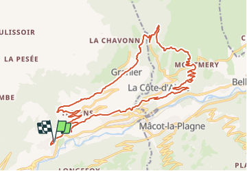
11.1 km | 21 km-effort
4h 45min
Yes
Trail On foot La Plagne-Tarentaise - Sentier Découverte Grande Rochette - Photo
On foot
PRO

On foot

Easy
La Plagne-Tarentaise, Auvergne-Rhône-Alpes, Savoy, France
9.2 km | 16.3 km-effort
3h 42min
Yes
Trail On foot Aime-la-Plagne - Route Balcon - Photo
On foot
PRO

On foot

Easy
Aime-la-Plagne, Auvergne-Rhône-Alpes, Savoy, France
7.4 km | 9.6 km-effort
2h 11min
No
Trail Walking Aime-la-Plagne - Balcons de Granier - Photo
Walking
patrando49

Walking

Easy
(2)
Aime-la-Plagne, Auvergne-Rhône-Alpes, Savoy, France
7.3 km | 12.6 km-effort
2h 48min
Yes
Trail Snowshoes Aime-la-Plagne - combe benite - Photo
Snowshoes
whisper73

Snowshoes

Difficult
(1)
Aime-la-Plagne, Auvergne-Rhône-Alpes, Savoy, France
5.3 km | 16.4 km-effort
2h 56min
No
Trail Walking Aime-la-Plagne - croix de tessins roche de janatan - Photo
Walking
Nolene

Walking

Medium
Aime-la-Plagne, Auvergne-Rhône-Alpes, Savoy, France
7.4 km | 15.2 km-effort
2h 22min
Yes
Trail Nordic walking La Plagne-Tarentaise - La Plagne 1800 Le Dou du Praz (boucle) - Photo
Nordic walking
GUIDE
lhomme.ph

Nordic walking

Easy
La Plagne-Tarentaise, Auvergne-Rhône-Alpes, Savoy, France
7.3 km | 11 km-effort
2h 8min
No
Trail Touring skiing La Plagne-Tarentaise - La Plagne 1800, Aime La Plagne, Plagne Soleil  - Photo
Touring skiing
GUIDE
lhomme.ph

Touring skiing

Medium
La Plagne-Tarentaise, Auvergne-Rhône-Alpes, Savoy, France
9.8 km | 16.5 km-effort
2h 49min
Yes
Trail Touring skiing La Plagne-Tarentaise - La Chaille. col à l'ouest du Rocher st Laurent - Photo
Touring skiing
nadd73

Touring skiing

Easy
La Plagne-Tarentaise, Auvergne-Rhône-Alpes, Savoy, France
13.9 km | 29 km-effort
6h 38min
Yes


Close
My subscriptions