![](/images/other/stat-length.png)
![Trail Walking Bessans - La Mottuaz et la Buffaz depuis Vincendières - Photo](https://media.geolcdn.com/t/1900/400/20fcd3bf-bd73-46aa-8e80-be17fc92c70e.jpg&format=pjpeg&maxdim=2)
La Mottuaz et la Buffaz depuis Vincendières
lpratz
User
![Length](/images/other/stat-length.png)
Length
11.3 km
![Max alt](https://static1.geolcdn.com/siteimages/upload/files/1508320355ic_sort_altitude_max_24dp.png)
Max alt
2504 m
![Uphill gradient](https://static1.geolcdn.com/siteimages/upload/files/1508320355ic_sort_den_pos_24dp.png)
Uphill gradient
718 m
![Km-Effort](/images/other/stat-length.png)
Km-Effort
21 km
![Min alt](https://static1.geolcdn.com/siteimages/upload/files/1508320355ic_sort_altitude_min_24dp.png)
Min alt
1805 m
![Downhill gradient](https://static1.geolcdn.com/siteimages/upload/files/1508320355ic_sort_den_neg_24dp.png)
Downhill gradient
726 m
![Boucle](https://static1.geolcdn.com/siteimages/upload/files/16400158638029165_repeat_loop_refresh_sync_direction_icon.png)
Boucle
Yes
Creation date :
2023-08-15 07:20:28.898
Updated on :
2023-08-20 22:47:46.577
![Walking](https://static1.geolcdn.com/sitytour/trail-icons/101.png)
5h48
Difficulty : Difficult
![Scan this QR Code to open this trail in the SityTrail application](https://capi.geolives.com/qq0zvz2zws4bq2lad0pu/sitytour/trails/3775923/qr.png?size=200)
FREE GPS app for hiking
About
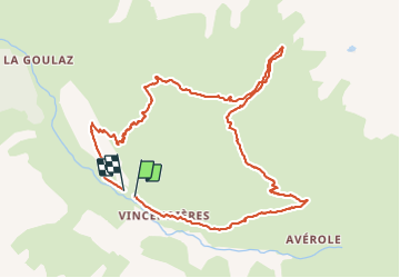
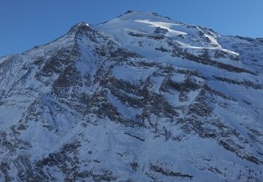
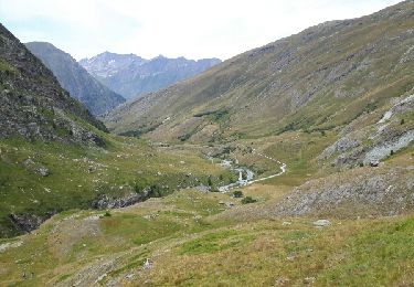
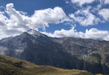
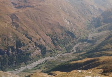
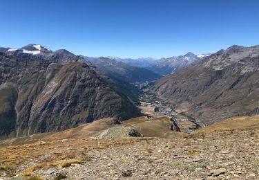
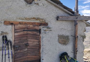
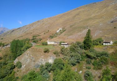
Trail Walking of 11.3 km to be discovered at Auvergne-Rhône-Alpes, Savoy, Bessans. This trail is proposed by lpratz.
Description
Une randonnée sans réelle difficulté, quelques passages hors sentier. Prévoir un déjeuner au pied de la cascade au point culminant. Dépaysement garanti !
Positioning
Country:
France
Region :
Auvergne-Rhône-Alpes
Department/Province :
Savoy
Municipality :
Bessans
Location:
Unknown
Start:(Dec)
Start:(UTM)
346118 ; 5019087 (32T) N.
Comments
Trails nearby
![Trail Touring skiing Bessans - Ouille Allegra - Photo](https://media.geolcdn.com/t/375/260/9b5085c5-d222-4758-bb24-52aa6805627c.jpg&format=jpg&maxdim=2)
![Touring skiing Touring skiing](https://static1.geolcdn.com/sitytour/trail-icons/503.png)
Ouille Allegra
Touring skiing
Medium
Bessans,
Auvergne-Rhône-Alpes,
Savoy,
France
![](/images/other/stat-length.png)
15.6 km | 34 km-effort
4h 43min
![](https://static1.geolcdn.com/siteimages/upload/files/16400158638029165_repeat_loop_refresh_sync_direction_icon.png)
Yes
![Trail Walking Bessans - refuge d'Averole - Photo](https://media.geolcdn.com/t/375/260/ext.jpg?maxdim=2&url=https%3A%2F%2Fservices.sitytrail.com%2FGeolivesWS%2FDownloadMedia.ashx%3FTrailID%3D617286%26Media%3Dfix__20160819132126.jpg)
![Walking Walking](https://static1.geolcdn.com/sitytour/trail-icons/101.png)
refuge d'Averole
Walking
Easy
Bessans,
Auvergne-Rhône-Alpes,
Savoy,
France
![](/images/other/stat-length.png)
11.1 km | 16.7 km-effort
4h 37min
![](https://static1.geolcdn.com/siteimages/upload/files/16400158638029165_repeat_loop_refresh_sync_direction_icon.png)
Yes
![Trail Walking Bessans - Glacier du grand fond à Bessans - Photo](https://media.geolcdn.com/t/375/260/61f5a8e8-d661-4c78-8114-74bcc9d0d732.jpg&format=jpg&maxdim=2)
![Walking Walking](https://static1.geolcdn.com/sitytour/trail-icons/101.png)
Glacier du grand fond à Bessans
Walking
Difficult
Bessans,
Auvergne-Rhône-Alpes,
Savoy,
France
![](/images/other/stat-length.png)
15.8 km | 34 km-effort
8h 22min
![](https://static1.geolcdn.com/siteimages/upload/files/16400158638029165_repeat_loop_refresh_sync_direction_icon.png)
No
![Trail Walking Bessans - la chapelle de tierce - Photo](https://media.geolcdn.com/t/375/260/198d2c98-080a-46a4-bb50-3b24f6158577.jpg&format=jpg&maxdim=2)
![Walking Walking](https://static1.geolcdn.com/sitytour/trail-icons/101.png)
la chapelle de tierce
Walking
Difficult
Bessans,
Auvergne-Rhône-Alpes,
Savoy,
France
![](/images/other/stat-length.png)
14.5 km | 32 km-effort
6h 19min
![](https://static1.geolcdn.com/siteimages/upload/files/16400158638029165_repeat_loop_refresh_sync_direction_icon.png)
Yes
![Trail Walking Bessans - Parking à côté de Vincendières - Ouille d'Allegra BESSAN - Photo](https://media.geolcdn.com/t/375/260/eca17c70-22c9-4bd4-954d-dbe983db8fc1.jpg&format=jpg&maxdim=2)
![Walking Walking](https://static1.geolcdn.com/sitytour/trail-icons/101.png)
Parking à côté de Vincendières - Ouille d'Allegra BESSAN
Walking
Difficult
Bessans,
Auvergne-Rhône-Alpes,
Savoy,
France
![](/images/other/stat-length.png)
12.6 km | 30 km-effort
7h 20min
![](https://static1.geolcdn.com/siteimages/upload/files/16400158638029165_repeat_loop_refresh_sync_direction_icon.png)
Yes
![Trail Walking Bessans - chapelle de tierce - Photo](https://media.geolcdn.com/t/375/260/a7930c12-dd5d-4c05-b286-cc502cf51c39.jpg&format=jpg&maxdim=2)
![Walking Walking](https://static1.geolcdn.com/sitytour/trail-icons/101.png)
chapelle de tierce
Walking
Difficult
Bessans,
Auvergne-Rhône-Alpes,
Savoy,
France
![](/images/other/stat-length.png)
13.8 km | 31 km-effort
5h 30min
![](https://static1.geolcdn.com/siteimages/upload/files/16400158638029165_repeat_loop_refresh_sync_direction_icon.png)
Yes
![Trail Snowshoes Bessans - Bessans - refuge de l Averole - Photo](https://media.geolcdn.com/t/375/260/57e25f48-0822-41db-b346-2cc23896b003.jpg&format=jpg&maxdim=2)
![Snowshoes Snowshoes](https://static1.geolcdn.com/sitytour/trail-icons/504.png)
Bessans - refuge de l Averole
Snowshoes
Difficult
Bessans,
Auvergne-Rhône-Alpes,
Savoy,
France
![](/images/other/stat-length.png)
17.8 km | 25 km-effort
5h 39min
![](https://static1.geolcdn.com/siteimages/upload/files/16400158638029165_repeat_loop_refresh_sync_direction_icon.png)
Yes
![Trail On foot Bessans - Circuit du Gypaète - Photo](https://media.geolcdn.com/t/375/260/35516eac-6b39-431a-84d8-a68319860bc8.jpg&format=jpg&maxdim=2)
![On foot On foot](https://static1.geolcdn.com/sitytour/trail-icons/100.png)
Circuit du Gypaète
On foot
Medium
Bessans,
Auvergne-Rhône-Alpes,
Savoy,
France
![](/images/other/stat-length.png)
8.3 km | 10.5 km-effort
Unknown
![](https://static1.geolcdn.com/siteimages/upload/files/16400158638029165_repeat_loop_refresh_sync_direction_icon.png)
Yes
![Trail Walking Bessans - refuge de l'avérole - Photo](https://media.geolcdn.com/t/375/260/c1e02381-b2c0-4f29-93e3-908061cf8835.jpg&format=jpg&maxdim=2)
![Walking Walking](https://static1.geolcdn.com/sitytour/trail-icons/101.png)
refuge de l'avérole
Walking
Very easy
Bessans,
Auvergne-Rhône-Alpes,
Savoy,
France
![](/images/other/stat-length.png)
11.1 km | 16.5 km-effort
4h 27min
![](https://static1.geolcdn.com/siteimages/upload/files/16400158638029165_repeat_loop_refresh_sync_direction_icon.png)
Yes