![](/images/other/stat-length.png)
![Trail Walking Nideggen - De Nideggen à Heimbach - Photo](https://media.geolcdn.com/t/1900/400/ext.pjpeg?maxdim=2&url=https%3A%2F%2Fstatic1.geolcdn.com%2Fsiteimages%2Fupload%2Ffiles%2F1553511878bg_sport_marche.png)
De Nideggen à Heimbach
© OpenStreetMap contributors
![Walking](https://static1.geolcdn.com/sitytour/trail-icons/101.png)
Walking
4h20
Difficulty : Very difficult
![Length](/images/other/stat-length.png)
Length
13.8 km
![Max alt](https://static1.geolcdn.com/siteimages/upload/files/1508320355ic_sort_altitude_max_24dp.png)
Max alt
392 m
![Uphill gradient](https://static1.geolcdn.com/siteimages/upload/files/1508320355ic_sort_den_pos_24dp.png)
Uphill gradient
407 m
![Km-Effort](/images/other/stat-length.png)
Km-Effort
19.1 km
![Min alt](https://static1.geolcdn.com/siteimages/upload/files/1508320355ic_sort_altitude_min_24dp.png)
Min alt
176 m
![Downhill gradient](https://static1.geolcdn.com/siteimages/upload/files/1508320355ic_sort_den_neg_24dp.png)
Downhill gradient
381 m
![Boucle](https://static1.geolcdn.com/siteimages/upload/files/16400158638029165_repeat_loop_refresh_sync_direction_icon.png)
Boucle
No
Creation date :
2023-08-17 16:36:53.819
Updated on :
2023-08-17 16:39:36.029
![Walking](https://static1.geolcdn.com/sitytour/trail-icons/101.png)
4h20
Difficulty : Very difficult
![Scan this QR Code to open this trail in the SityTrail application](https://capi.geolives.com/qq0zvz2zws4bq2lad0pu/sitytour/trails/3775499/qr.png?size=200)
FREE GPS app for hiking
About
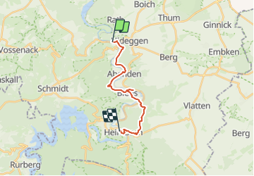
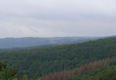
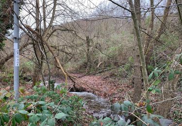
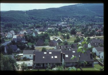
Trail Walking of 13.8 km to be discovered at North Rhine-Westphalia, Kreis Düren, Nideggen. This trail is proposed by danyhermans1607@gmail.com .
Description
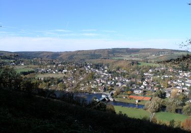
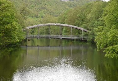
Balade au départ de Nideggen ayant laissé les voitures à Heimbach et y ayant pris le train.
Possibilité de retourner en train à Blens pour ne faire que 7.3km
Positioning
Country:
Germany
Region :
North Rhine-Westphalia
Department/Province :
Kreis Düren
Municipality :
Nideggen
Location:
Unknown
Start:(Dec)
Start:(UTM)
321006 ; 5618427 (32U) N.
Comments
Trails nearby
![Trail On foot Hürtgenwald - An der Gieschhardt - Photo](https://media.geolcdn.com/t/375/260/db32e5f9-63c8-4790-8701-1de9e82b7122.jpeg&format=jpg&maxdim=2)
![On foot On foot](https://static1.geolcdn.com/sitytour/trail-icons/100.png)
An der Gieschhardt
On foot
Easy
Hürtgenwald,
North Rhine-Westphalia,
Kreis Düren,
Germany
![](/images/other/stat-length.png)
4.4 km | 5.3 km-effort
1h 12min
![](https://static1.geolcdn.com/siteimages/upload/files/16400158638029165_repeat_loop_refresh_sync_direction_icon.png)
No
![Trail On foot Vettweiß - großer Heideweg - Photo](https://media.geolcdn.com/t/375/260/74de7dee-bba1-467c-b3f2-878909729c61.jpeg&format=jpg&maxdim=2)
![On foot On foot](https://static1.geolcdn.com/sitytour/trail-icons/100.png)
großer Heideweg
On foot
Easy
Vettweiß,
North Rhine-Westphalia,
Kreis Düren,
Germany
![](/images/other/stat-length.png)
9.3 km | 10.3 km-effort
2h 20min
![](https://static1.geolcdn.com/siteimages/upload/files/16400158638029165_repeat_loop_refresh_sync_direction_icon.png)
Yes
![Trail On foot Kreuzau - Drover-Berg-Tunnelweg - Photo](https://media.geolcdn.com/t/375/260/10cb3ec2-ead2-4e5b-a04c-a9998ff9680a.jpeg&format=jpg&maxdim=2)
![On foot On foot](https://static1.geolcdn.com/sitytour/trail-icons/100.png)
Drover-Berg-Tunnelweg
On foot
Easy
Kreuzau,
North Rhine-Westphalia,
Kreis Düren,
Germany
![](/images/other/stat-length.png)
8 km | 8.8 km-effort
2h 0min
![](https://static1.geolcdn.com/siteimages/upload/files/16400158638029165_repeat_loop_refresh_sync_direction_icon.png)
No
![Trail On foot Hürtgenwald - Panoramaweg Bergstein - Photo](https://media.geolcdn.com/t/375/260/4a013b56-75ae-4063-b45e-5ac827035946.jpeg&format=jpg&maxdim=2)
![On foot On foot](https://static1.geolcdn.com/sitytour/trail-icons/100.png)
Panoramaweg Bergstein
On foot
Easy
Hürtgenwald,
North Rhine-Westphalia,
Kreis Düren,
Germany
![](/images/other/stat-length.png)
9.4 km | 11.6 km-effort
2h 37min
![](https://static1.geolcdn.com/siteimages/upload/files/16400158638029165_repeat_loop_refresh_sync_direction_icon.png)
Yes
![Trail On foot Nideggen - Schmidter Runde - Photo](https://media.geolcdn.com/t/375/260/68d8615b-3db1-4004-9cff-4afadf42000f.jpeg&format=jpg&maxdim=2)
![On foot On foot](https://static1.geolcdn.com/sitytour/trail-icons/100.png)
Schmidter Runde
On foot
Easy
Nideggen,
North Rhine-Westphalia,
Kreis Düren,
Germany
![](/images/other/stat-length.png)
3.1 km | 3.7 km-effort
49min
![](https://static1.geolcdn.com/siteimages/upload/files/16400158638029165_repeat_loop_refresh_sync_direction_icon.png)
No
![Trail On foot Nideggen - Heinrich-Böll-Weg - Photo](https://media.geolcdn.com/t/375/260/93774cb9-256a-49ef-9a96-1bf88cdec2bd.jpeg&format=jpg&maxdim=2)
![On foot On foot](https://static1.geolcdn.com/sitytour/trail-icons/100.png)
Heinrich-Böll-Weg
On foot
Easy
Nideggen,
North Rhine-Westphalia,
Kreis Düren,
Germany
![](/images/other/stat-length.png)
6.2 km | 9.4 km-effort
2h 8min
![](https://static1.geolcdn.com/siteimages/upload/files/16400158638029165_repeat_loop_refresh_sync_direction_icon.png)
Yes
![Trail On foot Nideggen - Stauseerundweg Obermaubach - Photo](https://media.geolcdn.com/t/375/260/a4eb8832-4d42-4939-9116-6aba00f4ee97.jpeg&format=jpg&maxdim=2)
![On foot On foot](https://static1.geolcdn.com/sitytour/trail-icons/100.png)
Stauseerundweg Obermaubach
On foot
Easy
Nideggen,
North Rhine-Westphalia,
Kreis Düren,
Germany
![](/images/other/stat-length.png)
5.9 km | 8.1 km-effort
1h 50min
![](https://static1.geolcdn.com/siteimages/upload/files/16400158638029165_repeat_loop_refresh_sync_direction_icon.png)
Yes
![Trail On foot Kreuzau - Wassererlebnispfad Kreuzau - Photo](https://media.geolcdn.com/t/375/260/9bf1ce93-842d-4e9f-9703-efef2e7639e3.jpeg&format=jpg&maxdim=2)
![On foot On foot](https://static1.geolcdn.com/sitytour/trail-icons/100.png)
Wassererlebnispfad Kreuzau
On foot
Medium
Kreuzau,
North Rhine-Westphalia,
Kreis Düren,
Germany
![](/images/other/stat-length.png)
17.5 km | 21 km-effort
4h 45min
![](https://static1.geolcdn.com/siteimages/upload/files/16400158638029165_repeat_loop_refresh_sync_direction_icon.png)
No
![Trail On foot Nideggen - Um den Wildpark Schmidt - Photo](https://media.geolcdn.com/t/375/260/68d8615b-3db1-4004-9cff-4afadf42000f.jpeg&format=jpg&maxdim=2)
![On foot On foot](https://static1.geolcdn.com/sitytour/trail-icons/100.png)
Um den Wildpark Schmidt
On foot
Easy
Nideggen,
North Rhine-Westphalia,
Kreis Düren,
Germany
![](/images/other/stat-length.png)
3.2 km | 3.8 km-effort
51min
![](https://static1.geolcdn.com/siteimages/upload/files/16400158638029165_repeat_loop_refresh_sync_direction_icon.png)
No