![](/images/other/stat-length.png)
![Trail Walking Moigny-sur-École - Moigny-sur-École - Photo](https://media.geolcdn.com/t/1900/400/e39b79dd-0698-47d1-a993-eeec2e342c98.jpg&format=pjpeg&maxdim=2)
Moigny-sur-École
guydu41
User
![Length](/images/other/stat-length.png)
Length
9.6 km
![Max alt](https://static1.geolcdn.com/siteimages/upload/files/1508320355ic_sort_altitude_max_24dp.png)
Max alt
140 m
![Uphill gradient](https://static1.geolcdn.com/siteimages/upload/files/1508320355ic_sort_den_pos_24dp.png)
Uphill gradient
232 m
![Km-Effort](/images/other/stat-length.png)
Km-Effort
12.7 km
![Min alt](https://static1.geolcdn.com/siteimages/upload/files/1508320355ic_sort_altitude_min_24dp.png)
Min alt
68 m
![Downhill gradient](https://static1.geolcdn.com/siteimages/upload/files/1508320355ic_sort_den_neg_24dp.png)
Downhill gradient
232 m
![Boucle](https://static1.geolcdn.com/siteimages/upload/files/16400158638029165_repeat_loop_refresh_sync_direction_icon.png)
Boucle
Yes
Creation date :
2023-08-17 12:18:54.85
Updated on :
2023-08-19 12:54:49.362
![Walking](https://static1.geolcdn.com/sitytour/trail-icons/101.png)
2h53
Difficulty : Medium
![Scan this QR Code to open this trail in the SityTrail application](https://capi.geolives.com/qq0zvz2zws4bq2lad0pu/sitytour/trails/3775391/qr.png?size=200)
FREE GPS app for hiking
About
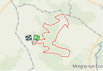
Trail Walking of 9.6 km to be discovered at Ile-de-France, Essonne, Moigny-sur-École. This trail is proposed by guydu41.
Description
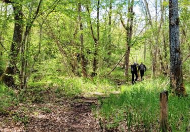
Joli petit parcours principalement sur des chemins et sentiers dans les bois.
Découverte d'un "polissoir".
Note importante : Le circuit emprunte dans le Bois de la Chapelle Sainte-Anne des passages marqués privés.
Positioning
Country:
France
Region :
Ile-de-France
Department/Province :
Essonne
Municipality :
Moigny-sur-École
Location:
Unknown
Start:(Dec)
Start:(UTM)
457309 ; 5365530 (31U) N.
Comments
Trails nearby
![Trail On foot Milly-la-Forêt - Boucle 16 km Coquibus - Platières - Photo](https://media.geolcdn.com/t/375/260/6a2a1ae6-ffd2-44a3-8670-01d58b5995c6.jpg&format=jpg&maxdim=2)
![On foot On foot](https://static1.geolcdn.com/sitytour/trail-icons/100.png)
Boucle 16 km Coquibus - Platières
On foot
Easy
Milly-la-Forêt,
Ile-de-France,
Essonne,
France
![](/images/other/stat-length.png)
16.2 km | 19.4 km-effort
4h 24min
![](https://static1.geolcdn.com/siteimages/upload/files/16400158638029165_repeat_loop_refresh_sync_direction_icon.png)
Yes
![Trail Walking Milly-la-Forêt - Boucle 29 km Milly La Forêt - Le Vaudoué - Tousson - Photo](https://media.geolcdn.com/t/375/260/3058c3db-123e-4ec5-b295-1e7b4c8ce449.jpg&format=jpg&maxdim=2)
![Walking Walking](https://static1.geolcdn.com/sitytour/trail-icons/101.png)
Boucle 29 km Milly La Forêt - Le Vaudoué - Tousson
Walking
Difficult
Milly-la-Forêt,
Ile-de-France,
Essonne,
France
![](/images/other/stat-length.png)
29 km | 33 km-effort
5h 56min
![](https://static1.geolcdn.com/siteimages/upload/files/16400158638029165_repeat_loop_refresh_sync_direction_icon.png)
Yes
![Trail Walking Milly-la-Forêt - Boucle Milly - Noisy - Le Vaudoué - Photo](https://media.geolcdn.com/t/375/260/e9bfccdb-7efb-4974-aaa0-3d18cc8b7546.jpg&format=jpg&maxdim=2)
![Walking Walking](https://static1.geolcdn.com/sitytour/trail-icons/101.png)
Boucle Milly - Noisy - Le Vaudoué
Walking
Medium
Milly-la-Forêt,
Ile-de-France,
Essonne,
France
![](/images/other/stat-length.png)
25 km | 28 km-effort
5h 28min
![](https://static1.geolcdn.com/siteimages/upload/files/16400158638029165_repeat_loop_refresh_sync_direction_icon.png)
No
![Trail Walking Boutigny-sur-Essonne - Le tour du Grand Paris via le GR1 Etape 16 Boutigny /essonne - Lardy - Photo](https://media.geolcdn.com/t/375/260/120031b3-84d9-4df8-a3d3-f842b8d2e855.jpg&format=jpg&maxdim=2)
![Walking Walking](https://static1.geolcdn.com/sitytour/trail-icons/101.png)
Le tour du Grand Paris via le GR1 Etape 16 Boutigny /essonne - Lardy
Walking
Medium
Boutigny-sur-Essonne,
Ile-de-France,
Essonne,
France
![](/images/other/stat-length.png)
26 km | 32 km-effort
5h 14min
![](https://static1.geolcdn.com/siteimages/upload/files/16400158638029165_repeat_loop_refresh_sync_direction_icon.png)
No
![Trail On foot Moigny-sur-École - Chemin des Grés et des Bruyères - Photo](https://media.geolcdn.com/t/375/260/7d52c13c-a415-4d03-a2ce-e27aab816b4f.jpeg&format=jpg&maxdim=2)
![On foot On foot](https://static1.geolcdn.com/sitytour/trail-icons/100.png)
Chemin des Grés et des Bruyères
On foot
Medium
Moigny-sur-École,
Ile-de-France,
Essonne,
France
![](/images/other/stat-length.png)
21 km | 24 km-effort
5h 23min
![](https://static1.geolcdn.com/siteimages/upload/files/16400158638029165_repeat_loop_refresh_sync_direction_icon.png)
No
![Trail Walking Milly-la-Forêt - Boucle Milly la Forêt - Vaudoué via les 3 pignons et les bords de l'école - Photo](https://media.geolcdn.com/t/375/260/b3aaafd9-8697-450d-874d-f0381566e4e6.jpg&format=jpg&maxdim=2)
![Walking Walking](https://static1.geolcdn.com/sitytour/trail-icons/101.png)
Boucle Milly la Forêt - Vaudoué via les 3 pignons et les bords de l'école
Walking
Medium
Milly-la-Forêt,
Ile-de-France,
Essonne,
France
![](/images/other/stat-length.png)
34 km | 40 km-effort
6h 54min
![](https://static1.geolcdn.com/siteimages/upload/files/16400158638029165_repeat_loop_refresh_sync_direction_icon.png)
Yes
![Trail Walking Milly-la-Forêt - 2021-02-18_18h30m33_SityTrail - 2675176 - millyx18022021 - Photo](https://media.geolcdn.com/t/375/260/38ebc48f-6666-44d8-802b-55255d54731c.jpg&format=jpg&maxdim=2)
![Walking Walking](https://static1.geolcdn.com/sitytour/trail-icons/101.png)
2021-02-18_18h30m33_SityTrail - 2675176 - millyx18022021
Walking
Very difficult
Milly-la-Forêt,
Ile-de-France,
Essonne,
France
![](/images/other/stat-length.png)
29 km | 34 km-effort
7h 39min
![](https://static1.geolcdn.com/siteimages/upload/files/16400158638029165_repeat_loop_refresh_sync_direction_icon.png)
Yes
![Trail Walking Milly-la-Forêt - Boucle autour de Milly La forêt + platières - Photo](https://media.geolcdn.com/t/375/260/2fefb966-ae2b-4b51-9f95-681a12b55af2.jpg&format=jpg&maxdim=2)
![Walking Walking](https://static1.geolcdn.com/sitytour/trail-icons/101.png)
Boucle autour de Milly La forêt + platières
Walking
Medium
Milly-la-Forêt,
Ile-de-France,
Essonne,
France
![](/images/other/stat-length.png)
25 km | 30 km-effort
7h 41min
![](https://static1.geolcdn.com/siteimages/upload/files/16400158638029165_repeat_loop_refresh_sync_direction_icon.png)
Yes
![Trail Walking Maisse - Maisse - Forêt communale de Milly-la-Forêt - Photo](https://media.geolcdn.com/t/375/260/ac13d570-05a3-405f-b57f-b7a0251ed338.jpg&format=jpg&maxdim=2)
![Walking Walking](https://static1.geolcdn.com/sitytour/trail-icons/101.png)
Maisse - Forêt communale de Milly-la-Forêt
Walking
Medium
Maisse,
Ile-de-France,
Essonne,
France
![](/images/other/stat-length.png)
8.6 km | 10.6 km-effort
2h 23min
![](https://static1.geolcdn.com/siteimages/upload/files/16400158638029165_repeat_loop_refresh_sync_direction_icon.png)
Yes