Trail Hybrid bike Coye-la-Forêt - Coye la foret Avilly Chantilly coye la foret - Photo

Coye la foret Avilly Chantilly coye la foret

© OpenStreetMap contributors
Length
Length
17.9 km
Max alt
Max alt
88 m
Uphill gradient
Uphill gradient
182 m
Km-Effort
Km-Effort  
20 km
Min alt
Min alt
36 m
Downhill gradient
Downhill gradient
183 m
Boucle
Boucle
Yes
Creation date :
2023-08-15 13:41:59.0
Updated on :
2023-08-16 06:55:37.423

(0 Reviews)

Hybrid bike
Hybrid bike
1h58
Difficulty : Easy

Scan this QR Code to open this trail in the SityTrail application

FREE GPS app for hiking

Logo SityTrail SityTrail

IGN / Geographical institutes

Download SityTrail from the App Store Download SityTrail from Google Play

Logo SityTrail SityTrail World

The world is yours!

Download SityTrail from the App Store Download SityTrail from Google Play Download SityTrail on Huawei AppGallery

About

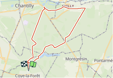
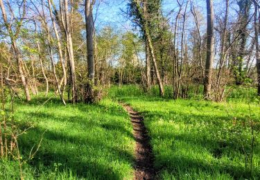
Trail Hybrid bike of 17.9 km to be discovered at Hauts-de-France, Oise, Coye-la-Forêt. This trail is proposed by KHEOPS BEN FILLY.

Description

Attention : ce parcours ne doit être fait que l après midi après 13 h car il est parallèle parfois aux pistes d entraînement des chevaux .
départ devant le château de Coye la Foret allée des Peupliers
suivre le GR après le château de la Reine Blanche
Après Avilly St Léonard rejoindre le château de Chantilly par la Sente de Sylvie
arrêt devant le château pour déguster une glace et visiter le parc - parking à vélos
retour par une piste parallèle à la piste des Lions
quelques courts passages dans le sable

Elevation profile

Positioning

Country:
France
Region :
Hauts-de-France
Department/Province :
Oise
Municipality :
Coye-la-Forêt
Location:
Unknown
Start:(UTM)
461235 ; 5443809 (31U) N.

Trails nearby

Trail Walking Orry-la-Ville - Dans la forêt des moines - Orry-la-Ville - Photo
Walking
tracegps

Walking

Medium
(2)
Orry-la-Ville, Hauts-de-France, Oise, France
9.2 km | 11.2 km-effort
2h 30min
Yes
Trail Walking Coye-la-Forêt - SM_COYE la FORET_7.9Km - Photo
Walking
GR77LP

Walking

Medium
(5)
Coye-la-Forêt, Hauts-de-France, Oise, France
7.9 km | 10 km-effort
2h 40min
Yes
Trail Walking Orry-la-Ville - SM_MONTGRESIN_EST_8.2Km - Photo
Walking
GR77LP

Walking

Medium
(5)
Orry-la-Ville, Hauts-de-France, Oise, France
8.2 km | 9.2 km-effort
1h 51min
Yes
Trail Walking Luzarches - Autour d'Orry la Ville - Photo
Walking
tracegps

Walking

Medium
(1)
Luzarches, Ile-de-France, Val-d'Oise, France
22 km | 26 km-effort
4h 25min
Yes
Trail Walking Orry-la-Ville - La forêt des étangs de Comelle - Orry la Ville - Photo
Walking
tracegps

Walking

Medium
(1)
Orry-la-Ville, Hauts-de-France, Oise, France
11.4 km | 13 km-effort
4h 0min
Yes
Trail Walking Orry-la-Ville - FORET DE COYE BOUCLE 16 KM - Photo
Walking
gemau77

Walking

Very difficult
(1)
Orry-la-Ville, Hauts-de-France, Oise, France
16.3 km | 19.4 km-effort
4h 23min
No
Trail Walking Coye-la-Forêt - Boucle autour des étangs de Commelles - Photo
Walking
GUIDE
chessyca

Walking

Very easy
Coye-la-Forêt, Hauts-de-France, Oise, France
23 km | 26 km-effort
5h 5min
Yes
Trail Walking Orry-la-Ville - Le tour du grand paris via le GR1  Etape 8 Coye - Dammartin - Photo
Walking
GUIDE
chessyca

Walking

Difficult
Orry-la-Ville, Hauts-de-France, Oise, France
38 km | 44 km-effort
8h 47min
No
Trail Walking Orry-la-Ville - SityTrail - 3204661 - gr1-orry-la-ville - Photo
Walking
GUIDE
chessyca

Walking

Difficult
Orry-la-Ville, Hauts-de-France, Oise, France
38 km | 44 km-effort
10h 5min
No


Close
My subscriptions