Trail Walking Ashford - Godmersham walk  - Photo

Godmersham walk

 fb30
fb30

User

© OpenStreetMap contributors
Length
Length
7.8 km
Max alt
Max alt
126 m
Uphill gradient
Uphill gradient
163 m
Km-Effort
Km-Effort  
10 km
Min alt
Min alt
25 m
Downhill gradient
Downhill gradient
161 m
Boucle
Boucle
Yes
Creation date :
2023-08-13 13:50:35.0
Updated on :
2023-08-13 16:06:17.962

(0 Reviews)

Walking
Walking
2h15
Difficulty : Medium

Scan this QR Code to open this trail in the SityTrail application

FREE GPS app for hiking

Logo SityTrail SityTrail

IGN / Geographical institutes

Download SityTrail from the App Store Download SityTrail from Google Play

Logo SityTrail SityTrail World

The world is yours!

Download SityTrail from the App Store Download SityTrail from Google Play Download SityTrail on Huawei AppGallery

About

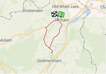
Trail Walking of 7.8 km to be discovered at England, Kent, Ashford. This trail is proposed by fb30.

Elevation profile

Positioning

Country:
United Kingdom
Region :
England
Department/Province :
Kent
Municipality :
Ashford
Location:
Unknown
Start:(UTM)
357576 ; 5678936 (31U) N.

Trails nearby

Trail Motor Folkestone and Hythe - a-engeland-wales-2005 - Photo
Motor
gpstracks

Motor

Very easy
Folkestone and Hythe, England, Kent, United Kingdom
1579 km | 2130 km-effort
Unknown
No
Trail Motor Folkestone and Hythe - a-engeland-6-daagse-small-roads-trip-zuid-engeland - Photo
Motor
gpstracks

Motor

Very easy
Folkestone and Hythe, England, Kent, United Kingdom
1190 km | 1494 km-effort
Unknown
Yes
Trail Road bike Canterbury - Gaver shampoing  - Photo
Road bike
phicel

Road bike

Canterbury, England, Kent, United Kingdom
53 km | 0 m-effort
4h 18min
No


Close
My subscriptions