![](/images/other/stat-length.png)
![Trail Walking Négrondes - Négrondes Fontaines longue 13km - Photo](https://media.geolcdn.com/t/1900/400/ext.pjpeg?maxdim=2&url=https%3A%2F%2Fstatic1.geolcdn.com%2Fsiteimages%2Fupload%2Ffiles%2F1553511878bg_sport_marche.png)
Négrondes Fontaines longue 13km
YV24
User
![Length](/images/other/stat-length.png)
Length
12.8 km
![Max alt](https://static1.geolcdn.com/siteimages/upload/files/1508320355ic_sort_altitude_max_24dp.png)
Max alt
227 m
![Uphill gradient](https://static1.geolcdn.com/siteimages/upload/files/1508320355ic_sort_den_pos_24dp.png)
Uphill gradient
187 m
![Km-Effort](/images/other/stat-length.png)
Km-Effort
15.3 km
![Min alt](https://static1.geolcdn.com/siteimages/upload/files/1508320355ic_sort_altitude_min_24dp.png)
Min alt
144 m
![Downhill gradient](https://static1.geolcdn.com/siteimages/upload/files/1508320355ic_sort_den_neg_24dp.png)
Downhill gradient
186 m
![Boucle](https://static1.geolcdn.com/siteimages/upload/files/16400158638029165_repeat_loop_refresh_sync_direction_icon.png)
Boucle
Yes
Creation date :
2015-02-23 00:00:00.0
Updated on :
2015-02-23 00:00:00.0
![Walking](https://static1.geolcdn.com/sitytour/trail-icons/101.png)
3h20
Difficulty : Easy
![Scan this QR Code to open this trail in the SityTrail application](https://capi.geolives.com/qq0zvz2zws4bq2lad0pu/sitytour/trails/377018/qr.png?size=200)
FREE GPS app for hiking
About
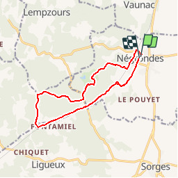
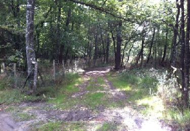
Trail Walking of 12.8 km to be discovered at New Aquitaine, Dordogne, Négrondes. This trail is proposed by YV24.
Description
Variante PDIPR Boucle des Fontaines allongée à 13 km.
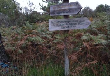
Environ 2km de route entre les Rebières et après Rochemorin. Praticable en tout temps. Pas de balisage entre les Rebières et Fontaine de la Roche.
Positioning
Country:
France
Region :
New Aquitaine
Department/Province :
Dordogne
Municipality :
Négrondes
Location:
Unknown
Start:(Dec)
Start:(UTM)
332720 ; 5023568 (31T) N.
Comments
Trails nearby
![Trail sport Sorges et Ligueux en Périgord - 2020-09-03_17h34m25_20-10-20 Ligueux - Photo](https://media.geolcdn.com/t/375/260/ext.jpg?maxdim=2&url=https%3A%2F%2Fsecurestorage.geolives.com%2Fsitytour%2Ftrail-bg%2Fdefault.jpg)
2020-09-03_17h34m25_20-10-20 Ligueux
sport
Very easy
(1)
Sorges et Ligueux en Périgord,
New Aquitaine,
Dordogne,
France
![](/images/other/stat-length.png)
10.5 km | 13.4 km-effort
Unknown
![](https://static1.geolcdn.com/siteimages/upload/files/16400158638029165_repeat_loop_refresh_sync_direction_icon.png)
Yes
![Trail Walking Sorges et Ligueux en Périgord - Sorges Causses et sous bois 10 km - Photo](https://media.geolcdn.com/t/375/260/ext.jpg?maxdim=2&url=https%3A%2F%2Fstatic1.geolcdn.com%2Fsiteimages%2Fupload%2Ffiles%2F1553511878bg_sport_marche.png)
![Walking Walking](https://static1.geolcdn.com/sitytour/trail-icons/101.png)
Sorges Causses et sous bois 10 km
Walking
Easy
(1)
Sorges et Ligueux en Périgord,
New Aquitaine,
Dordogne,
France
![](/images/other/stat-length.png)
9.9 km | 12.6 km-effort
1h 49min
![](https://static1.geolcdn.com/siteimages/upload/files/16400158638029165_repeat_loop_refresh_sync_direction_icon.png)
Yes
![Trail Walking Sorges et Ligueux en Périgord - Sorges Téléthon 2013 11km - Photo](https://media.geolcdn.com/t/375/260/ext.jpg?maxdim=2&url=https%3A%2F%2Fstatic1.geolcdn.com%2Fsiteimages%2Fupload%2Ffiles%2F1553511878bg_sport_marche.png)
![Walking Walking](https://static1.geolcdn.com/sitytour/trail-icons/101.png)
Sorges Téléthon 2013 11km
Walking
Easy
(1)
Sorges et Ligueux en Périgord,
New Aquitaine,
Dordogne,
France
![](/images/other/stat-length.png)
11 km | 13.2 km-effort
2h 57min
![](https://static1.geolcdn.com/siteimages/upload/files/16400158638029165_repeat_loop_refresh_sync_direction_icon.png)
Yes
![Trail Walking Sorges et Ligueux en Périgord - Marche du dimanche 15 janvier à Ligueux - Photo](https://media.geolcdn.com/t/375/260/ca66f548-4426-4827-980d-dc4041496b72.jpg&format=jpg&maxdim=2)
![Walking Walking](https://static1.geolcdn.com/sitytour/trail-icons/101.png)
Marche du dimanche 15 janvier à Ligueux
Walking
Easy
Sorges et Ligueux en Périgord,
New Aquitaine,
Dordogne,
France
![](/images/other/stat-length.png)
6.8 km | 8.6 km-effort
1h 39min
![](https://static1.geolcdn.com/siteimages/upload/files/16400158638029165_repeat_loop_refresh_sync_direction_icon.png)
No
![Trail Walking Sorges et Ligueux en Périgord - Boucle de l'Abbatiale - Photo](https://media.geolcdn.com/t/375/260/9612e021-d9e0-4a16-be1e-ceb9f3a734d7.jpg&format=jpg&maxdim=2)
![Walking Walking](https://static1.geolcdn.com/sitytour/trail-icons/101.png)
Boucle de l'Abbatiale
Walking
Easy
Sorges et Ligueux en Périgord,
New Aquitaine,
Dordogne,
France
![](/images/other/stat-length.png)
7.3 km | 8.9 km-effort
2h 1min
![](https://static1.geolcdn.com/siteimages/upload/files/16400158638029165_repeat_loop_refresh_sync_direction_icon.png)
Yes
![Trail Walking Sorges et Ligueux en Périgord - De Sorges à Perigueux sur la voie de Compostelle - Photo](https://media.geolcdn.com/t/375/260/4aaf4236-90c5-474d-8de9-7f6175f80c96.jpeg&format=jpg&maxdim=2)
![Walking Walking](https://static1.geolcdn.com/sitytour/trail-icons/101.png)
De Sorges à Perigueux sur la voie de Compostelle
Walking
Very difficult
Sorges et Ligueux en Périgord,
New Aquitaine,
Dordogne,
France
![](/images/other/stat-length.png)
25 km | 31 km-effort
5h 26min
![](https://static1.geolcdn.com/siteimages/upload/files/16400158638029165_repeat_loop_refresh_sync_direction_icon.png)
No
![Trail Walking Eyzerac - La Servolle 2 - Photo](https://media.geolcdn.com/t/375/260/ext.jpg?maxdim=2&url=https%3A%2F%2Fservices.sitytrail.com%2FGeolivesWS%2FDownloadMedia.ashx%3FTrailID%3D226050%26Media%3D20131008110344.jpg)
![Walking Walking](https://static1.geolcdn.com/sitytour/trail-icons/101.png)
La Servolle 2
Walking
Easy
Eyzerac,
New Aquitaine,
Dordogne,
France
![](/images/other/stat-length.png)
12.4 km | 14.9 km-effort
3h 16min
![](https://static1.geolcdn.com/siteimages/upload/files/16400158638029165_repeat_loop_refresh_sync_direction_icon.png)
Yes
![Trail Walking Sorges et Ligueux en Périgord - Boucle des châteaux - Photo](https://media.geolcdn.com/t/375/260/ba5fb264-42c9-43e2-90fa-f6bdc036a39c.jpg&format=jpg&maxdim=2)
![Walking Walking](https://static1.geolcdn.com/sitytour/trail-icons/101.png)
Boucle des châteaux
Walking
Difficult
Sorges et Ligueux en Périgord,
New Aquitaine,
Dordogne,
France
![](/images/other/stat-length.png)
14.4 km | 17.2 km-effort
3h 54min
![](https://static1.geolcdn.com/siteimages/upload/files/16400158638029165_repeat_loop_refresh_sync_direction_icon.png)
Yes
![Trail Walking Vaunac - Vaunac-St Chavit - Photo](https://media.geolcdn.com/t/375/260/ext.jpg?maxdim=2&url=https%3A%2F%2Fservices.sitytrail.com%2FGeolivesWS%2FDownloadMedia.ashx%3FTrailID%3D226520%26Media%3D20131011113305.jpg)
![Walking Walking](https://static1.geolcdn.com/sitytour/trail-icons/101.png)
Vaunac-St Chavit
Walking
Very easy
Vaunac,
New Aquitaine,
Dordogne,
France
![](/images/other/stat-length.png)
9.9 km | 12.6 km-effort
2h 39min
![](https://static1.geolcdn.com/siteimages/upload/files/16400158638029165_repeat_loop_refresh_sync_direction_icon.png)
Yes