Trail Walking Kruth - Kruth bockloch - Photo

Kruth bockloch

 philvor
philvor

User

© OpenStreetMap contributors
Length
Length
10.8 km
Max alt
Max alt
957 m
Uphill gradient
Uphill gradient
476 m
Km-Effort
Km-Effort  
17.3 km
Min alt
Min alt
523 m
Downhill gradient
Downhill gradient
511 m
Boucle
Boucle
No
Creation date :
2023-08-13 09:08:14.0
Updated on :
2023-08-13 12:52:39.892

(0 Reviews)

Walking
Walking
3h42
Difficulty : Medium

Scan this QR Code to open this trail in the SityTrail application

FREE GPS app for hiking

Logo SityTrail SityTrail

IGN / Geographical institutes

Download SityTrail from the App Store Download SityTrail from Google Play

Logo SityTrail SityTrail World

The world is yours!

Download SityTrail from the App Store Download SityTrail from Google Play Download SityTrail on Huawei AppGallery

About

Trail Walking of 10.8 km to be discovered at Grand Est, Haut-Rhin, Kruth. This trail is proposed by philvor.

Description

Kruth du camping au Hinter bockloch plus tour du lac

Elevation profile

Positioning

Country:
France
Region :
Grand Est
Department/Province :
Haut-Rhin
Municipality :
Kruth
Location:
Unknown
Start:(UTM)
346973 ; 5313095 (32T) N.

Trails nearby

Trail Walking Wildenstein - 2022-02-20 Marche Kruth Grand Ventron - Photo
Walking
GUIDE
holtzv

Walking

Very difficult
(1)
Wildenstein, Grand Est, Haut-Rhin, France
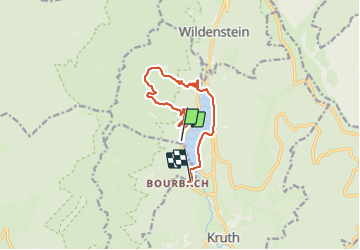
16.8 km | 27 km-effort
4h 52min
Yes
Trail Walking Wildenstein - TREK ALSACIEN (boucle de Wildenstein) - Photo
Walking
Godasses et Grosses Pattes

Walking

Difficult
(1)
Wildenstein, Grand Est, Haut-Rhin, France
15.4 km | 24 km-effort
5h 20min
Yes
Trail Walking La Bresse - Autour du Lac des Corbeaux - Photo
Walking
Alfredy

Walking

Medium
(1)
La Bresse, Grand Est, Vosges, France
3.1 km | 6 km-effort
1h 30min
Yes
Trail Walking Cornimont - Xoulces _ Grand Ventron _ Vieille Montagne - Photo
Walking
jeanclaude12

Walking

Medium
(1)
Cornimont, Grand Est, Vosges, France
15.6 km | 25 km-effort
5h 6min
No
Trail Walking La Bresse - Le Lac des Corbeaux - La Bresse - Photo
Walking
tracegps

Walking

Medium
(2)
La Bresse, Grand Est, Vosges, France
3 km | 6 km-effort
2h 0min
Yes
Trail Walking Fellering - Felsach _chapelle ST Nicolas_frenz - Photo
Walking
Le grand Claude

Walking

Difficult
(3)
Fellering, Grand Est, Haut-Rhin, France
9.6 km | 16.5 km-effort
3h 45min
Yes
Trail Walking Oderen - 6146369-Chapelle St Nicolas 2 - Photo
Walking

Walking

Medium
(1)
Oderen, Grand Est, Haut-Rhin, France
10.9 km | 17.9 km-effort
3h 41min
Yes
Trail Walking La Bresse - lac des corbeaux, le grand ventron  - Photo
Walking
grattounette

Walking

Difficult
(1)
La Bresse, Grand Est, Vosges, France
22 km | 35 km-effort
7h 39min
Yes
Trail Walking Kruth - barrage de Wildenstein et Grand Ventron - Photo
Walking
egodard

Walking

Medium
(1)
Kruth, Grand Est, Haut-Rhin, France
13.7 km | 24 km-effort
4h 40min
Yes


Close
My subscriptions